
Severe damage, power outages after possible tornado in Stevensville, Maryland
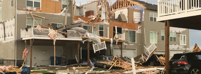
Featured image: Damage after possible tornado touches down in Stevensville, Maryland on July 24, 2017. Credit: John Gonzales (via Twitter)
The Bay City area in Stevensville, Maryland suffered significant damage after a possible tornado touched down early Monday, July 24, 2017. At least one person was injured and thousands were left without power.
A line of severe thunderstorms brought heavy rain and strong winds to central Maryland late Sunday, July 23 into July 24. Flash floods were reported in Carroll, Baltmore, and Harford counties.
Authorities said Bay City area in Stevensville suffered the most significant damage, adding that they are performing a grid search to check on residents who may be in need.
At this time, it is known that multiple homes suffered damage in Queen Anne's County area and at least 8 000 are without power as of 05:30 EDT (09:30 UTC) after the storm downed at least two power poles and numerous trees.
The Queen Anne's County Sheriff's Office said 05:45 EDT (09:45 UTC) that state and local law enforcement, fire, and emergency services are all on scene to assist those affected by the severe weather event while also surveying the amount of damage done. "Right now Rt. 8 South (Romancoke Road) is closed to local and emergency services only. If you need assistance- please reach out," the sheriff's office said.
Sheriff Hofmann added there is an emergency shelter opened at Centreville Middle School for anyone in need.
Ellendale community one of the hardest hit. Roofs and walls of homes ripped off. Other homes leveled. Cars damaged. We are LIVE on @ABC7News pic.twitter.com/Kv8nCGMFlO
— John Gonzalez (@ABC7John) July 24, 2017
WBAL quoted police saying one person was taken to a hospital in Queen Anne's County for a puncture wound with non-life-threatening injuries.
Route 8 to parts of Route 50 are without power and people living in Southern Kent Island are asked to refrain from travel so that Route 8 can be kept clear for first responders, officials said.
The National Weather Service in Mount Holly, New Jersey, says any decisions on a storm survey in the county will be made after coordination with local emergency management later this morning. The National Weather Service will determine whether a tornado touched down.
According to NWS forecast, severe thunderstorms may develop Monday afternoon and evening over portions of the Mid Atlantic and Northeast U.S.
A few of the storms could contain damaging winds, large hail, and heavy rainfall. The severe weather threat will shift to the upper Midwest and Great Lakes by Tuesday and Wednesday of this week.
I'm a dedicated researcher, journalist, and editor at The Watchers. With over 20 years of experience in the media industry, I specialize in hard science news, focusing on extreme weather, seismic and volcanic activity, space weather, and astronomy, including near-Earth objects and planetary defense strategies. You can reach me at teo /at/ watchers.news.
Commenting rules and guidelines
We value the thoughts and opinions of our readers and welcome healthy discussions on our website. In order to maintain a respectful and positive community, we ask that all commenters follow these rules.