
Mandatory evacuations ordered in parts of California
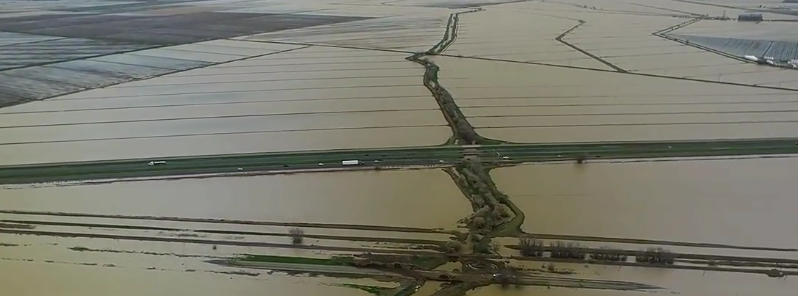
Image credit: California National Guard
Mandatory evacuations have been ordered in parts of Northern California Monday, February 20, 2017, as another heavy rainmaker slammed the region.
Many rivers in Northern California are at or above flood stage after a series of powerful storms hit the state in recent months. There are reports of flooded streets and trees and debris crashing into roadways. More than a dozen reports of flooding and debris flows have come in Monday from as far south as Monterey and as far north as Santa Rosa, according to The Weather Channel.
Two people have lost their lives Monday morning on a rural road between Oakdale and Waterford after head-on crash due to wet road, bringing the total death toll in California to 9 in just a few days.
I-80 westbound is currently closed from the Nevada state line through Donner Pass due to multiple vehicle collisions.
Weather Nation
Video courtesy Live Storms Media
On Monday night (local time), an evacuation was ordered by San Joaquin County after a report of a levee breach in a rural area southwest of Manteca. The order to evacuate roughly 500 people was ordered at 19:16 but the breach was eventually halted, the country's Office of Emergency Services reported at 20:45.
The damaged levee is on the San Joaquin River, so water is moving north and east, OES said as reported by The Sacramento Bee. The City of Ripon issued a release saying none of its residents would be affected.
For the first time since 1997, the controlled spillway gates of Don Pedro Reservoir in Tuolumne County were opened Monday afternoon. The outflows from the reservoir were between 18 000 and 22 000 cubic feet per second as of 15:00 local time Monday. The Turlock Irrigation District, providing water to much of California's Central Valley, said the spillway will be open for at least 4 days.
Don Pedro Controlled Spillway Gate has been opened. #DonPedroSpill pic.twitter.com/ejvzkmb71C
— TID (@TurlockID) February 20, 2017
Don Pedro Spillway flow over Bonds Flat Road. pic.twitter.com/m2pWTZKO8s
— Tuolumne Co. Sheriff (@TuolumneSheriff) February 21, 2017
When the releases began, the reservoir was at 251 m (825 feet) in elevation, 1.5 m (5 feet) below maximum capacity, according to the California Department of Water Resources.
After flowing from the reservoir, the water will go down the spillway, take a hard left and follow a channel that was cut out in 1997. It will then rejoin the Tuolumne River about a mile downstream, KCRA reported.
Residents living downstream of the Don Pedro Reservoir are preparing for flooding as water levels on the Tuolumne River are expected to rise. Mandatory evacuations haven’t been issued, but authorities are starting to advise some people to seek shelter and move to higher ground. The Tuolumne River is expected to peak at 19.2 m (62.9 feet) late Tuesday.
Monterey County issued mandatory evacuation orders for people near creeks and rivers. Neighborhoods in Salinas, Carmel and Royal Oak were ordered to evacuate.
Mandatory evacuation orders have also been issued for portions of Lakeport due to rising flood waters, officials said.
A pre-evacuation advisory has been issued for several roads near downtown North Fork after water discharges from Bass Lake increased and threatened to swell rivers. The sheriff's office says residents who live in the area should be ready to leave quickly if conditions worsen.
The repair of damaged spillways at the Oroville Dam continues and officials believe the reservoir will be able to withstand this current storm. Rock, aggregate, and cement slurry continue to be placed into areas affected by erosion and this work will continue 24 hours a day, the officials said.
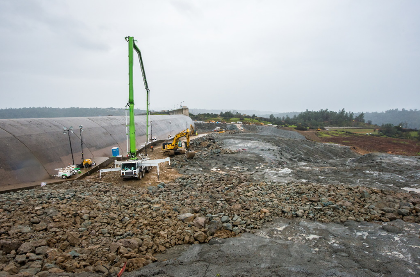
Repairs on damaged Oroville Dam spillway on February 19, 2017. Credit: CDW
As of 17:00 PST, over 35 000 PG&E customers were without power across Central and Northern California, and the number of power outages across the state was expected to rise into Tuesday, February 21.
Heavy snow falling the Sierra increased risk of avalanches, forcing the closure of US 50 between Meyers and Twin Bridges.
Video courtesy Live Storms Media
This is raw video recorded on Sunday, February 19, 2017 from a California National Guard helicopter flying over northern California rivers with officials from the Governor's Office of Emergency Services, California National Guard and others. They were surveying river conditions, levees and localized flooding impacts in a few communities reported to have flooding near Sacramento.
According to the National Weather Service, storms will continue to bring heavy rain, flooding and strong winds to California and many states across the west. Heavy rain will result in flooding for some areas, and heavy snow will be possible at high elevation locations. By mid-week, these storms may bring heavy snow to the northern Rockies and Intermountain west. Heavy rain and flooding will also impact the central Gulf Coast this week.
The Watchers team and our contributors bring the latest on extreme weather, earthquakes, volcanic eruptions, space weather, and all things science. We're all about making sense of the natural world and keeping you informed on what’s happening. Got a tip or a question? Hit us up using the form at newstips!
Commenting rules and guidelines
We value the thoughts and opinions of our readers and welcome healthy discussions on our website. In order to maintain a respectful and positive community, we ask that all commenters follow these rules.