
Model calls for excessive snowfall in south-central Italy and Sicily
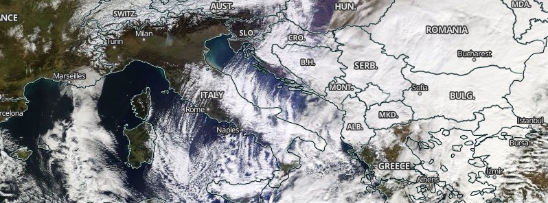
Image credit: Cloud streets producing sea-effect snowfall over the Adriatic and Tyrrhenian seas.
Latest update from the Wrfitalia Meteo model for the ongoing Adriatic/Tyrrhenian sea-effect-snowfall over south-central Italy and Sicily calls for excessive snowfall over the coming days. Meanwhile, cold arctic airmass is spreading further south across central Europe and is already far south over the Balkan peninsula and even southern France. At the same time, severe bora winds are affecting Croatian coast and Montenegro.
With an extremely cold airmass advecting over relatively warm seas, convective lines are maintaining going ashore and producing intense snowfall combined with orographic features and a so-called "stau" effect excessive snowfall, Severe Weather Europe experts explained.
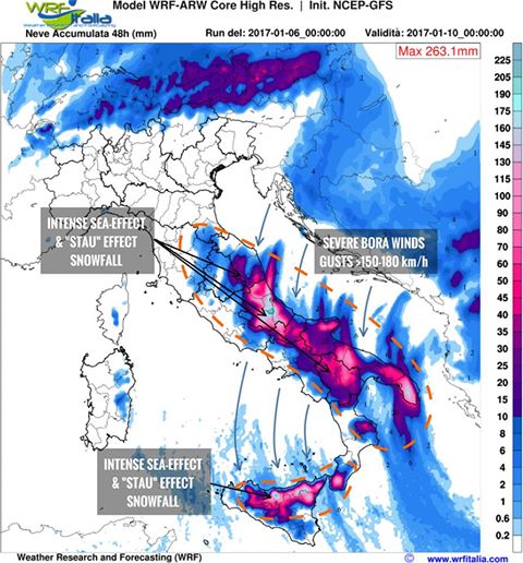
Image credit: wrfitalia.com. Annotation: Severe Weather Europe
Latest models are hinting Abruzzo as the region with the highest amounts expected.
The following images were taken today in Pescocostanzo, Abruzzo region by Alessio Costabile and Alessandra Spallarossa:
Meanwhile, cold arctic airmass is spreading further south across central Europe and is already far south over the Balkan peninsula and even southern France. At the same time, severe bora winds are hitting the eastern Adriatic.
Locally strong winds are pushing real feel below – 20 °C (-4 °F) in these areas while eastern Poland, northern Ukraine, and Belarus are experiencing -25 °C (-13 °F) to -35 °C (- 31 °F) windchills, towards -50 °C (-58 °F) in Russia.
A deep cyclone is centered over the Aegean sea, maintaining still mild temperatures over the southern Greece and Turkey – this will significantly cool through until the evening, the Severe Weather Europe said.
Meteoalarm, a network of European meteorological services, has issued a Red Alert for extremely cold temperatures for entire Italy and Montenegro, valid January 6 and 7. Red alerts for extremely cold temperatures are in effect throughout Austria and along the entire Croatian coast. Red alerts for strong winds are in effect along the Croatian coast and in Montenegro.
Meteoalarm for January 6, 2017: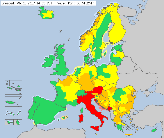
Credit: Meteoalarm
- Extreme low temperatures along the coast of Croatia; in Italy mainland, Sicily and Sardinia islands; Montenegro – Red Alert.
- Strong winds along the coast of Croatia; in southern Montenegro – Red Alert.
- Extreme low temperatures in western Croatia; central Montenegro – Orange Alert.
- Strong winds in eastern and northern Bulgaria; in central-eastern former Yugoslav Republic of Macedonia; south-western Bosnia-Herzegovina; in Hungary; western and northern Slovenia; southern Italy; southern Switzerland; north-eastern and southern Germany; south-easternRomania and in western Finland – Orange Alert.
- Snow/Ice in Greece mainland; southern Romania; northern and eastern Bulgaria; northernMontenegro; eastern Serbia; southern and eastern Republic of Moldova; northern and easternCzech Republic; northern and central Austria; central-eastern and south-eastern Italy and in southern Germany – Orange Alert.
- Thunderstorms in Greece, Aegean, Cyclades, Dodecanese and Crete islands – Orange Alert.
- Coastal events in north-eastern Spain, and Menorca and Mallorca islands – Orange Alert.
- Risk of avalanches in central and western Norway – Orange Alert.
The Watchers team and our contributors bring the latest on extreme weather, earthquakes, volcanic eruptions, space weather, and all things science. We're all about making sense of the natural world and keeping you informed on what’s happening. Got a tip or a question? Hit us up using the form at newstips!
Commenting rules and guidelines
We value the thoughts and opinions of our readers and welcome healthy discussions on our website. In order to maintain a respectful and positive community, we ask that all commenters follow these rules.