
Extremely dangerous M7.8 earthquake hit near Christchurch, New Zealand
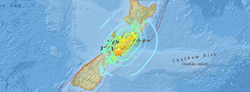
Image credit: USGS
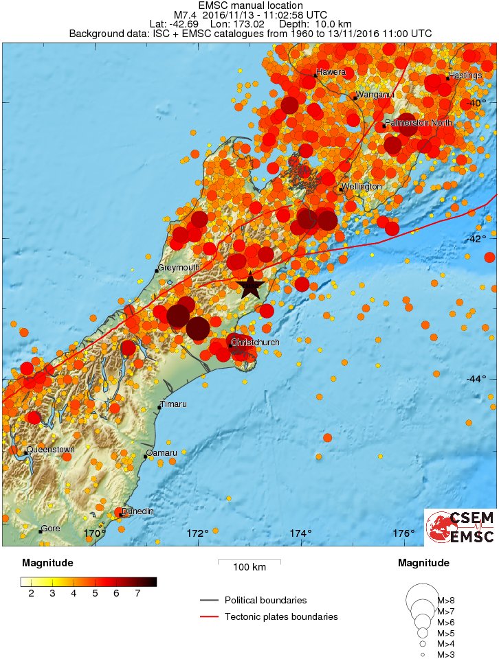
A major earthquake registered by the USGS as M7.8 hit near Christchurch, South Island, New Zealand at 11:02 UTC on November 13, 2016. The agency is reporting a depth of 10 km (6.2 miles). New Zealand's GEONET is reporting M7.5 at a depth of 16 km (9.9 miles). A tsunami warning has been issued. "People near the eastern coast of the South Island should immediately move to high ground or inland as far as possible," New Zealand's MCDEM said.
According to the USGS, the epicenter was located 53.8 km (33.5 miles) NE of Amberley (population 1 105), 77.6 km (48.2 miles) NNE of Kaiapoi (population 10 200), and 93 km (57.8 miles) NE of Christchurch (population 363 926), New Zealand.
This was a very complex earthquake that occurred both on land and at sea which is making it difficult to analyze.
There are 400 214 people living within 100 km (62 miles). About 10 000 people are living within 50 km (31 miles).
EMSC estimated there are 3.2 million people in the felt area.
Our reader from Christchurch, New Zealand said: "Slow, and long, like the rolling sea. We still have power in northeast Christchurch." She added: "We've had a few long rolling aftershocks. It was a 6.6 at Hanmer Springs. There have been a number of shocks set off elsewhere. Likely as a result of the Hanmer quake."
Another one, from Waikato (594 km / 369 miles from the epicenter) said: "Yip felt it in the Waikato area wtf we never feel earthquakes up here."
Hamilton (564 km / 351 miles) from the epicenter: "First time I've felt one in Hamilton, pretty scary."
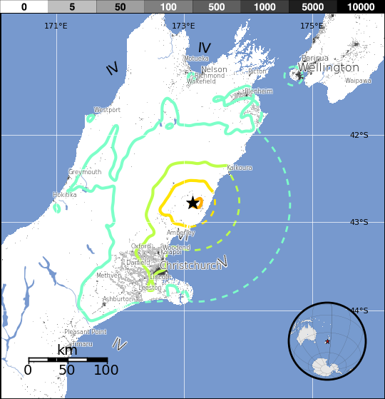
GEONET received more than 15 000 felt reports. "This quake was widely felt throughout New Zealand," the agency said.
"There have already been many aftershocks recorded, the largest has a magnitude of 6.2," it added.
Power outage and damage reports are coming in.
NWS NTWC said that earthquakes of this size are known to generate tsunamis potentially dangerous to coasts outside the source region. "This earthquake has the potential to generate a destructive tsunami in the source region."
From PTWC at 11:43 UTC:
PRELIMINARY EARTHQUAKE PARAMETERS
---------------------------------

  * MAGNITUDE      7.9
  * ORIGIN TIME    1103 UTC NOV 13 2016
  * COORDINATES    42.8 SOUTH  173.4 EAST
  * DEPTH          10 KM / 6 MILES
  * LOCATION       SOUTH ISLAND OF NEW ZEALAND

EVALUATION
----------

  * AN EARTHQUAKE WITH A PRELIMINARY MAGNITUDE OF 7.9 OCCURRED IN
    SOUTH ISLAND, NEW ZEALAND AT 1103 UTC ON SUNDAY NOVEMBER 13
    2016.

  * A DRAWDOWN OF 2.5 METERS WAS OBSERVED AT KAIKOURA TIDE STATION.

RECOMMENDED ACTIONS
-------------------
A DAMAGING LOCAL TSUNAMI MIGHT HAVE OCCURRED. APPROPRIATE ACTIONS
SHOULD BE TAKEN TO PROTECT LIVES AND PROPERTY.

TSUNAMI OBSERVATIONS
--------------------

  * THE FOLLOWING ARE TSUNAMI WAVE OBSERVATIONS FROM COASTAL
    AND/OR DEEP-OCEAN SEA LEVEL GAUGES AT THE INDICATED
    LOCATIONS. THE MAXIMUM TSUNAMI HEIGHT IS MEASURED WITH
    RESPECT TO THE NORMAL TIDE LEVEL.

                            GAUGE      TIME OF   MAXIMUM     WAVE
                         COORDINATES   MEASURE   TSUNAMI   PERIOD
    GAUGE LOCATION        LAT   LON     (UTC)     HEIGHT    (MIN)
    -------------------------------------------------------------
    KAIKOURA NZ          42.4S 173.7E    1103   2.49M/ 8.2FT  96
New Zealand's Ministry of Civil Defence (MCDEM) has issued a Tsunami Warning for all southern coastal areas of New Zealand:
National Warning: Tsunami Threat
No: 01
Issued 0050 hours 14 November 2016
The Ministry of Civil Defence & Emergency Management (MCDEM) has issued a tsunami warning for all southern coastal areas of New Zealand.
***A tsunami is possible***
The first wave activity may not be the most significant. Tsunami activity will continue for several hours and the threat must be regarded as real until this warning is canceled.
MCDEM is still assessing the threat and will provide more information within the next hour.
Meanwhile, people in coastal areas should:
1. Stay out of the water (sea, rivers and estuaries, including boating activities)
2. Stay off beaches and shore areas
3. Do not go sightseeing
4. Share this information with family, neighbours and friends
5. Listen to the radio and/or TV for updates
6. Follow instructions of local civil defense authorities
This warning will remain in effect until a cancellation message is issued by MCDEM.
"People near the eastern coast of the south island should immediately move to high ground or inland as far as possible. Take your getaway kit with you if possible. Do not travel into the areas at risk to get your kit or belongings. Take your pets with you if you can do so safely. Move immediately to the nearest higher ground, or as far inland as you can. If evacuation maps are present, follow the routes shown. Walk or bike if possible and drive only if essential. If driving, keep going once you are well outside the evacuation zone to allow room for others behind you. If you cannot escape the tsunami, go to an upper storey of a sturdy building or climb onto a roof or up a tree, or grab a floating object and hang on until help arrives. Boats are usually safer in water deeper than 20 meters than if they are on the shore. Move boats out to sea only if there is time and it is safe to do so. Never go to the shore to watch for a tsunami. Stay away from at-risk areas until the official all-clear is given. Listen to your local radio stations as emergency management officials will be broadcasting the most appropriate advice for your community and situation."
Only messages issued by MCDEM represent the official warning status for New Zealand. We note the Pacific Tsunami Warning Centre (PTWC) has issued a Tsunami Information Statement for this event. PTWC messages do not represent the official warning status for New Zealand.
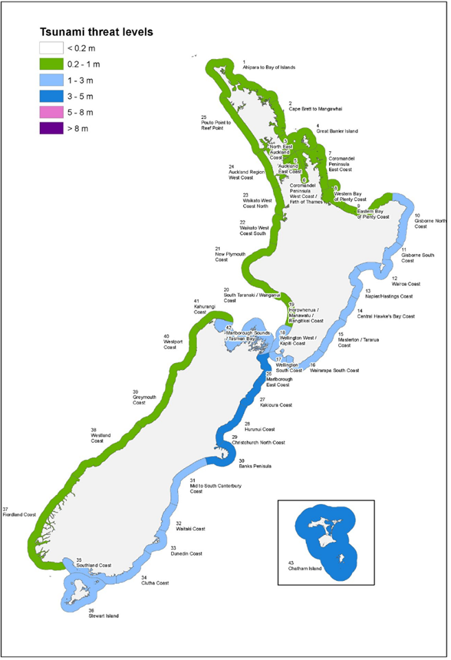
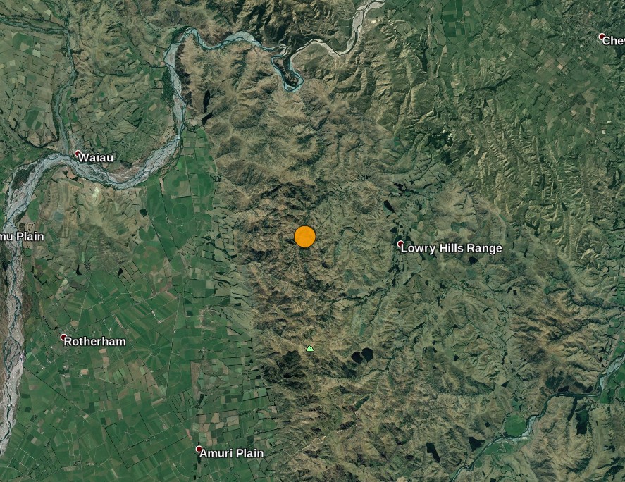
Image credit: Google
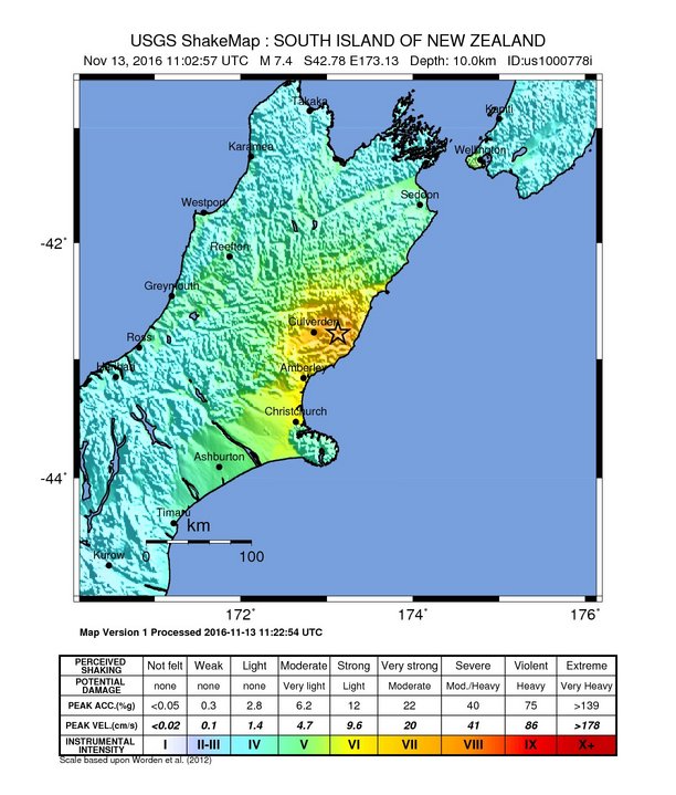
USGS issued a green alert level for shaking-related fatalities. There is a low likelihood of casualties.
Orange alert was issued for economic losses. Significant damage is likely and the disaster is potentially widespread. Estimated economic losses are less than 1% of GDP of New Zealand. Past events with this alert level have required a regional or national level response.
Estimated population exposure to earthquake shaking
#PorSiNoLoViste | Sismo de M7.8 sacudió la Isla Sur de Nueva Zelanda; se registró tsunami c/olas +3 m.
Vía @nzheraldpic.twitter.com/N0ApM9Pyyo— SkyAlert (@SkyAlertMx) November 13, 2016
"The sky went blue as the Earthquake hit – this is known to be due to an electric charge due to the plates shifting – incredible! Wellington has suffered damage and power outages," Wellington LIVE posted on their Facebook page.
Updates
17:44 UTC
At least 2 deaths have been reported. One heart attack and one killed in a building collapse.
Marlborough Civil Defence says there are reports of a train trapped just north of Kaikoura.
Marlborough Port is closed. This will affect all Cook Straight ferries.
Victoria University is currently closed.
Massey University Wellington Campus is currently closed.
November 16, 2016
Please see the following article for more updates:
New Zealand earthquake: One of the most complex ever recorded on land
Seismotectonics of the eastern margin of the Australia plate
The eastern margin of the Australia plate is one of the most seismically active areas of the world due to high rates of convergence between the Australia and Pacific plates. In the region of New Zealand, the 3000 km long Australia-Pacific plate boundary extends from south of Macquarie Island to the southern Kermadec Island chain. It includes an oceanic transform (the Macquarie Ridge), two oppositely verging subduction zones (Puysegur and Hikurangi), and a transpressive continental transform, the Alpine Fault through South Island, New Zealand.
Since 1900 there have been 15 M7.5+ earthquakes recorded near New Zealand. Nine of these, and the four largest, occurred along or near the Macquarie Ridge, including the 1989 M8.2 event on the ridge itself, and the 2004 M8.1 event 200 km to the west of the plate boundary, reflecting intraplate deformation. The largest recorded earthquake in New Zealand itself was the 1931 M7.8 Hawke's Bay earthquake, which killed 256 people. The last M7.5+ earthquake along the Alpine Fault was 170 years ago; studies of the faults' strain accumulation suggest that similar events are likely to occur again.
North of New Zealand, the Australia-Pacific boundary stretches east of Tonga and Fiji to 250 km south of Samoa. For 2,200 km the trench is approximately linear, and includes two segments where old (>120 Myr) Pacific oceanic lithosphere rapidly subducts westward (Kermadec and Tonga). At the northern end of the Tonga trench, the boundary curves sharply westward and changes along a 700 km-long segment from trench-normal subduction, to oblique subduction, to a left lateral transform-like structure.
Australia-Pacific convergence rates increase northward from 60 mm/yr at the southern Kermadec trench to 90 mm/yr at the northern Tonga trench; however, significant back arc extension (or equivalently, slab rollback) causes the consumption rate of subducting Pacific lithosphere to be much faster. The spreading rate in the Havre trough, west of the Kermadec trench, increases northward from 8 to 20 mm/yr. The southern tip of this spreading center is propagating into the North Island of New Zealand, rifting it apart. In the southern Lau Basin, west of the Tonga trench, the spreading rate increases northward from 60 to 90 mm/yr, and in the northern Lau Basin, multiple spreading centers result in an extension rate as high as 160 mm/yr. The overall subduction velocity of the Pacific plate is the vector sum of Australia-Pacific velocity and back arc spreading velocity: thus it increases northward along the Kermadec trench from 70 to 100 mm/yr, and along the Tonga trench from 150 to 240 mm/yr.
The Kermadec-Tonga subduction zone generates many large earthquakes on the interface between the descending Pacific and overriding Australia plates, within the two plates themselves and, less frequently, near the outer rise of the Pacific plate east of the trench. Since 1900, 40 M7.5+ earthquakes have been recorded, mostly north of 30°S. However, it is unclear whether any of the few historic M8+ events that have occurred close to the plate boundary were underthrusting events on the plate interface, or were intraplate earthquakes. On September 29, 2009, one of the largest normal fault (outer rise) earthquakes ever recorded (M8.1) occurred south of Samoa, 40 km east of the Tonga trench, generating a tsunami that killed at least 180 people.
Across the North Fiji Basin and to the west of the Vanuatu Islands, the Australia plate again subducts eastwards beneath the Pacific, at the North New Hebrides trench. At the southern end of this trench, east of the Loyalty Islands, the plate boundary curves east into an oceanic transform-like structure analogous to the one north of Tonga.
Australia-Pacific convergence rates increase northward from 80 to 90 mm/yr along the North New Hebrides trench, but the Australia plate consumption rate is increased by extension in the back arc and in the North Fiji Basin. Back arc spreading occurs at a rate of 50 mm/yr along most of the subduction zone, except near ~15°S, where the D'Entrecasteaux ridge intersects the trench and causes localized compression of 50 mm/yr in the back arc. Therefore, the Australia plate subduction velocity ranges from 120 mm/yr at the southern end of the North New Hebrides trench, to 40 mm/yr at the D'Entrecasteaux ridge-trench intersection, to 170 mm/yr at the northern end of the trench.
Large earthquakes are common along the North New Hebrides trench and have mechanisms associated with subduction tectonics, though occasional strike slip earthquakes occur near the subduction of the D'Entrecasteaux ridge. Within the subduction zone 34 M7.5+ earthquakes have been recorded since 1900. On October 7, 2009, a large interplate thrust fault earthquake (M7.6) in the northern North New Hebrides subduction zone was followed 15 minutes later by an even larger interplate event (M7.8) 60 km to the north. It is likely that the first event triggered the second of the so-called earthquake "doublet". (USGS) More information on regional seismicity and tectonics
The Watchers team and our contributors bring the latest on extreme weather, earthquakes, volcanic eruptions, space weather, and all things science. We're all about making sense of the natural world and keeping you informed on what’s happening. Got a tip or a question? Hit us up using the form at newstips!
Commenting rules and guidelines
We value the thoughts and opinions of our readers and welcome healthy discussions on our website. In order to maintain a respectful and positive community, we ask that all commenters follow these rules.