
Tropical Cyclone “Amos” expected to make landfall over Tutuila, American Samoa
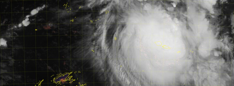
Image credit: JMA/HIMAWARI-8
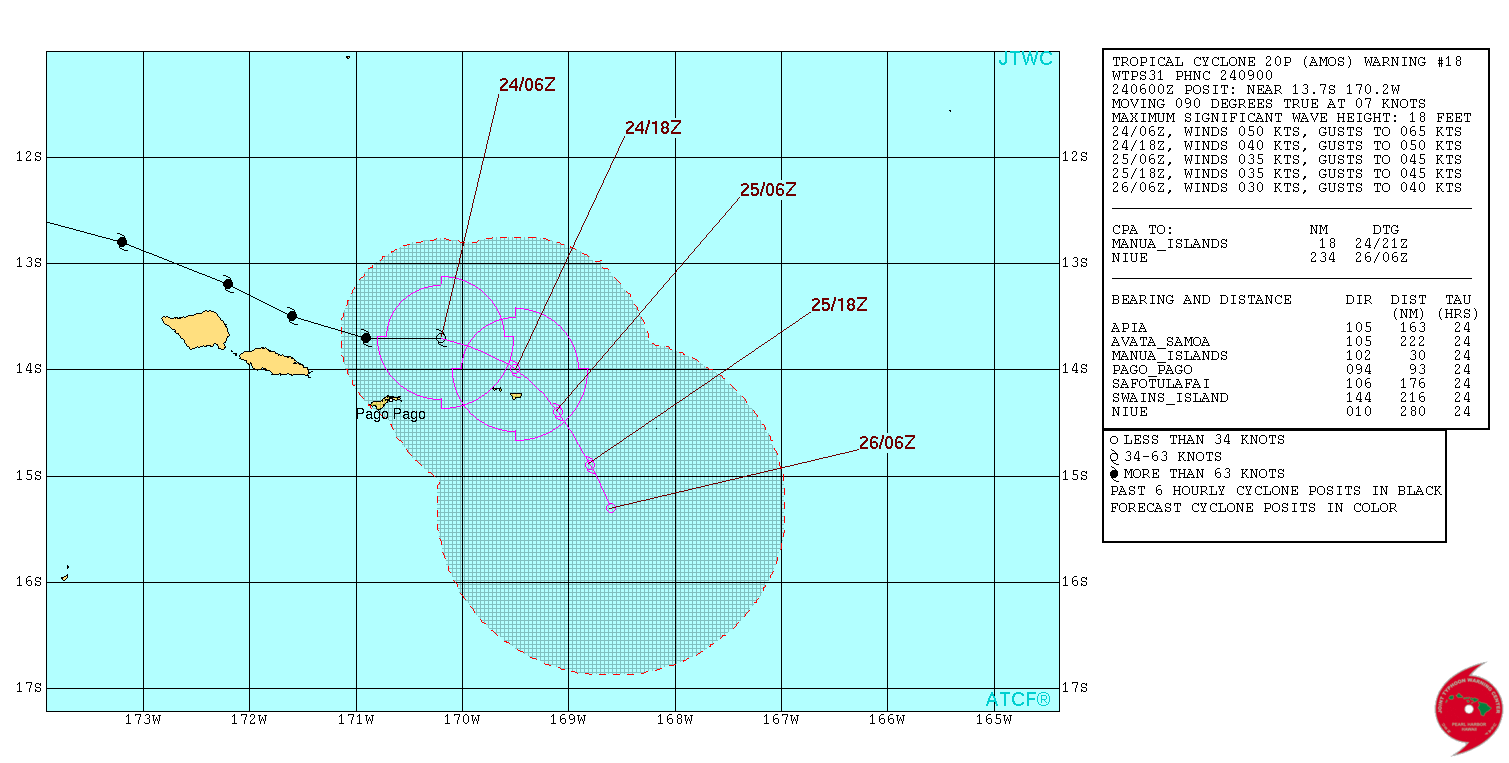
JTWC's forecast track for Tropical Cyclone "Amos" released 09:00 UTC on April 23 takes Amos just north of Upolu Island, Samoa early April 24 (UTC) and directly over Tutuila, American Samoa before 06:00 UTC on April 24. Potential impacts include river overflows, slippery roads, poor visibility, flooding, landslides and flying objects.
At 03:00 UTC on April 23, Amos' maximum sustained winds, as measured by JTWC, were 167 km/h (103 mph). Wind gusts were reaching 203 km/h (126 mph). This made Amos equivalent to a Category 2 (upper edge) hurricane on the Saffir-Simpson Hurricane Wind Scale. Amos is still intensifying and is expected to become a major hurricane in a couple of hours.
At the time, the system was expected to pass over Upolu Island, Samoa. However, by 09:00 UTC, Amos has accelerated east-southeastward under the steering influence of a near-equatorial ridge to the north and east.
#CycloneAmos changed track, expected to make landfall over #Tutuila #AmericanSamoa https://t.co/HtoRfdGVP3 pic.twitter.com/IWibOCZtUE
— The Watchers (@TheWatchers_) April 23, 2016
This recent change in storm motion has resulted in a significant eastward shift in the anticipated track, which now takes the system over Tutuila, American Samoa within the next 24 hours.
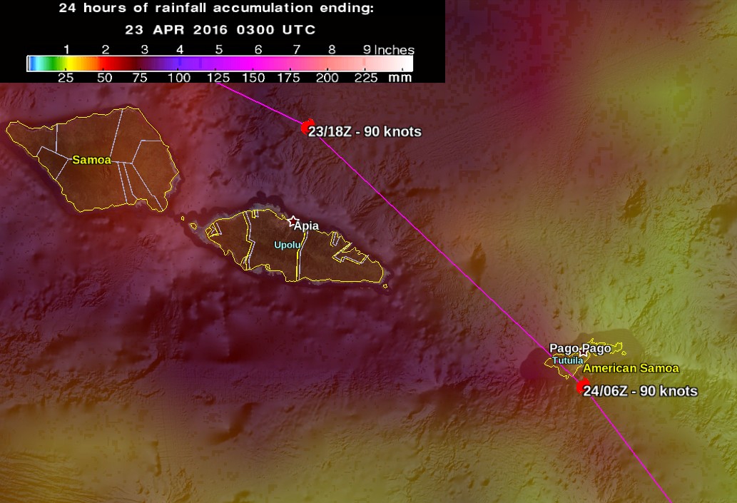
Tropical Cyclone "Amos" – JTWC's forecast track at 09:00 UTC on April 23, 2016, with 24 hours of rainfall accumulation as measured by NASA/JAXA GPM
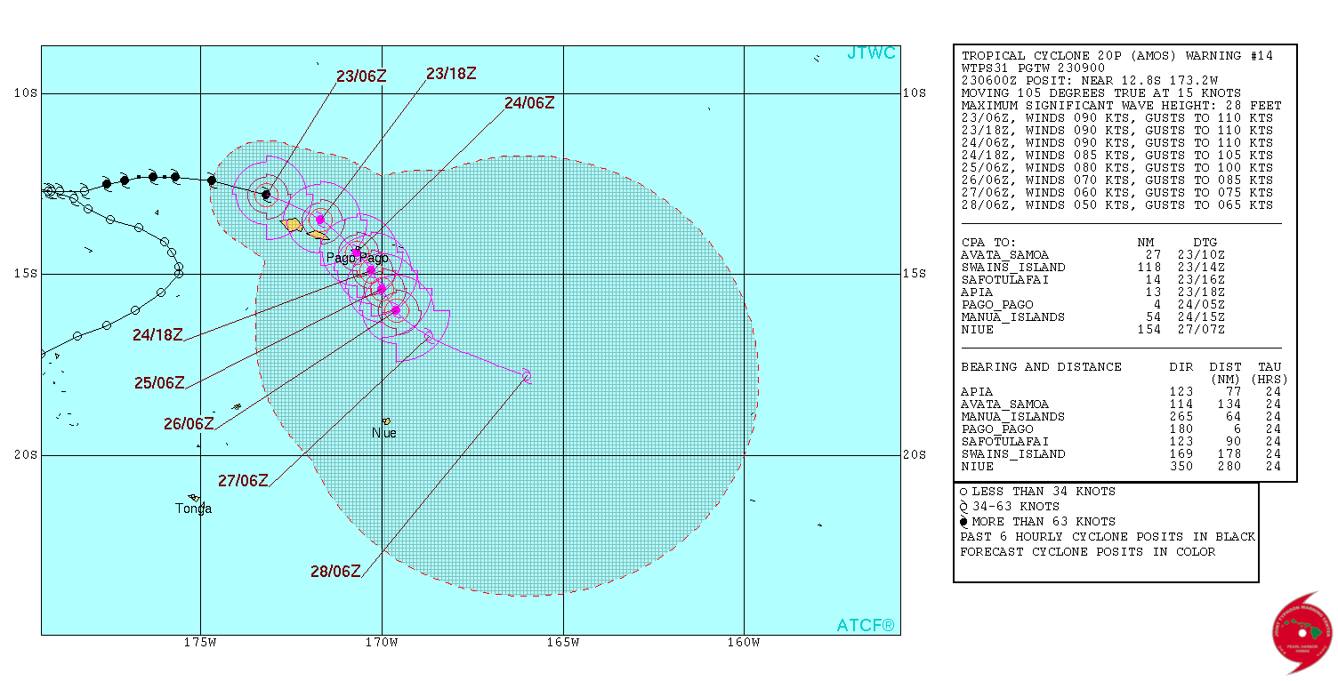
Tropical Cyclone "Amos" forecast track by JTWC at 09:00 UTC on April 23, 2016
Tropical Cyclone "Amos" at 08:10 UTC on April 23, 2016. Credit: JMA/Himawari
According to Samoa Meteorological Services, Amos was located about 94 km (52 miles) northwest of Asau or 190 km (118 miles) northwest of Apia at 04:00 UTC on April 23. The system continues to move southeastward toward Samoa at a speed of 32 km/h (20 mph).
The agency warned that periods rain, heavy at times with thunderstorms are expected throughout the islands. Expected storm surge is 4.2 – 4.8 m (14 – 16 feet) and developing to 4.6 – 5.5 m (15 – 18 feet). Seas will be very rough and storm surge of 5.5 m – 6 m (18 – 20 feet) will affect open seas.
Potential impacts are river overflows, slippery roads, poor visibility, flooding, landslides and flying objects.
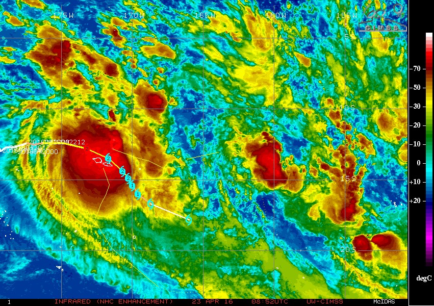
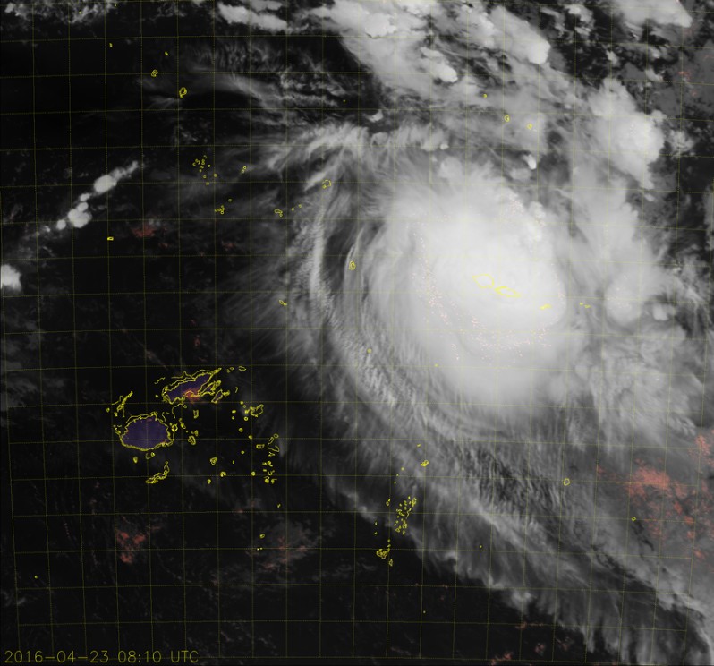
Tropical Cyclone "Amos" – Infrared image (NHC Enhancement) 08:52 UTC on April 23, 2016. Credit: UW-CIMSS
NWS Pago Pago, American Samoa issued a Hurricane Watch, Tropical Storm Warning, High Surf Warning and a Flash Flood Watch for all American Samoa.
Coastal inundation of prone communities is possible. All residents living on prone shorelines can expect some water incursion into their homes. Those in typically flood prone areas may have a foot or two of water in their homes, causing minor damage. Shoreline roads may briefly close with up to two feet of water across, except those in flood prone areas which could have upwards of 4 to 5 feet of water across them. Moderate beach erosion is possible, becoming likely if conditions extend through multiple high tide cycles.
Conditions will be worsened by battering waves. Such waves will increase the likelihood of property damage, especially to structures on or very near the shoreline.
Hurricane storm force winds and gusts are currently forecast to begin affecting the area around Saturday evening (local time, 11 hours ahead UTC) into Saturday night.
Hazardous surfs generated by Amos will impact southwest through the north facing shores of all islands of American Samoa.
#CycloneAmos over #SamoanIslands – Maximum winds at 15:00 UTC: 90 kt (167 km/h / 103 mph) pic.twitter.com/l3rk1Rjarr
— The Watchers (@TheWatchers_) April 23, 2016
Update, April 24, 11:16 UTC
The Samoa meteorology service says the impact of tropical cyclone Amos was not as powerful as earlier feared. Instead of a southeast path, Amos more or less continued on an easterly path and fortunately the wind strength was not as severe.
There was, however, a lot of flooding across the country but most of the impact is mainly from the high surf due to swells and rainfall. Some says roads have been flooded and in some cases washed away. The damage is being assessed.
NWS Pago Pago, American Samoa said Flash Flood Watch remains in effect. "The system is now moving towards Manu'a and they expect the winds to pick up there throughout today, and then they will see where the system will move from there."
Officials have advised people to be careful and remain indoors. (RNZ)
At 09:00 UTC today, Amos' maximum sustained winds were 92.6 km/h (57.5 mph).
Tropical Cyclone "Amos" forecast track by JTWC at 09:00 UTC on April 24, 2016
I'm a dedicated researcher, journalist, and editor at The Watchers. With over 20 years of experience in the media industry, I specialize in hard science news, focusing on extreme weather, seismic and volcanic activity, space weather, and astronomy, including near-Earth objects and planetary defense strategies. You can reach me at teo /at/ watchers.news.
Calm at the moment. Had high winds several hours ago with light rain. The winds subsided at approximately 5am but light rain continues to fall.
Thanks for the update Jer. Where are you located?