
Huge magma chamber discovered deep beneath the Yellowstone supervolcano
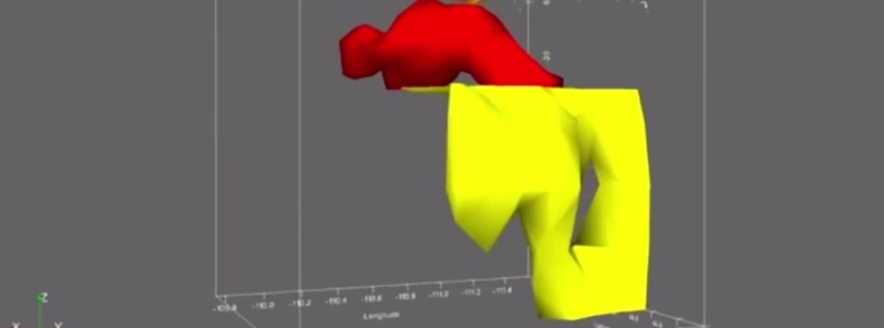
Image credit: University of Utah
A team of University of Utah seismologists discovered and made images of a reservoir of hot, partly molten rock about 19 to 45 km (12 to 28 miles) beneath the Yellowstone supervolcano, and it is 4.4 times larger than the shallower, long-known magma chamber.
The hot rock in the newly discovered, deeper magma reservoir would fill the 1 000-cubic-mile Grand Canyon 11.2 times, while the previously known magma chamber would fill the Grand Canyon 2.5 times, says postdoctoral researcher Jamie Farrell, a co-author of the study published yesterday in the journal Science.
“For the first time, we have imaged the continuous volcanic plumbing system under Yellowstone,” says first author Hsin-Hua Huang, also a postdoctoral researcher in geology and geophysics. “That includes the upper crustal magma chamber we have seen previously plus a lower crustal magma reservoir that has never been imaged before and that connects the upper chamber to the Yellowstone hotspot plume below.”
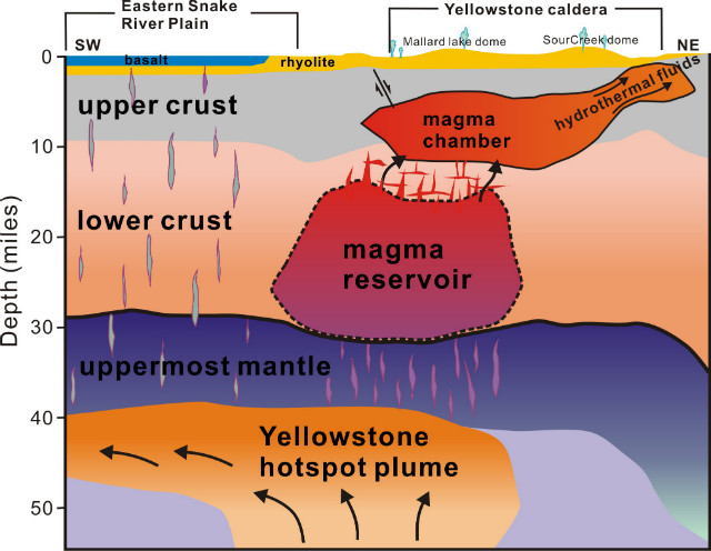
Image credit: Hsin-Hua Huang, University of Utah
Contrary to popular perception, the magma chamber and magma reservoir are not full of molten rock. Instead, the rock is hot, mostly solid and spongelike, with pockets of molten rock within it. Huang says the new study indicates the upper magma chamber averages about 9 percent molten rock – consistent with earlier estimates of 5 to 15 percent melt – and the lower magma reservoir is about 2 percent melt.
This brief animated video shows the Yellowstone supervolcano’s underground plumbing system – including the newly discovered magma reservoir:
No increase in the danger
The researchers emphasize that Yellowstone’s plumbing system is no larger – nor closer to erupting – than before, only that they now have used advanced techniques to make a complete image of the system that carries hot and partly molten rock upward from the top of the Yellowstone hotspot plume – about 40 miles beneath the surface – to the magma reservoir and the magma chamber above it.
“The magma chamber and reservoir are not getting any bigger than they have been, it’s just that we can see them better now using new techniques,” Farrell says.
Study co-author Fan-Chi Lin, an assistant professor of geology and geophysics, says: “It gives us a better understanding the Yellowstone magmatic system. We can now use these new models to better estimate the potential seismic and volcanic hazards.”
The researchers point out that the previously known upper magma chamber was the immediate source of three cataclysmic eruptions of the Yellowstone caldera 2 million, 1.2 million and 640 000 years ago, and that isn’t changed by discovery of the underlying magma reservoir that supplies the magma chamber.
“The actual hazard is the same, but now we have a much better understanding of the complete crustal magma system,” says study co-author Robert B. Smith, a research and emeritus professor of geology and geophysics at the University of Utah.
The three supervolcano eruptions at Yellowstone – on the Wyoming-Idaho-Montana border – covered much of North America in volcanic ash. A supervolcano eruption today would be cataclysmic, but Smith says the annual chance is 1 in 700 000.
Before the new discovery, researchers had envisioned partly molten rock moving upward from the Yellowstone hotspot plume via a series of vertical and horizontal cracks, known as dikes and sills, or as blobs. They still believe such cracks move hot rock from the plume head to the magma reservoir and from there to the shallow magma chamber.
A better, deeper look at Yellowstone
As with past studies that made images of Yellowstone’s volcanic plumbing, the new study used seismic imaging, which is somewhat like a medical CT scan but uses earthquake waves instead of X-rays to distinguish rock of various densities. Quake waves go faster through cold rock, and slower through hot and molten rock.
For the new study, Huang developed a technique to combine two kinds of seismic information: Data from local quakes detected in Utah, Idaho, the Teton Range and Yellowstone by the University of Utah Seismograph Stations and data from more distant quakes detected by the National Science Foundation-funded EarthScope array of seismometers, which was used to map the underground structure of the lower 48 states.
The Utah seismic network has closely spaced seismometers that are better at making images of the shallower crust beneath Yellowstone, while EarthScope’s seismometers are better at making images of deeper structures.
“It’s a technique combining local and distant earthquake data better to look at this lower crustal magma reservoir,” Huang says.
Source: University of Utah
The study in Science is titled, “The Yellowstone magmatic system from the mantle plume to the upper crust.” Huang, Lin, Farrell and Smith conducted the research with Brandon Schmandt at the University of New Mexico and Victor Tsai at the California Institute of Technology. Funding came from the University of Utah, National Science Foundation, Brinson Foundation and William Carrico.
The Watchers team and our contributors bring the latest on extreme weather, earthquakes, volcanic eruptions, space weather, and all things science. We're all about making sense of the natural world and keeping you informed on what’s happening. Got a tip or a question? Hit us up using the form at newstips!
NOW YORK CITY