
Very strong and shallow earthquake M 6.5 struck off the coast of Aisen, Chile
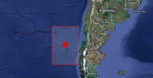
Image credit: ©2013 TerraMetrics, Map Data ©2013 Google
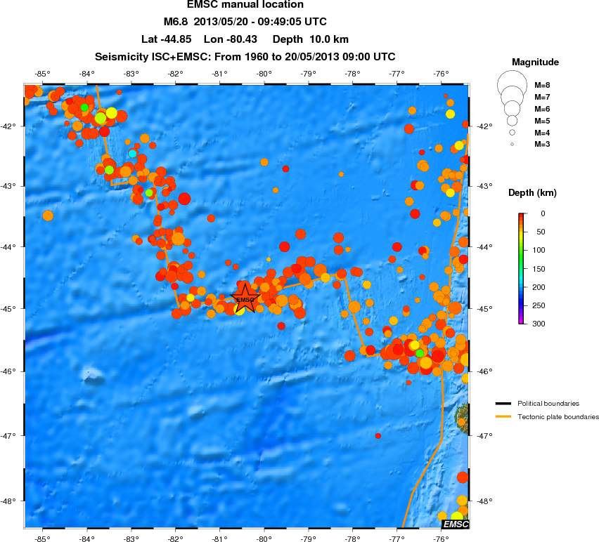
A very strong and shallow earthquake M 6.8 (preliminary data) struck off the coast of Aisen, Chile on May 20, 2013 at 09:49 UTC. Epicenter of the earthquake was located 597km (371mi) WSW of Puerto Quellon, Chile and 606km (377mi) WSW of Chonchi, Chile at coordinates 44.927°S 80.639°W. Depth of the earthquake is being reported shallow at 10 km by both USGS and EMSC. This report is based on preliminary data.
EMSC and USGS lovered the magnitude to 6.5.
GDACS reported this earthquake can have a low humanitarian impact based on the magnitude and the affected population and their vulnerability.
There are no people living within 100 km of the earthquake.
NOAA reported:
No destructive widespread tsunami threat exists based on historical earthquake and tsunami data.
However, earthquakes of this size sometimes generate local tsunamis that can be destructive along coasts located within a hundred kilometers of the earthquake epicenter. Authorities in the region of the epicenter should be aware of this possibility and take appropriate action.
Tectonic summary by USGS
Seismotectonics of South America (Nazca Plate Region)
The South American arc extends over 7,000 km, from the Chilean margin triple junction offshore of southern Chile to its intersection with the Panama fracture zone, offshore of the southern coast of Panama in Central America. It marks the plate boundary between the subducting Nazca plate and the South America plate, where the oceanic crust and lithosphere of the Nazca plate begin their descent into the mantle beneath South America.
The convergence associated with this subduction process is responsible for the uplift of the Andes Mountains, and for the active volcanic chain present along much of this deformation front. Relative to a fixed South America plate, the Nazca plate moves slightly north of eastwards at a rate varying from approximately 80 mm/yr in the south to approximately 65 mm/yr in the north. Although the rate of subduction varies little along the entire arc, there are complex changes in the geologic processes along the subduction zone that dramatically influence volcanic activity, crustal deformation, earthquake generation and occurrence all along the western edge of South America.
Most of the large earthquakes in South America are constrained to shallow depths of 0 to 70 km resulting from both crustal and interplate deformation. Crustal earthquakes result from deformation and mountain building in the overriding South America plate and generate earthquakes as deep as approximately 50 km. Interplate earthquakes occur due to slip along the dipping interface between the Nazca and the South American plates. Interplate earthquakes in this region are frequent and often large, and occur between the depths of approximately 10 and 60 km.
Since 1900, numerous magnitude 8 or larger earthquakes have occurred on this subduction zone interface that were followed by devastating tsunamis, including the 1960 M9.5 earthquake in southern Chile, the largest instrumentally recorded earthquake in the world. Other notable shallow tsunami-generating earthquakes include the 1906 M8.5 earthquake near Esmeraldas, Ecuador, the 1922 M8.5 earthquake near Coquimbo, Chile, the 2001 M8.4 Arequipa, Peru earthquake, the 2007 M8.0 earthquake near Pisco, Peru, and the 2010 M8.8 Maule, Chile earthquake located just north of the 1960 event… Read more here.
Commenting rules and guidelines
We value the thoughts and opinions of our readers and welcome healthy discussions on our website. In order to maintain a respectful and positive community, we ask that all commenters follow these rules.