
Two strong and shallow earthquakes with magnitudes 6.2 and 6.9 struck Gulf of California
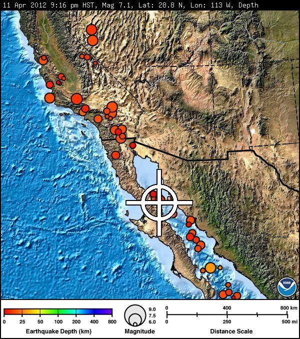
Image credit: TW
Two strong and shallow earthquakes struck Gulf of California on April 12, 2012. First earthquake was measured with magnitude 6.2 at 07:06:01 UTC with depth of 10.1km. A second earthquake struck same area less than 10 minutes later, at 07:15:49 UTC, recorded magnitude was 6.9 with depth at 10.3km.
NO tsunami warning, watch or advisory is in effect for these areas.
The set of earthquakes in the Gulf of California have started with a M4.7 earthquake, followed 18 minutes later by a M6.2 earthquake and another 9 minutes later with a M6.9 earthquake (the most powerful so far)
USGS has calculated that 3000 people will have experienced a very strong shaking and that 105,000 have experienced a strong shaking. Both these areas are at risk for eventual damage, especially because 9 minutes earlier another very strong earthquake struck the same area.
The Mexican Servico Sismologico Nacional reports a magnitude of 6.8 with an epicenter below land. USGS hypocenter is at M6.9 and off the coast.
Epicentral area is very sparsely populated with only a few houses along the coastline apart from Santa Isabel.
Although it is a ridge earthquake, the epicenter of the M6.9 quake looks to be very close to the coast which makes this earthquake (the second very strong in a matter of 9 minutes) EXTREMELY DANGEROUS for shaking damage and fatalities. Let us hope that we are too pessimistic here. The kind of shaking will depend on the focal mechanism.
Following calculations by the USGS (providing that the earthquake data are correct) a MMI VII will have been experienced on the Baja California peninsula ! This means dangerous for the coastal areas experiencing this kind of shaking.
Updates will be posted accordingly.
| Magnitude | 6.2 |
|---|---|
| Date-Time |
|
| Location | 28.841°N, 113.072°W |
| Depth | 10.1 km (6.3 miles) |
| Region | GULF OF CALIFORNIA |
| Distances | 142 km (88 miles) NE of Guerrero Negro, Baja Calif. Sur, Mexico 182 km (113 miles) NNW of Santa Rosalia, Baja Calif. Sur, Mexico 207 km (128 miles) W of Hermosillo, Sonora, Mexico 519 km (322 miles) S of PHOENIX, Arizona |
| Location Uncertainty | horizontal +/- 17.3 km (10.7 miles); depth +/- 2.7 km (1.7 miles) |
| Parameters | NST=372, Nph=372, Dmin=187 km, Rmss=1.56 sec, Gp=104°, M-type=regional moment magnitude (Mw), Version=8 |
| Source |
|
| Event ID | usc000919m |

| Magnitude | 6.9 |
|---|---|
| Date-Time |
|
| Location | 28.790°N, 113.142°W |
| Depth | 10.3 km (6.4 miles) |
| Region | GULF OF CALIFORNIA |
| Distances | 133 km (82 miles) NE of Guerrero Negro, Baja Calif. Sur, Mexico 179 km (111 miles) NNW of Santa Rosalia, Baja Calif. Sur, Mexico 215 km (133 miles) W of Hermosillo, Sonora, Mexico 526 km (326 miles) SSW of PHOENIX, Arizona |
| Location Uncertainty | horizontal +/- 18.1 km (11.2 miles); depth +/- 4.1 km (2.5 miles) |
| Parameters | NST=331, Nph=331, Dmin=216 km, Rmss=1.32 sec, Gp=162°, M-type=regional moment magnitude (Mw), Version=D |
| Source |
|
| Event ID | usc00091a1 |

Indepth info and reports here.
I'm a dedicated researcher, journalist, and editor at The Watchers. With over 20 years of experience in the media industry, I specialize in hard science news, focusing on extreme weather, seismic and volcanic activity, space weather, and astronomy, including near-Earth objects and planetary defense strategies. You can reach me at teo /at/ watchers.news.
Commenting rules and guidelines
We value the thoughts and opinions of our readers and welcome healthy discussions on our website. In order to maintain a respectful and positive community, we ask that all commenters follow these rules.