
Atlantic winds: Nate, Maria, Lee & Kate
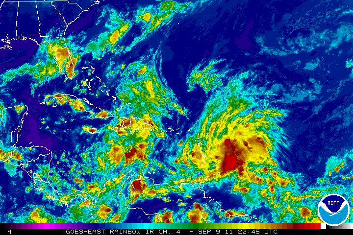
Image credit: TW
Tropical Storm Nate
Tropical Storm Nate formed in the Bay of Campeche on September 7, 2011. Nate remained a tropical storm two days later. At 1:00 p.m. Central Daylight Time (CDT) on September 9, the U.S. National Hurricane Center (NHC) reported that Nate had maximum sustained winds of 50 miles (85 kilometers) per hour. The storm was located about 150 miles (240 kilometers) west of Campeche.

As of September 9, a hurricane watch was in effect for Mexico from Tampico to Veracruz, and a tropical storm watch was in effect for Veracruz to Punta el Lagarto, and Tampico to La Cruz. Hurricane hunter aircraft, however, found the storm had weakened as it moved toward the west-southwest.
Tropical Storm Nate Advisory Archive
Upwelling, dry air and proximity to land were limiting the intensity of Nate. When a storm sits over the same area in water, wave action brings colder water up from the depths. Since tropical systems need warm water to survive, the cold water leads to weakening.
Dry air was wrapping around from the desert-like areas of Texas and Mexico, and being drawn into the circulation. The dry air was cutting off the storm’s moisture supply. Nate is so close to land in Mexico, that it is disrupting the wind flow of the storm. This is bad news for Texas and good and bad news for parts of Mexico. (AccuWeather)
| ...NATE STATIONARY AGAIN…EXPECTED TO MOVE WESTWARD TOWARD THE SOUTHWEST GULF COAST OF MEXICO THIS WEEKEND... (NationalHurricaneCenter) | |||||||
| 4:00 PM CDT Fri Sep 9 Location: 20.0°N 92.8°W Max sustained: 50 mph Moving: Stationary Min pressure: 998 mb | Public Advisory #9 400 PM CDT | Aviso Publico none issued in last 12 hrs | Forecast/ Advisory #9 2100 UTC | Forecast Discussion #9 400 PM CDT | Wind Speed Probabilities #9 2100 UTC | ||


Satellite Animations
- Storm-Centered Infrared (GOES 12; NOAA/SSD)
- Storm-Centered Infrared (Aviation Color Enhancement) (GOES 12; NOAA/SSD)
- Storm-Centered Water Vapor (GOES 12; NOAA/SSD)
- Storm-Centered Visible (GOES 12; NOAA/SSD)
- Storm-Centered Visible (Colorized) (GOES 12; NOAA/SSD)
- Gulf of Mexico Infrared (GOES 12; NOAA/SSD)
- Gulf of Mexico Infrared (Aviation Color Enhancement) (GOES 12; NOAA/SSD)
- Gulf of Mexico Water Vapor (GOES 12; NOAA/SSD)
- Gulf of Mexico Visible (GOES 12; NOAA/SSD)
- Gulf of Mexico Visible (Colorized) (GOES 12; NOAA/SSD)
Tropical storm Maria
The forward speed of Maria has slowed, but wind shear is negatively affecting the storm. This should prevent any rapid strengthening this weekend, although some fluctuations in intensity can occur.
The system should be influenced by the rim of Atlantic high pressure and re-curve out to the northeast before reaching the U.S. later next week. Maria is expected to track farther west than Katia, but east of Irene. Maria could still interact with other weather systems to the west, such as a front or trough of low pressure. Such a setup contributed to the heavy rainfall in the mid-Atlantic this week.
Maria will bring rough seas, bursts of heavy rain and gust winds across the Leewards, British and U.S Virgin Islands and into Puerto Rico this weekend. Next up for tropical storm conditions would be the Turks and Caicos Islands and part of the Bahamas early next week. (AccuWeather)
| …RAIN BANDS FROM MARIA MOVING ACROSS THE LESSER ANTILLES…(NationalHurricaneCenter) | |||||||
| 5:00 PM AST Fri Sep 9 Location: 14.8°N 58.6°W Max sustained: 45 mph Moving: NW at 16 mph Min pressure: 1004 mb | Public Advisory #13 500 PM AST | Aviso Publico último boletín | Forecast/ Advisory #13 2100 UTC | Forecast Discussion #13 500 PM AST | Wind Speed Probabilities #13 2100 UTC | ||
| NWS Local Statements | US Watch/ Warning 500 PM AST | ||||||


Satellite Animations
- Storm-Centered Infrared (GOES 12; NOAA/SSD)
- Storm-Centered Infrared (Aviation Color Enhancement) (GOES 12; NOAA/SSD)
- Storm-Centered Water Vapor (GOES 12; NOAA/SSD)
- Storm-Centered Visible (GOES 12; NOAA/SSD)
- Storm-Centered Visible (Colorized) (GOES 12; NOAA/SSD)
- West Atlantic Infrared (GOES 12; NOAA/SSD)
- West Atlantic Infrared (Aviation Color Enhancement) (GOES 12; NOAA/SSD)
- West Atlantic Water Vapor (GOES 12; NOAA/SSD)
- West Atlantic Visible (GOES 12; NOAA/SSD)
- West Atlantic Visible (Colorized) (GOES 12; NOAA/SSD)
Hurricanes Lee & Katia
One week after Hurricane Irene battered the East Coast of the United States with damaging winds and flooding rain, a less-touted, plodding storm system soaked the eastern half of the country with more rain than its predecessor, and over a wider area. Tropical Storm Lee had a short official life as a named storm, but its effects lasted nearly a week.
Officially declared a tropical storm late on September 2, Lee reached its peak sustained winds of 57 miles (92 kilometers) per hour—well below hurricane force—on September 3 before making landfall on the Gulf Coast. By September 5, the storm was no longer a tropical depression, yet it was only beginning its march from Louisiana to soggy New England and the Mid-Atlantic.

As Lee moved north and east, it merged with a stalled frontal system. Meanwhile, Hurricane Katia was pushing north and west over the Atlantic, and blocking Lee from quickly moving east and offshore. The two storms aligned to pull copious amounts of moisture from the Gulf of Mexico and the Atlantic.
A meteorologist with the National Weather Service in Binghamton, New York, summed it up this way on September 7:
{There is a > bad combo of ingredients in place to continue very heavy rainfall. A closed upper low continues to spin over the Ohio Valley, with a deep southerly fetch along the eastern seaboard, only adding to the moisture in place from the remains of Tropical Storm Lee. Water vapor loops show tropical moisture from distant Hurricane Katia getting steered all the way into the rain area.
| …KATIA A LARGE HURRICANE OVER THE OPEN NORTH ATLANTIC… | |||||||
| 5:00 PM AST Fri Sep 9 Location: 40.6°N 62.7°W Max sustained: 85 mph Moving: ENE at 38 mph Min pressure: 970 mb | Public Advisory #47 500 PM AST | Aviso Publico none issued in last 12 hrs | Forecast/ Advisory #47 2100 UTC | Forecast Discussion #47 500 PM AST | Wind Speed Probabilities #47 2100 UTC | ||


The U.K. and parts of Northwest Europe will feel the wrath of Katia by the start of next week.
Hurricane Katia will sweep across the North Atlantic Ocean Saturday, then clip the British Archipelago as it becomes a powerful extratropical storm Sunday night to Tuesday. Katia’s gales and slashing rain will overspread Ireland and Scotland late Sunday and early Monday, persisting through Tuesday. Hurricane gusts will be possible, with the greatest threat along northern shores and over hills.
Strong winds with gale-force gusts will also whip England and Wales, where some rain will also fall.
On the European mainland, northernmost France through the Netherlands and Denmark will be windswept with some rain owing to Katia. But western Norway will fare worse, having gales and drenching rainfall early next week.
Prior to crossing the cold waters of the North Atlantic, Katia will pass well to the east of Nova Scotia and Newfoundland, Canada Friday and Friday night. (AccuWeather)

Later on Sunday and into Monday, post Tropical Storm Katia is expected to approach the UK, bringing the risk of severe gales and storm force winds in places. The predicted high winds could coincide with high tides and western coasts in particular could be at risk from localised flooding. (MetOffice)

Satellite Animations
- Storm-Centered Infrared (GOES 12; NOAA/SSD)
- Storm-Centered Infrared (Aviation Color Enhancement) (GOES 12; NOAA/SSD)
- Storm-Centered Water Vapor (GOES 12; NOAA/SSD)
- Storm-Centered Visible (GOES 12; NOAA/SSD)
- Storm-Centered Visible (Colorized) (GOES 12; NOAA/SSD)
- Northwest Atlantic Infrared (GOES 12; NOAA/SSD)
- Northwest Atlantic Infrared (Aviation Color Enhancement) (GOES 12; NOAA/SSD)
- Northwest Atlantic Water Vapor (GOES 12; NOAA/SSD)
- Northwest Atlantic Visible (GOES 12; NOAA/SSD)
- Northwest Atlantic Visible (Colorized) (GOES 12; NOAA/SSD)
- NHC issuing advisories on Hurricane KATIA, TS MARIA and TS NATE
- HPC issuing advisories on LEE
- September issue of the monthly Q & A with NHC professionals is available
- Check the Tropical Cyclone Preparedness Guide (PDF) for preparedness tips
Commenting rules and guidelines
We value the thoughts and opinions of our readers and welcome healthy discussions on our website. In order to maintain a respectful and positive community, we ask that all commenters follow these rules.