
Severe thunderstorms, large hail and tornadoes target portions of the Midwest, U.S.

Image credit: NWS/WPC
Severe weather, including strong winds, large hail and strong tornadoes, is expected to impact the Midwest on May 21, 2024, particularly affecting Iowa, Missouri, Wisconsin, and Illinois. A Moderate Risk (Level 4 of 5) of severe thunderstorms has been issued for these regions. The risk of severe storms across the country are expected to continue into late week.
Severe weather is forecasted to impact the Midwest on May 21, 2024, with a Moderate Risk (Level 4 of 5) issued for portions of Iowa, Missouri, Wisconsin, and Illinois.
This significant weather event is expected to produce damaging winds, large hail, and strong tornadoes, particularly affecting major cities such as Des Moines, Cedar Rapids, Davenport, and Waterloo in Iowa, as well as St. Joseph in Missouri. Some 4 million people are living in areas with Level 4 of 5 risks of severe weather today.
Meteorologists have warned that the atmosphere will become highly unstable ahead of a sweeping cold front, creating favorable conditions for severe thunderstorms. These storms are expected to generate multiple tornadoes, with Iowa identified as having the highest likelihood of experiencing these powerful tornadoes due to the presence of significant wind shear.
“We see the concern for dozens of tornadoes across parts of the central U.S. through Tuesday night, and some of this is going to be after dark,” AccuWeather Chief Meteorologist Jon Porter said. “Whenever you have severe thunderstorms, especially destructive winds and a tornado threat after dark, that’s especially dangerous because tornadoes at night are two times more likely to produce fatalities than tornadoes that happen at other times of the day.”
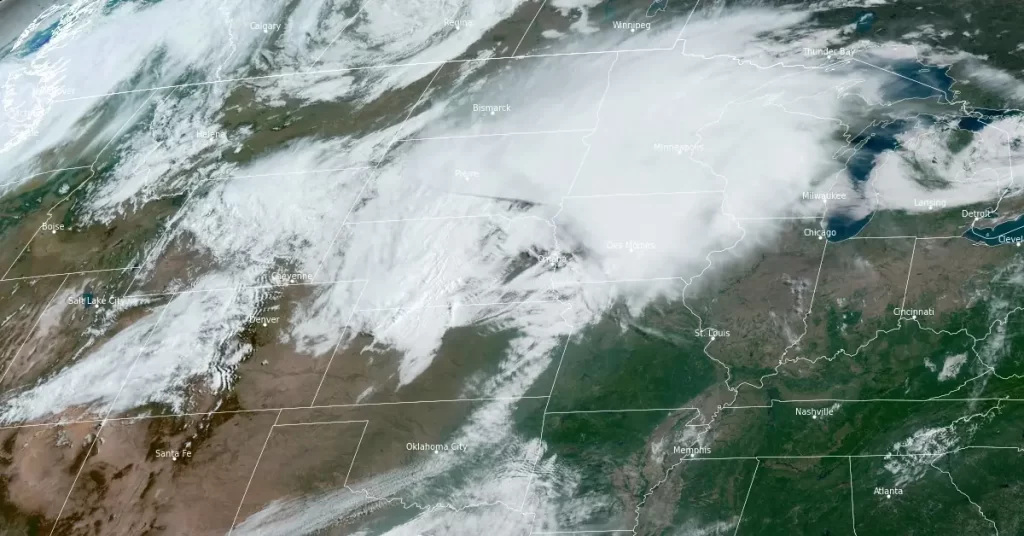
The National Weather Service (NWS) forecasters Kong and Snell noted at 04:00 EDT (08:00 UTC) on May 21, 2024, that a persistent weather pattern is driving energetic and fast-moving systems from the Pacific Ocean into the Northwest. These systems are expected to intensify as they move into the central Plains, tracking northeast across the central Plains and expanding toward the upper Midwest by tonight. The increasing windy conditions and severe weather threat will accompany this deep and intense low-pressure system.
A Severe Thunderstorm Watch has been issued for central and southern Iowa until early Tuesday afternoon. Thunderstorms ahead of the potent cold front may contain damaging wind gusts, large hail, and a few tornadoes from the central Plains to the Great Lakes, particularly over Iowa where the Storm Prediction Center has issued a Moderate Risk of severe thunderstorms.
Additionally, heavy rainfall may lead to instances of flash flooding across the upper Midwest through the night. As the system moves into southern Canada by Wednesday morning, May 22, the threat of heavy rain will decrease across the Great Lakes, although winds will remain strong for a while.
As the low-pressure system shifts, the trailing cold front is expected to become nearly stationary across the southern Plains, leading to a new phase of severe weather and excessive rainfall. This threat is anticipated to expand toward the mid-Mississippi Valley by Wednesday night, with thunderstorms becoming slow-moving in this area.
References:
1 Short Range Forecast Discussion – NWS WPC – College Park MD 400 AM EDT Tue May 21 2024
2 Severe weather outbreak expected to spawn strong tornadoes across Midwest on Tuesday – FOX Weather – May 21, 2024
3 ‘Dozens of tornadoes likely’ Tuesday as week-long severe weather threat kicks off – AccuWeather – May 20/21, 2024
I'm a dedicated researcher, journalist, and editor at The Watchers. With over 20 years of experience in the media industry, I specialize in hard science news, focusing on extreme weather, seismic and volcanic activity, space weather, and astronomy, including near-Earth objects and planetary defense strategies. You can reach me at teo /at/ watchers.news.
Commenting rules and guidelines
We value the thoughts and opinions of our readers and welcome healthy discussions on our website. In order to maintain a respectful and positive community, we ask that all commenters follow these rules.