
Early signs of polar vortex formation over North Pole reported ahead of winter 2023/24
As the winter season of 2023/2024 approaches, meteorologists are closely monitoring a developing Polar Vortex in the stratosphere over the North Pole. Early indications suggest that its rapid intensification may influence weather patterns across parts of North America and Europe.
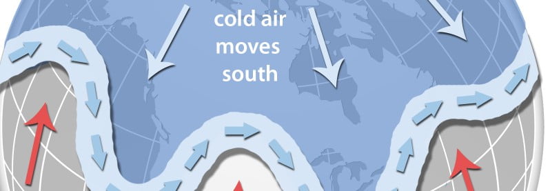
Image credit: NOAA
- Current atmospheric dynamics, including the east phase of the Quasi-Biennial Oscillation (QBO) and the ongoing El Niño, are expected to increase the likelihood of colder winter conditions across parts of the US, Canada, and Europe, according to recent climate model projections. Forecasts also suggest a higher probability of above-average snowfall across the eastern US and parts of Europe.
With the current atmospheric dynamics, including the east phase of the Quasi-Biennial Oscillation (QBO) and the El Niño phase, recent climate model projections suggest an increased likelihood of colder winters in the US, Canada, and Europe. Additionally, forecasts indicate a higher probability of above-average snowfall across the eastern US and Europe.
The term “Polar Vortex” has varying definitions. However, in the context of our winter weather, its importance lies in its strength, as it determines the weather conditions we experience at the surface.
Come autumn, the polar regions start to cool down due to the diminishing angle of the sun, receiving minimal solar energy. In contrast, regions further south continue to receive ample sunlight. This stark temperature difference between the poles and subtropical areas results in the formation of a low-pressure circulation known as the Polar Vortex. This circulation spans from the Earth’s surface to the upper reaches of the atmosphere.
A strong Polar Vortex implies a robust polar circulation, which typically contains the colder air in the polar regions, resulting in milder conditions across places like the US and Europe. A weak Polar Vortex means the colder Arctic air is not confined and can flow into regions like the US and Europe, which can lead to cooler conditions.
Current developments in the stratosphere
The North Pole has already begun its cooling process, which traditionally initiates in August and intensifies in the ensuing months. The Polar Vortex is expected to be at its peak strength during November and December. Current forecasts for September highlight a rapidly developing and expanding Polar Vortex, which, with increasing strength, can have a more pronounced influence on our surface weather.
Analysis from the ECMWF seasonal forecast indicates the Quasi-Biennial Oscillation (QBO) is currently in its east (negative) phase. This suggests a potential for a weaker jet stream, increased frequency of sudden stratospheric warming events, and colder winters across the United States, Canada, and Europe.
Potential effects and implications
During an easterly QBO, the Polar Vortex and stratospheric winter circulation tend to be weaker, leading to an increased likelihood of Sudden Stratospheric Warming (SSW) events. Such events can disrupt the Polar Vortex, resulting in weather impacts across the Northern Hemisphere. These include disruptions in the jet stream and a release of colder Arctic air into Europe and the US.
Moreover, with the onset of the El Niño phase of ENSO, a warm ocean anomaly in the tropical Pacific Ocean, forecasters note an elevated chance of a Polar Vortex collapse in the early winter months. This potential collapse, often observed in December and January, could lead to significant weather changes in January 2024.
According to NOAA’s Climate Prediction Center, El Niño is anticipated to continue through the Northern Hemisphere winter, with greater than 95% chance through December 2023 -February 2024.
Meteorologists from Severe Weather Europe caution that while it’s premature to predict SSW events conclusively, the emerging trends and signals hint at a pattern that warrants close monitoring.
As always, preparedness and continuous monitoring remain key.
References:
1 A Polar Vortex is starting to form in the Stratosphere over the North Pole and will impact the Weather as we head closer to Winter 2023/2024 – Severe Weather Europe – September 11, 2023
The Watchers team and our contributors bring the latest on extreme weather, earthquakes, volcanic eruptions, space weather, and all things science. We're all about making sense of the natural world and keeping you informed on what’s happening. Got a tip or a question? Hit us up using the form at newstips!
Farmers Almanac also shows higher precipitation, colder temps and snow for some areas of U.S. this year, but less precipitation and snow in others. Some areas are expected to have colder or milder temperatures than normal, and other areas warmer than normal. This is to be expected with a gradual ‘magnetic pole shift’, all the topsy-turvy weather patterns -the real reason for climate changing / shifting, not man made. Some areas are able to grow plants they were not able to 25 years ago, but now are, other areas that used to grow the same plants easily, aren’t able to as easy as before. Areas such as Australia will experience higher precipitation, and moss and fern will grow there. The semi-tropical areas will become more tropical.