
Tropical Storm “Talim” heading toward southern China, landfall expected in Guangdong
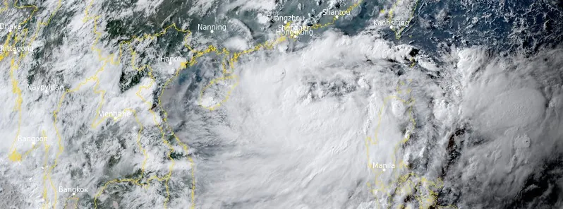
Featured image: Tropical Storm "Talim" at 09:10 UTC on July 16, 2023. Credit: JMA/Himawari-9, RAMMB/CIRA, The Watchers
Tropical Storm “Talim” formed in the East China Sea on July 14, 2023, as the 4th named storm of the 2023 Pacific Ocean typhoon season. The storm is heading toward southern China, with landfall expected in Guangdong Province around 18:00 UTC on July 17.
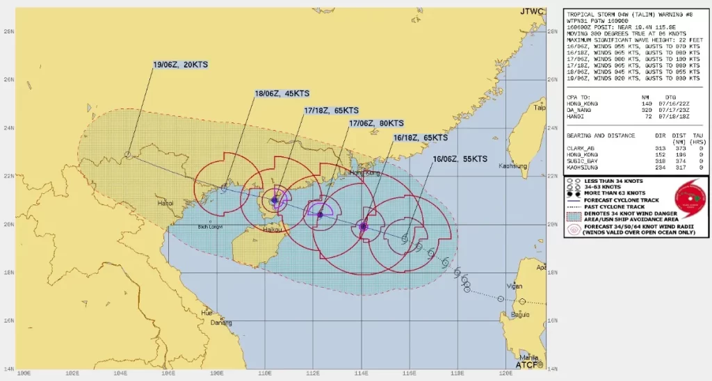
As of 09:00 UTC July 16, the center of Severe Tropical Storm “Talim” was located about 365 km (225 miles) south-southeast of Hong Kong. Its maximum 10-minute sustained winds were at 95 km/h (60 mph), with gusts up to 130 km/h (80 mph), while maximum 1-minute sustained winds were at 100 km/h (65 mph). The minimum central barometric pressure was 980 hPa, and the system was moving west-northwest at 13 km/h (8.1 mph).
Before reaching tropical storm strength, Talim — known as Dodong in the Philippines — made landfall in Dinapigue, Isabela, Philippines, and continued to track westward close to the northern edge of mainland Luzon, crossing through Cagayan and Ilocos Norte.
The winds from Talim enhanced the East Asian monsoon over the Philippines, bringing heavy rainfall and gusty conditions over the country as it neared Luzon. This caused classes to be suspended in three cities and in Cagayan, and three domestic flights to be canceled. The rainfall from the storm also helped raise the water level significantly in Angat Dam, the main water source for areas in Metro Manila, but only slightly in more northern Magat Dam in Isabela. This was beneficial as both dams had neared critical levels as rainfall decreased from the onset of El Niño conditions.
It emerged off the coast of Ilocos Norte at around 09:00 UTC on July 14 and around 15:00 UTC, the JTWC began issuing advisories for the now tropical depression, designated as 04W.
With the system now back in warm seas and moving further westward away from land, it found itself in a favorable environment and began consolidating further. The system intensified into a tropical storm just prior to exiting the Philippine Area of Responsibility (PAR) and was named Talim by the Japan Meteorological Agency (JMA).
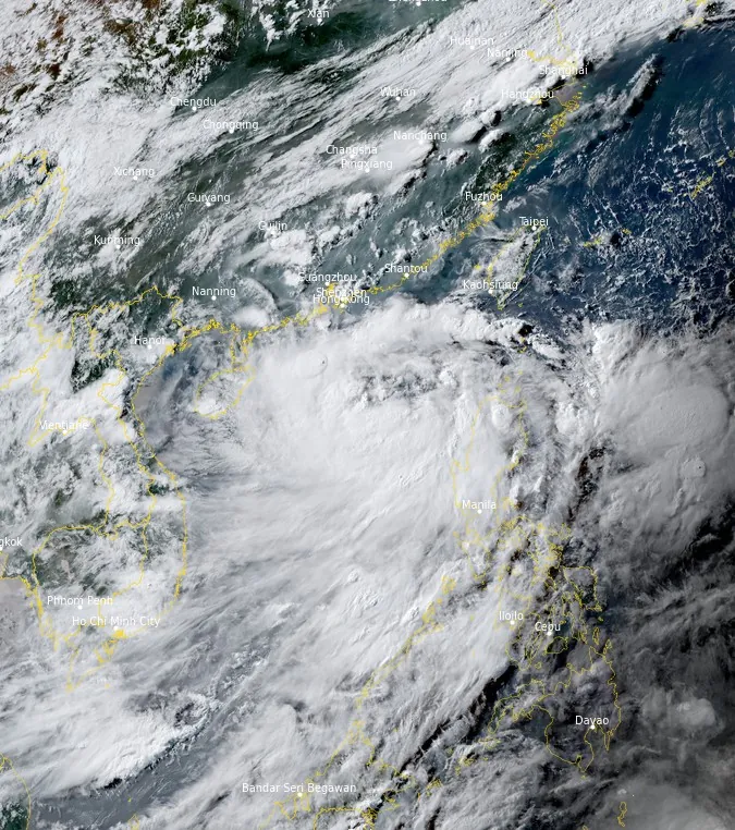
Tropical Storm “Talim” is expected to bring strong winds and heavy rain to Hong Kong in the early hours of Monday morning (LT), July 17. The Hong Kong Observatory (HKO) is considering raising the typhoon warning signal to No. 8, and the public is advised to take precautions.
A woman was injured after a 20 m (65 feet) high tree fell on her at South Bay Beach, and there have been reports of other downed trees and power outages.
The winds from Talim are expected to reach up to 100 km/h (62 mph) in Hong Kong, and the rain is expected to be heavy. The storm is expected to bring high tides and rough seas, and the public is advised to stay away from the shoreline. According to HKO, the storm will likely pass over Hong Kong by Monday afternoon, July 17.
The public is advised to stay informed about the latest weather updates and to take precautions to stay safe during the storm. These precautions include:
- Staying indoors if possible.
- If you must go outside, be aware of your surroundings and take precautions to avoid being injured by falling debris.
- Secure loose objects around your home or workplace.
- Stay away from the shoreline and do not engage in water sports.
- Listen to the radio or television for the latest weather updates.
Landfall is expected over the northern Leizhou Peninsula in far southwestern Guangdong Province around 18:00 UTC on July 17 (early July 18 local time), with maximum sustained winds of 120 km/h (75 mph).
In response to the approaching typhoon, the China Meteorological Administration issued a blue typhoon warning, which is the lowest on a four-tier scale, late on July 15. This warning includes predictions of strong winds over the southern coastal waters and moderate to heavy rainfall in some regions of southern China on July 15 and 16. The most intense rainfall is anticipated over the Leizhou Peninsula, with possible accumulations between 50 and 80 mm (2 – 3 inches).
As of July 15, Vietnam’s National Centre for Hydro-Meteorological Forecasting has yet to release any alerts for land areas. However, the center did caution about potent winds and large waves in northeastern seas and along the northeastern coastline.
Consistent heavy rainfall could lead to flooding in regions with low elevation and in areas with drainage systems prone to failure. Should weather conditions deteriorate, there could be localized evacuations, flash flooding, and potential landslides.
The anticipated weather conditions may also result in local disruptions to businesses, transportation, and utilities, potentially rendering some bridges or roads impassable. Regional airports might experience flight delays or cancellations, and ports may need to temporarily cease operations.
References:
1 Tropical Storm 04W (Talim) – JTWC Warning #08 Issued at 09:00 UTC on July 16, 2023
2 Tropical Storm Talim to be closest to Hong Kong on Monday morning, as city weighs raising typhoon warning signal to T8 – SCMP – July 16, 2023
3 South China Sea: Tropical Storm Talim tracking northwestward in the eastern South China Sea late July 15 /update 1 – Garda – July 15, 2023
I'm a dedicated researcher, journalist, and editor at The Watchers. With over 20 years of experience in the media industry, I specialize in hard science news, focusing on extreme weather, seismic and volcanic activity, space weather, and astronomy, including near-Earth objects and planetary defense strategies. You can reach me at teo /at/ watchers.news.
One wonders if the state of engineering in the Tree Gorges region is improved since they lost so many children in China with an earthquake some time ago?