
Extratropical cyclone wreaks havoc in southern Brazil, drops two months’ worth of rain in one day
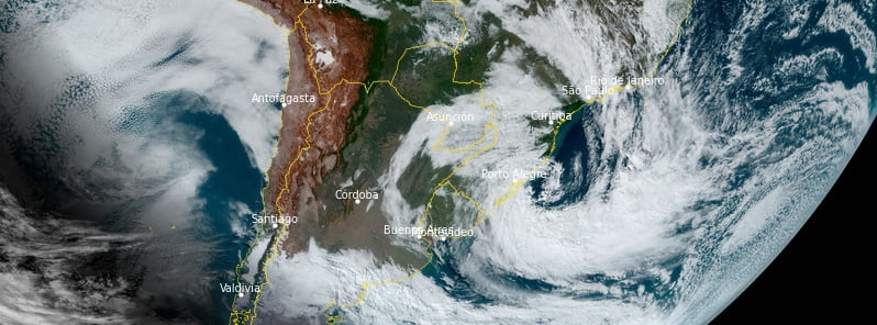
Featured image: Extratropical cyclone off the coast of southern Brazil. Credit: NOAA/GOES-East, RAMMB/CIRA, The Watchers. Acquired at 13:30 UTC on June 16, 2023
An extratropical cyclone, forming off the coast of southern Brazil on Thursday, June 15, 2023, produced excessive rainfall and strong wind gusts, wreaking havoc in Santa Catarina and Rio Grande do Sul. The event is still in progress. There are reports of dead and missing and over 1 million people without power.
An extratropical cyclone that formed overnight near southern Brazil’s coast has triggered severe rainfall and strong wind gusts across Rio Grande do Sul and Santa Catarina. The region witnessed significant rainfall from late Thursday afternoon, followed by powerful gusts between Thursday night and Friday morning.
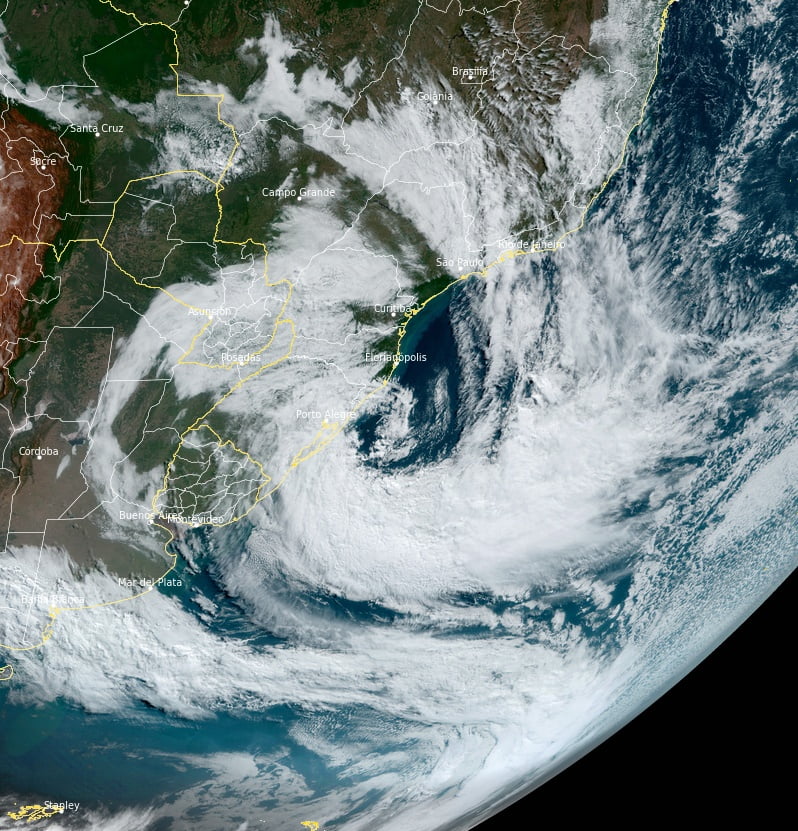
The full extent of the cyclone’s impact is currently under evaluation. However, preliminary observations indicate a very bad situation in Serra, North Coast, and parts of greater Porto Alegre, in line with earlier mathematical model projections.
“The situation is chaotic. There are dead and missing, but as we are still in the middle of the event no number is reliable and can increase soon,” Jorge Furtado told The Watchers.
Rainfall has been exceptional across many regions, reaching volumes typically expected over one to two months in just a single day, Met Sul reported.
This sudden deluge partly explains the widespread damage and rapid flooding in the northeast part of the state. The highest 24-hour accumulation until 03:00 LT on Friday was 262 mm (10.31 inches) in Maquiné, followed by 189 mm (74.4 inches) in Bom Principle and 188 mm (7.40 inches) in Gravataí.
In Porto Alegre, the Cristal neighborhood saw the highest accumulation in 24 hours with 105 mm (4.13 inches), nearly approaching the full-month average of 130.4 mm (5.13 inches) for June.
Concurrently, the cyclone generated moderate to strong winds, with the most significant gust recorded at 102 km/h (63 mph) in Tramandaí on Thursday night.
The extreme weather resulted in landslides, flooding, downed trees, and blocked roads across several points in the Paranhana Valley and North Coast. The current scenario remains risky, with further rain and wind expected throughout Friday. Given the water-saturated soil, there is a heightened risk of landslides on mountainous stretches and slopes.
More than 1 million people are reportedly without electricity.
Additionally, with the heavy rainfall expected to flow through rivers sourced in northeast Rio Grande do Sul, rising river levels and potential flooding are significant concerns. Close monitoring of rivers and streams in Serra and Litoral Norte regions is critical over the next 48 to 72 hours.
Although the cyclone is predicted to move away over the next few hours, it continues to influence eastern Rio Grande do Sul’s weather. Despite this, conditions are expected to improve in the western half of the state, with dry, cold air moving in as the cyclone moves away. However, the coast, particularly the northern coast of Rio Grande do Sul and southern coast of Santa Catarina, still remains on alert for strong winds.
Looking ahead, dry and cold air will dominate the state’s weather over the weekend, with anticipated sunshine and colder mornings. Despite a potentially cloudy start on Saturday, particularly in the east, the weather is expected to settle down. Sunday is forecasted to be sunny with a cold start in most regions.
References:
1 Ciclone provocou aguaceiro com vento e destruição – MetSul – June 16, 2023
The Watchers team and our contributors bring the latest on extreme weather, earthquakes, volcanic eruptions, space weather, and all things science. We're all about making sense of the natural world and keeping you informed on what’s happening. Got a tip or a question? Hit us up using the form at newstips!
Commenting rules and guidelines
We value the thoughts and opinions of our readers and welcome healthy discussions on our website. In order to maintain a respectful and positive community, we ask that all commenters follow these rules.