
More than 600 aftershocks following M5.6 earthquake beneath Lake Taupō, New Zeland
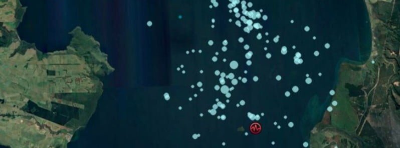
Image credit: Taupō District Council
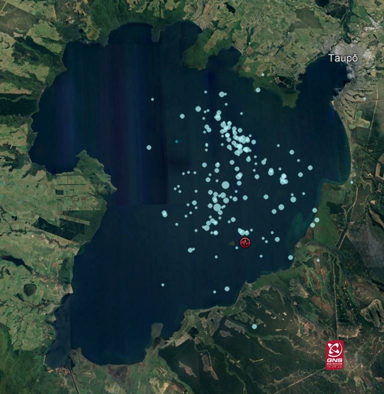
More than 600 aftershocks have been recorded following the M5.6 earthquake beneath Lake Taupō, New Zealand on November 30, 2022 — one of the largest recorded in Lake Taupō region. No further unusual activity has been observed and the minor volcanic unrest at Taupō volcano continues. The Volcanic Alert Level remains at 1.
- Land movements detected from the GNSS network amount up to 250 mm (9.8 inches) as a consequence of the earthquake
- Meanwhile, field teams have been measuring lakeside slumping and inundation distances of the small tsunami, along the lakeshore
Earthquake activity associated with Taupō volcano unrest continues since May 2022, GeoNet’s Duty Volcanologist Geoff Kilgour noted on December 7.1
“The M5.6 earthquake on November 30 was one of the largest recorded in Lake Taupō. Following that earthquake, there have been more than 600 aftershocks located by GeoNet. The number of aftershocks is typical following an earthquake of this size.
“Ground movement associated with the earthquake has been measured by our sensitive GNSS positioning instruments in and around Lake Taupō. The instrument at Horomatangi has shown 250 mm (9.8 inches) of horizontal movement (towards the south-east), which is the largest ever recorded ground movement at this location. GNSS stations onshore are recording a much smaller movement (~10 to 20 mm / 0.4 – 0.8 inches) associated with the earthquake. Further analysis of this data set is underway.”
Experts are also assessing the earthquake-related tsunami in the lake that occurred because of the M5.6 earthquake. This caused run-up along the lakeshore at several locations, mostly focussed on the northern end of Lake Taupō.
Read more:
“Our field teams have been using drone footage and surveying techniques to measure localized lake shore slumping and tsunami inundation… The position of pumice strandlines at Wharewaka Point appears to show the largest tsunami inundation, measured at ~40 m (131 feet) inland. Wave action is likely the result of at least one tsunami, however, we are still assessing their causes. More analysis of existing data, coupled with additional field survey results, should enable our experts to develop models of what happened.”
While the magnitude and rate of aftershocks started to decline, they are expected to continue for several weeks. Within the next 7 days, there is a 7% chance of one or more earthquakes of M5 or larger. Within the next 30 days, there is a 16% chance of one or more earthquakes of M5 or larger.
The recorded ground deformation and earthquake activity is likely caused by magma and hydrothermal fluids deep beneath Taupō volcano, Kilgour said.
This period of unrest is one of at least 17 previous episodes at Taupō over the past 150 years. None of those unrest periods resulted in an eruption and the activity observed last week appears no different.
Previous unrest at Taupō has continued for months to years. Based on this history, the current unrest period could continue for many weeks to months at varying rates or intensities.
Moderate to large earthquake activity can cause landslides into the lake, slumping of steep underwater slopes, and displacement of the lake floor due to faulting, all of which can generate unusual wave activity. Tsunami or unusual waves in lakes are also known as seiches.
Kilgour urged people who feel the strong ground shaking, hear a loud boom, or notice unusual lake conditions, to move away from the lakeshore.
“We understand that the earthquakes and tsunami recorded over the last week can be unsettling for some, but the activity we have seen is within the bounds expected during a period of minor unrest at Taupō. We continue to closely monitor the volcano, and when we have more information, we will share this.”
Geological summary
Taupo, the most active rhyolitic volcano of the Taupo volcanic zone, is a large, roughly 35 km (21 miles) wide caldera with poorly defined margins. It is a type example of an “inverse volcano” that slopes inward toward the most recent vent location.
The caldera, now filled by Lake Taupo, largely formed as a result of the voluminous eruption of the Oruanui Tephra about 22 600 years before the present (BP).
This was the largest known eruption at Taupo, producing about 1 170 km3 (281 mi3) of tephra. This eruption was preceded during the late Pleistocene by the eruption of a large number of rhyolitic lava domes north of Lake Taupo.
Large explosive eruptions have occurred frequently during the Holocene from many vents within Lake Taupo and near its margins.
The most recent major eruption took place about 1 800 years BP from at least three vents along a NE-SW-trending fissure centered on the Horomotangi Reefs. This extremely violent eruption was New Zealand’s largest during the Holocene and produced the thin but widespread phreatoplinian Taupo Ignimbrite, which covered 20 000 km2 (7 722 mi2) of North Island.2
References:
1 No further unusual activity since the M5.6 earthquake beneath Lake Taupō. Volcanic Alert Level remains at Level 1 – GeoNet – December 7, 2022
2 Taupō – Geological summary – GVP
I'm a dedicated researcher, journalist, and editor at The Watchers. With over 20 years of experience in the media industry, I specialize in hard science news, focusing on extreme weather, seismic and volcanic activity, space weather, and astronomy, including near-Earth objects and planetary defense strategies. You can reach me at teo /at/ watchers.news.
Commenting rules and guidelines
We value the thoughts and opinions of our readers and welcome healthy discussions on our website. In order to maintain a respectful and positive community, we ask that all commenters follow these rules.