
Uplift at Askja volcano up to 35 cm (13 inches) since August 2021, Iceland
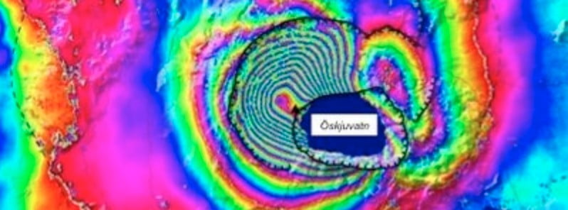
Image credit: Copernicus EU/Sentinel-1, IMO
Scientists from the Institute of Geosciences, the Icelandic Met Office (IMO) and representatives of Iceland’s civil protection met on July 25, 2022, to discuss land changes and earthquakes at Askja volcano observed over the past few months.
A clearer picture has now been obtained of the landmass in the area through the processing and interpretation of satellite images after the snow has melted in the area.
An uplift of 35 cm (13.7 inches) centered west of Lake Askja has been measured since August 2021, IMO said.1
While the rate of the uplift is extraordinary compared to similar volcanoes in the world, seismic activity has not been high along with this, possibly because decades before the current uplift period began, there was persistent land subsidence in Askja. Also, part of the deformation can occur on caldera cracks that can move partially without seismic activity.
Model calculations indicate that the depth of the magma accumulation is about 2 km (1.2 miles) and that the magma spreads horizontally in the earth’s crust in the center of the volcano.
The possible future scenarios remain the same as previously reported.
If the magma buildup persists, the rising process may continue in a similar fashion for some time. Increased seismic activity is expected to be a clear prelude to further underground magma movements or eruptions.
The most likely scenario in the event of an eruption is a fissure eruption in the vicinity of the caldera.
Measurements of volcanoes with mature calderas, as in the case of Askja, show that there can be large crustal movements without an eruption, even so that movements amount to more than 1 m (3.3 feet) before an eruption occurs.
However, it cannot be ruled out that in the case of Askja, the notice will be short, even a few hours.
Iceland’s Civil Protection Department uncertainty level is in effect in Askja and the Norwegian Meteorological Agency continues to monitor the area closely in cooperation with the Civil Defense, the police and Vatnajökull National Park.
Geological summary
Askja is a large basaltic central volcano that forms the Dyngjufjöll massif. It is truncated by three overlapping calderas, the largest of which is 8 km (5 miles) wide and may have been produced primarily from subglacial ring-fracture eruptions rather than by subsidence.
A major rhyolitic explosive eruption from Dyngjufjöll about 10 000 years ago was in part associated with the formation of Askja caldera.
Many postglacial eruptions also occurred along the ring-fracture. A major explosive eruption on the SE caldera margin in 1875 was one of Iceland’s largest during historical time. It resulted in the formation of a smaller 4.5-km-wide (2.8 miles) caldera, now filled by Öskjuvatn lake, that truncates the rim of the larger central caldera.
The 100-km-long (62 miles) Askja fissure swarm, which includes the Sveinagja graben, is also related to the Askja volcanic system, as are several small shield volcanoes such as Kollatadyngja. Twentieth-century eruptions have produced lava flows from vents located mostly near Öskjuvatn lake.
The renowned flat-topped Icelandic table mountain Herdubreid, located NE of Askja volcano, was active until the late Pleistocene.2
References:
1 Fundur um þróun mála við Öskju – IMO – July 26, 2022
2 Askja – Geological summary – GVP
I'm a dedicated researcher, journalist, and editor at The Watchers. With over 20 years of experience in the media industry, I specialize in hard science news, focusing on extreme weather, seismic and volcanic activity, space weather, and astronomy, including near-Earth objects and planetary defense strategies. You can reach me at teo /at/ watchers.news.
Commenting rules and guidelines
We value the thoughts and opinions of our readers and welcome healthy discussions on our website. In order to maintain a respectful and positive community, we ask that all commenters follow these rules.