
Severe damage after major tornado hits Andover, Kansas
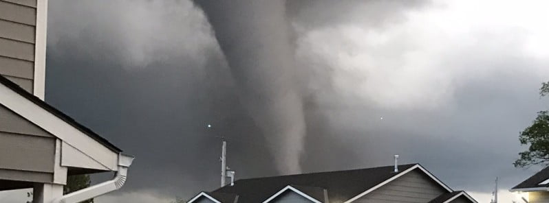
Image credit: Kristine/Twitter
A major tornado developed over eastern Wichita, Kansas on April 29, 2022, and entered the city of Andover just after 20:00 LT, damaging or destroying up to 100 homes. At least 8 people have been injured, one seriously.
A spokesperson for the Kansas Division of Emergency Management said the extent of the damage is not completely available, but social media images show damaged buildings and flipped cars.
According to the Greater Wichita YMCA, multiple cars were pushed up against the Andover YMCA where significant damage has been reported. Luckily, no injuries occurred as employees and members took shelter.
Andover fire chief Chad Russell said emergency workers had done the first round of assessments for injuries and were beginning to check properties in damaged areas more methodically.1
There were 966 buildings in the tornado path, Russel said.
Some neighborhoods were damaged enough that houses were completely blown down, he said.
According to Wichita Mayor Brandon Whipple, roughly 50 to 100 structures were damaged.
“Multiple agencies are assisting us right now with tonight’s tornado. If you need a place to take refuge, respond to ST. Vincent De Paul, 123 N. Andover Rd. Roads are blocked on most major intersections due to down power lines and large debris,” Andover Police Department said.
Just 90 minutes after the tornado, Andover was hit by golf ball-sized hail.
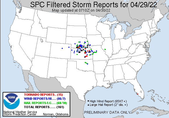
NWS Storm Prediction Center received 15 tornado reports on April 29, 11 from Kansas, 3 from Nebraska, and 1 from Florida.
Severe thunderstorms and localized flash flooding will continue through portions of the Central Plains and extend into parts of the Middle Mississippi and Lower Ohio Valleys on Saturday, April 30, NWS said.
On Saturday, April 30, a relatively strong surface low will move into the upper Mississippi Valley as an associated occluded/cold front sweeps eastward across the Midwest into the lower Ohio Valley, NWS forecaster Otto said.2
Severe thunderstorms and localized flash flooding will be possible with thunderstorms that develop ahead of the cold front, with better chances for severe storms from the middle Mississippi Valley toward southern portions of Lake Michigan.
The cold front will stall and eventually retreat across the southern Plains on Sunday where the potential for strong to severe thunderstorms will exist across portions of western Texas.
Update
According to the preliminary information provided by NWS, this was an EF-3 tornado with estimated peak winds of 265 km/h (165 mph). It touched down at 20:10 LT and traveled for 20.5 km (12.75 miles) until it dissipated at 20:31. The maximum width was 402 m (440 yards).3
3 injuries were directly related to the tornado – 2 in Sedgwick County and 1 in Buttler.
References:
1 ‘Very bad damage’ but few injuries seen after tornado tears through SE Wichita, Andover – The Wichita Eagle – April 30, 2022
2 Short Range Forecast Discussion – NWS Weather Prediction Center College Park MD – 359 PM EDT Fri April 29, 2022
3 Extreme tornado footage captured by drone over Andover, Kansas – The Watchers – May 2, 2022
I'm a dedicated researcher, journalist, and editor at The Watchers. With over 20 years of experience in the media industry, I specialize in hard science news, focusing on extreme weather, seismic and volcanic activity, space weather, and astronomy, including near-Earth objects and planetary defense strategies. You can reach me at teo /at/ watchers.news.
Commenting rules and guidelines
We value the thoughts and opinions of our readers and welcome healthy discussions on our website. In order to maintain a respectful and positive community, we ask that all commenters follow these rules.