
Saharan dust storm transforms skies and landscapes in parts of Europe
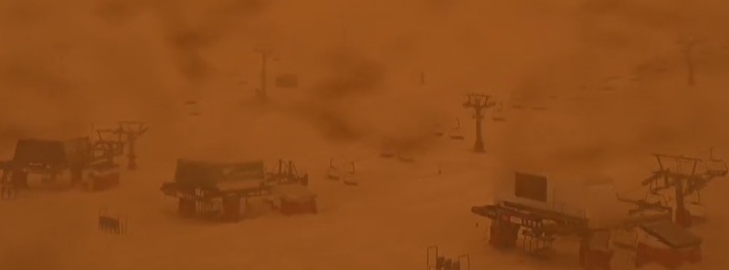
Image credit: Sierra Nevada SKI
A Saharan dust storm has transformed skies and landscapes in parts of Europe on Tuesday, March 15, 2022.
The dust plumes have already reached northern Europe and are now crossing the Atlantic Ocean toward South America.
A #SaharanDust storm has transformed skies and landscapes in parts of Europe today, affecting air quality.
This is the view of the Jura mountains in Switzerland from @meteosuisse.
Forecasts from @Dust_Barcelona https://t.co/k68I3MwGhc pic.twitter.com/Ntv157kNNk— World Meteorological Organization (@WMO) March 15, 2022
Believe it or not, this is Sierra Nevada SKI resort in southern #Spain, transformed by a thick plume of #SaharanDust.
From the station’s webcam and via @CLIMATEwBORDERS https://t.co/gHF85ut2Gx pic.twitter.com/Xg9j2vTk73— World Meteorological Organization (@WMO) March 15, 2022
Impressive extent of #SaharanDust across the Atlantic to South America & across W Europe and Mediterranean in the @CopernicusECMWF Atmosphere Monitoring Service @ECMWF 5-day aerosol optical depth 14 March 00 UTC forecast. Data available from https://t.co/W84Bwszpqr pic.twitter.com/CfdJ30QpC4
— Mark Parrington (@m_parrington) March 14, 2022

Image credit: NOAA/GOES-16, Zoom.Earth, TW. Acquired at 17:00 UTC on March 15, 2022
I'm a dedicated researcher, journalist, and editor at The Watchers. With over 20 years of experience in the media industry, I specialize in hard science news, focusing on extreme weather, seismic and volcanic activity, space weather, and astronomy, including near-Earth objects and planetary defense strategies. You can reach me at teo /at/ watchers.news.
I found this site a few weeks ago. Just for highlights. Then realized the extent of your reports, showing charts that show airflow and how the dust moved N into Europe. I was a certified WX observer and Pilot weather briefer for my working life and love to be able to get this type of info.