
Ice sheet at Grímsvötn subsided almost 10 m (33 feet), Iceland
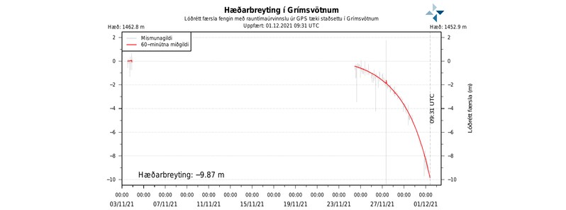
Image credit: IMO
The GPS meter in Grímsvötn shows that the ice cap continues to descend and it has sunk almost 9.87 m (32.4 feet) since it was measured highest on November 24, 2021, the Icelandic Meteorological Office (IMO) reports.
Running water has now appeared in Gígjukvísl and the water level there has risen gradually yesterday and last night.1
IMO hydrologists are on their way to the scene and they will monitor the development of the run and measure the flow in the river.
It can be expected that the water level and flow will continue to increase in Gígjukvísl in the next few days.
Image credit: IMO
Glaciologists at the Institute of Earth Sciences at the University of Iceland have published a forecast model that assumes that the maximum flow in this event will be reached around next weekend or the beginning of next week, December 6.
Flow from Grímsvötn has grown more slowly in this run than in Grímsvatnahlaup in 2010, and based on the latest data, the maximum flow in Gígjukvísl is expected to be around 4 000 m3/s (141 000 ft3/s).
There is no chance that running water will enter the old channel of Skeiðará, IMO said.
Measurements carried out by the University's Institute of Earth Sciences on November 29 indicate that about 0.1 km3 (0.02 mi3) of water has already left the lakes, which is about 10% of the water that was in Grímsvötn before the iceberg began to sink.
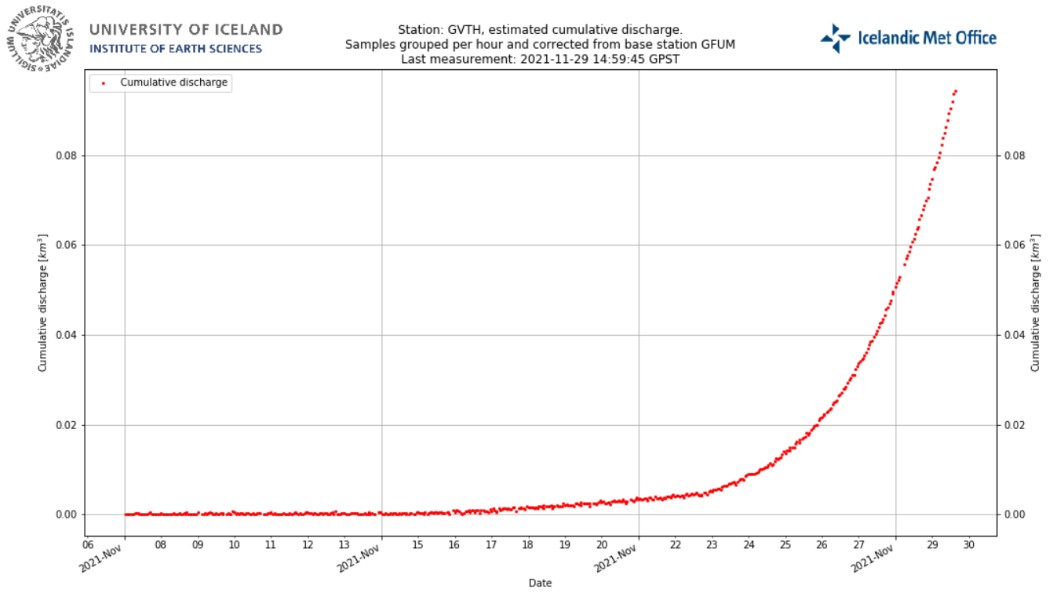
Image credit: IMO
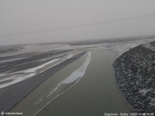
Image credit: IMO
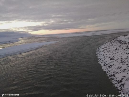
Image credit: IMO
There are past examples of Grímsvötn eruptions starting following a flood.2
The loss of the water from Grímsvötn lake reduces the pressure on top of the volcano and this can allow an eruption to begin.
This happened in 2004, and before that in 1934 and in 1922, IMO said.
In 2004 the eruption started three days after the first observations were made of flood onset. There were a series of earthquakes in the days preceding the eruption. No such earthquakes have been measured at this point in time.
According to Benedikt Gunnar Ófeigsson, deformation scientist at the IMO, there is every indication that the Grímsvötn volcano is ready to erupt.3
The last eruption of this volcano took place in 2011 — it was a large and powerful VEI 4 eruption. The average eruption frequency during the last 1 100 years is 1 eruption per 10 years.
Geological summary
Grímsvötn, Iceland's most frequently active volcano in historical time, lies largely beneath the vast Vatnajökull icecap. The caldera lake is covered by a 200 m (650 feet) ice shelf, and only the southern rim of the 6 x 8 km (3.7 x 5 miles) caldera is exposed.
The geothermal area in the caldera causes frequent jökulhlaups (glacier outburst floods) when melting raises the water level high enough to lift its ice dam.
Long NE-SW-trending fissure systems extend from the central volcano. The most prominent of these is the noted Laki (Skaftar) fissure, which extends to the SW and produced the world's largest known historical lava flow during an eruption in 1783.
The 15 km3 (3.6 mi3) basaltic Laki lavas erupted over a 7-month period from a 27 km (16.7 miles) long fissure system. Extensive crop damage and livestock losses caused a severe famine that resulted in the loss of one-fifth of the population of Iceland.4
References:
1 Icesheet in Grímsvötn subsiding – IMO
2 Ice sheet in Grímsvötn subsiding, could lead to an eruption, Iceland – The Watchers
3 Grímsvötn volcano ready to erupt, Iceland – The Watchers
4 Grímsvötn – Geological summary – GVP
I'm a dedicated researcher, journalist, and editor at The Watchers. With over 20 years of experience in the media industry, I specialize in hard science news, focusing on extreme weather, seismic and volcanic activity, space weather, and astronomy, including near-Earth objects and planetary defense strategies. You can reach me at teo /at/ watchers.news.
Commenting rules and guidelines
We value the thoughts and opinions of our readers and welcome healthy discussions on our website. In order to maintain a respectful and positive community, we ask that all commenters follow these rules.