
Heavy rain, snow, and high winds in the West, severe thunderstorms shift to the East, U.S.

Image credit: NOAA/GOES-West, RAMMB/CIRA, TW. Acquired at 22:00 UTC on October 24, 2021
A strong storm off the Pacific Northwest will continue directing a stream of heavy rain, high elevation snow and gusty to high winds over much of central and northern California, the Sierra Nevadas and the Great Basin Monday, October 25, 2021. Thunderstorms associated with isolated wind damage are possible over parts of the southern and central Appalachians into the Carolinas and Middle Atlantic region today.
"Evacuations were ordered, roads were closed and hundreds of thousands of people were without electricity Sunday night as a powerful storm roared across parts of California and the Pacific," Jan Wesner Childs of TWC reports.1
According to PowerOutage.us, 400 000 customers were reported without power across three western states on Sunday — 175 000 in California, 179 000 in Washington, and 28 000 in Oregon. By 08:00 UTC on October 25, the total number dropped to 213 800 — 149 600 in California and 64 200 in Washington.
Heavy rains resulted in flash floods and several landslides, including one in the Dixie Fire burn scar that shut down Highway 70 near Tobin in Plumas County.
Spectacular Geocolor satellite imagery of the spiraling storm off the Washington coast and associated #AtmosphericRiver impacting the West. #IDwx #ORwx #BombCyclone pic.twitter.com/5YrqXvjDqL
— NWS Boise (@NWSBoise) October 24, 2021
Video of landslide as well as other rock slides, debris flows and mudslides along Hwy 70 in Plumas County. #debrisflows #wxtwitter @NWSSacramento #flooding #CaWx pic.twitter.com/txZ623iQix
— WXChasing (Brandon Clement) (@bclemms) October 24, 2021
Landslide on Hwy 70 near Tobin, Ca has the highway shutdown and will likely be for a long duration. #CAwx #wxtwitter #AtmosphericRiver pic.twitter.com/MlBVa19Dyl
— WXChasing (Brandon Clement) (@bclemms) October 24, 2021
This is how the #SierraNevada in #Tahoe looks like after 24h of rain! #storm #rain #flood #flooding #atmosphericriver #AR #weather #extremweather #palisadestahoe @palisadestahoe pic.twitter.com/eGHE5kEUkF
— Malte Humpert (@malte_humpert) October 24, 2021

Image credit: NOAA/GOES-West, RAMMB/CIRA, TW. Acquired at 22:00 UTC on October 24, 2021
Sacramento broke its all-time one-day rainfall record on October 24 with 134.6 mm (5.3 inches). The previous record of 134.1 mm (5.28 inches) was set in 1880.
10.2 mm (4.02 inches) of rain was recorded in downtown San Francisco on the same day, making it the city's wettest October day ever — the previous October rainfall record was 6.2 mm (2.48 inches) set on October 13, 2009. This was also the 4th wettest day ever in San Francisco since records began.
A strong storm just west of the Pacific Northwest Coast will impact the West Coast over the next several days, NWS forecaster Ziegenfelder noted at 20:06 UTC on October 23.2
Strong onshore flow will stream moisture into Northern/Central California, producing heavy rain and snow over parts of California. Therefore, the WPC has issued a High Risk of excessive rainfall over the Sierra Nevada Mountains through Monday morning.
Significant and potentially life-threatening flash flooding flash is expected with the storm, with some areas that normally do not experience flash flooding flooded.
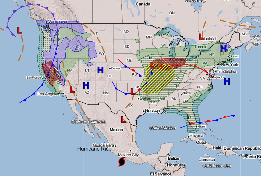
Image credit: NOAA/WPC
Heavy snow is also forecast for the Sierra Nevada Mountains through late Monday afternoon. The excessive rainfall threat lessens to a Slight Risk over parts of the Sierra Nevada Mountains with a Marginal Risk over other parts of the Sierra Nevada Mountains and parts of the Southern California Coast from Monday into Tuesday morning. The excessive rainfall threat for California ends on Tuesday, October 26.
Moreover, rain and highest elevation snow will develop over parts of the Pacific Northwest into the Northern Intermountain Region and continue into Monday. On Monday, after the front passes, the snow levels will lower over the Northwest portion of the country. On Tuesday, rain and higher elevation snow move into the Rockies, with rain developing over parts of the Northern/Central High Plains by Tuesday evening.
The Storm Prediction Center has issued an Enhanced Risk of severe thunderstorms over parts of the Middle/Lower Mississippi and Ohio Valleys through Monday morning.
The hazards associated with these thunderstorms are frequent lightning, severe thunderstorm wind gusts, hail, and a few tornadoes. Furthermore, there is a 10% or greater probability of EF2 – EF5 tornadoes over parts of the region and a 10% or greater probability of wind gust of 120 km/h (75 mph).
Additionally, there is a 10% or greater probability of 5 cm (2 inches) or larger hail over parts of northeastern Missouri through Monday morning.
However, the severe thunderstorm threat is not the only threat over the Midwest. Heavy rain will develop along the front, therefore, the Weather Prediction Center has issued a Moderate Risk of excessive rainfall with the rain and thunderstorms over parts of the Ohio Valley through Monday morning. The associated heavy rain will create numerous areas of flash flooding — many streams may flood, potentially affecting larger rivers.
References:
1 Landslides, Flooding Clobber California – TWC
2 Short Range Forecast Discussion – NWS Weather Prediction Center College Park MD – 406 PM EDT Sun Oct 24 2021
I'm a dedicated researcher, journalist, and editor at The Watchers. With over 20 years of experience in the media industry, I specialize in hard science news, focusing on extreme weather, seismic and volcanic activity, space weather, and astronomy, including near-Earth objects and planetary defense strategies. You can reach me at teo /at/ watchers.news.
Commenting rules and guidelines
We value the thoughts and opinions of our readers and welcome healthy discussions on our website. In order to maintain a respectful and positive community, we ask that all commenters follow these rules.