
Hurricane “Pamela” – Life-threatening storm surge, dangerous winds, and threat of significant flash flooding and mudslides, Mexico
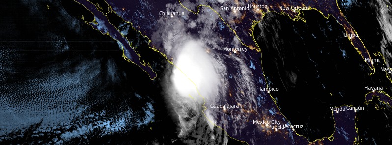
Featured image: Hurricane "Pamela" at 09:00 UTC on October 13, 2021. Credit: NOAA/GOES-West, RAMMB/CIRA, TW
Pamela regained hurricane strength as its center came closer to the coast of Mexico on October 13, 2021. The system is forecast to make landfall on the west-central coast of Mexico this morning (LT) and life-threatening storm surge and dangerous hurricane-force winds are expected within the Hurricane Warning area. Residents in this area should follow any advice given by local officials, NHC said.
- Heavy rains associated with Pamela are expected to continue to move into the Mexican States of Sinaloa and western Durango today. This will pose a threat of significant and life-threatening flash flooding and mudslides.
- Heavy rains associated with the remnants of Pamela are expected across portions of central Texas and southeastern Oklahoma later today or Thursday. This may result in considerable flash and urban flooding impacts.1
As of 09:00 UTC on October 13, a Hurricane Warning is in effect for Bahia Tempehuaya to Escuinapa and a Tropical Storm Warning for North of Bahia Tempehuaya to Altata; South of Escuinapa to Cabo Corrientes; Islas Marias.2
At the time, the center of Hurricane "Pamela" was located about 130 km (80 miles) WSW of Mazatlan, Mexico. The system had maximum sustained winds of 120 km/h (75 mph), minimum central pressure of 987 hPa, and was moving NE at 22 km/h (14 mph).
A faster northeastward motion is expected later today.
On the forecast track, the center of Pamela will make landfall in west-central Mexico within the hurricane warning area later this morning and move inland over western Mexico later today.

Storm surge is expected to produce significant coastal flooding in areas of onshore winds near where the center of Pamela makes landfall in southwestern Mexico. Near the coast, the surge will be accompanied by large and destructive waves.
Hurricane conditions are expected within the Hurricane Warning area in a couple of hours, with tropical storm conditions continuing to spread over portions of the coast.
Through Thursday, October 14, Pamela or its remnant is expected to produce the following rainfall amounts:
Across the Mexican States of Sinaloa, western Durango, and northern Nayarit 100 – 200 mm (4 to 8 inches) with isolated maximum totals of 300 mm (12 inches). This rainfall may trigger significant and life-threatening flash flooding and mudslides.
Across portions of central Texas and southeastern Oklahoma 75 to 150 mm (3 to 6 inches) with isolated maximum totals of 200 mm (8 inches). This may result in considerable flash and urban flooding impacts.
Swells generated by Pamela will continue to affect portions of the southern Baja California peninsula, as well as southwestern and west-central mainland Mexico through today. These swells are likely to cause life-threatening surf and rip current conditions.
References:
1 Hurricane Pamela Discussion Number 13 – NWS National Hurricane Center Miami FL EP162021 – 300 AM MDT Wed Oct 13 2021
2 BULLETIN – Hurricane Pamela Advisory Number 13 – NWS National Hurricane Center Miami FL EP162021 – 300 AM MDT Wed Oct 13 2021
I'm a dedicated researcher, journalist, and editor at The Watchers. With over 20 years of experience in the media industry, I specialize in hard science news, focusing on extreme weather, seismic and volcanic activity, space weather, and astronomy, including near-Earth objects and planetary defense strategies. You can reach me at teo /at/ watchers.news.
good! maybe it will sweep away the illegals trying to get into our country.