
New vents open at Cumbre Vieja volcano, more evacuations ordered – La Palma, Canary Islands
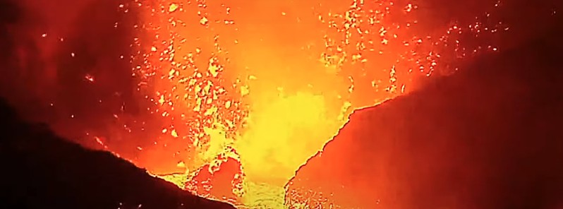
Image credit: TV Canarias
The magnitude of volcanic tremor at Cumbre Vieja, La Palma, Canary Islands increased on September 24, 2021, reaching the highest intensity since the eruption began on September 19.
Two new vents have opened, producing new lava flows, with power Strombolian explosions generating impressive shock waves.
As a result, new evacuations have been ordered for Tajuya and Tacande.
"The fountaining is remarkably stable, although at times briefly interrupted by giant lava bubble explosions that eject glowing lava bombs in all directions to more than 1 000 m (3 280 feet), often showering the whole cone with red-hot lava ejecta," said Dr. Tom Pfeiffer of VolcanoDiscovery.
"Some of these produce cannon-shot loud detonations with visible shock waves that are felt in many kilometers distance."
Captamos la brutal onda expansiva de una de las explosiones más potentes del Volcán de La Palma en su sexto dia #lapalma #noticiaslapalma #terremotoslapalma #volcánlasmanchas #urgencaislapalma #emergencialapalma #lavalapalma #VigilanciaLaPalma pic.twitter.com/4EDgFve7nW
— El Time (@ElTimeLaPalma) September 24, 2021
In explosive volcanic eruptions, shock waves are generated due to the sudden decompression of the system. These waves of compressed air propagate through the atmosphere and can travel for kilometres at speeds faster than that of sound #lapalmaeruption pic.twitter.com/M0L3DGVfy6
— INVOLCAN (@involcan) September 24, 2021
Secuencia de vídeo infrarrojo de la actividad actual y las coladas de lava procedentes de las dos nuevas bocas eruptivas / Infrared vídeo of the current activity and the lava flows coming from the two brand new eruptive vents pic.twitter.com/YBsOJtckOW
— INVOLCAN (@involcan) September 24, 2021
Imágenes tomadas a las 20.30 (hora canaria) de hoy / Video taken today at 8.30 p.m. (Canarian hour) pic.twitter.com/ctiXoRtRWR
— INVOLCAN (@involcan) September 23, 2021
Imágenes de la #erupcionlapalma a las 19.00 (hora canaria) / Video of the #lapalmaeruption at 7.00 p.m. (Canaria hours) pic.twitter.com/qpZPjunlL0
— INVOLCAN (@involcan) September 23, 2021
At least 420 buildings have been destroyed as of September 23.
The lava flow now covers more than 190.7 ha (471.2 acres), representing a change of +10.6 ha (26.2 acres) in 18 hours.
In addition, 15.2 km (9.4 miles) of roads have been destroyed.
Authorities said firefighters were forced to retreat amid intensifying volcanic explosions.
In total, since the beginning of the seismic activity on September 11, a total of 1 451 earthquakes have been located, with 87 of them felt by the population with a maximum intensity III-IV (EMS98), IGN said on September 24.
The deformation of the terrain has remained stable in recent days. Since the beginning of the activity, 22 cm (8.6 inches) of vertical deformation has been recorded in the GNSS station LP03, the station closest to the eruption. The total accumulated deformation using the Sentinel-1 images of the European Space Agency and InSAR methodology is 28 cm (11 inches).
The inclinometer has seen its signal disturbed since the beginning of the eruption.
The eruption has produced a lava flow with several fronts, which after advancing at about 700 m (2 300 feet) per hour during the first days, have been slowing down to less than 10 m (33 feet) per hour.
Since September 23, the volcanic ash column has exceeded 5 000 m (16 400 feet) in height above mean sea level.
Geological summary
The 47-km-long (29 miles) wedge-shaped island of La Palma, the NW-most of the Canary Islands, is composed of two large volcanic centers. The older northern one is cut by the massive steep-walled Caldera Taburiente, one of several massive collapse scarps produced by edifice failure to the SW.
The younger Cumbre Vieja, the southern volcano, is one of the most active in the Canaries.
The elongated volcano dates back to about 125 000 years ago and is oriented N-S. Eruptions during the past 7 000 years have originated from the abundant cinder cones and craters along the axis of Cumbre Vieja, producing fissure-fed lava flows that descend steeply to the sea.
Historical eruptions at La Palma, recorded since the 15th century, have produced mild explosive activity and lava flows that damaged populated areas.
The southern tip of the island is mantled by a broad lava field produced during the 1677-1678 eruption. Lava flows also reached the sea in 1585, 1646, 1712, 1949, and 1971. (GVP)
I'm a dedicated researcher, journalist, and editor at The Watchers. With over 20 years of experience in the media industry, I specialize in hard science news, focusing on extreme weather, seismic and volcanic activity, space weather, and astronomy, including near-Earth objects and planetary defense strategies. You can reach me at teo /at/ watchers.news.
Our prayers
Bring it on. We need some help over here on the East Coast with a huge tsunami.