Tropical Storm “Fred” to make landfall in the western Florida Panhandle, U.S.
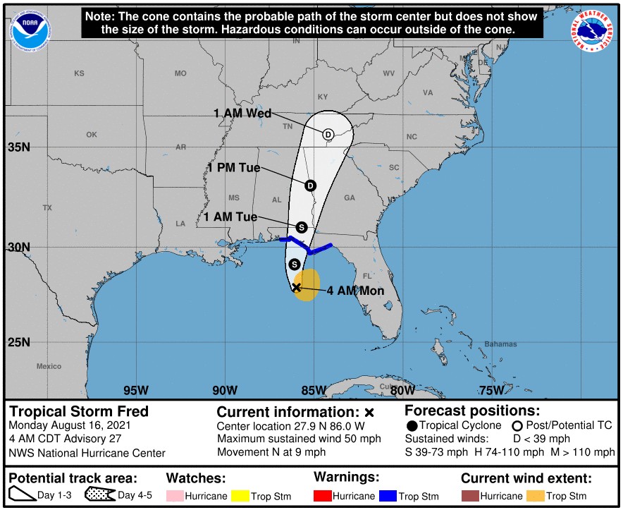
Tropical Storm "Fred" is forecast to make landfall in the western Florida Panhandle in the afternoon on August 16, 2021, bringing heavy rainfall and dangerous storm.
- Heavy rainfall may lead to flash, urban, small stream, and isolated river flooding impacts across the Southeast, NHC warns.
- By the middle of the week, as Fred lifts northward and inland, heavy rainfall and flooding will impact the southern and central Appalachians, the Piedmont of the Southeast, and the Mid-Atlantic.
- Dangerous storm surge inundation is possible along portions of the coast of the Florida Panhandle and the Florida Big Bend region.
A Storm Surge Warning is in effect for the coast of Florida from Indian Pass to Yankeetown. A Tropical Storm Warning for the coast of the Florida Panhandle from Navarre to the Wakulla/ Jefferson County line.
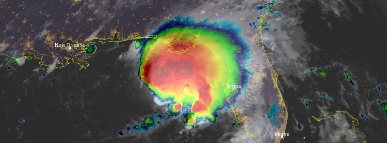
At 09:00 UTC on August 16, the center of Tropical Storm "Fred" was located about 255 km (160 miles) S of Panama City and 220 km (140 miles) SSW of Apalachicola, Florida.
Its maximum sustained winds were 85 km/h (50 mph) and minimum central pressure 1 002.
Fred is moving toward the north at 15 km/h (9 mph) and this general motion with a slight increase in forward speed is expected through today.
On the forecast track, the center of Fred should move across the northeastern Gulf of Mexico today, and make landfall in the western Florida Panhandle this afternoon or early evening (LT), according to the NHC.
While some strengthening is forecast before landfall, Fred is expected to quickly weaken afterward.
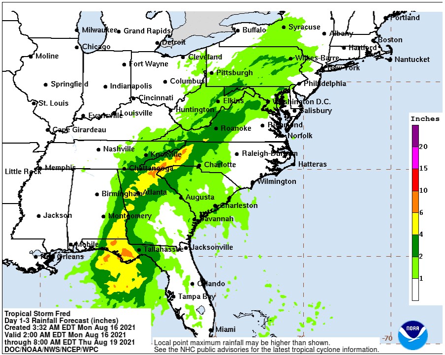
Through the end of the day, Southern and Central Florida are expected to receive 25 to 50 mm (1 to 2 inches) of additional rain with isolated maximum storm totals of 125 mm (5 inches).
Through Tuesday, August 17, the Florida Big Bend and Panhandle can expect 100 to 200 mm (4 to 8 inches) of rain with isolated maximum storm totals of 305 mm (12 inches). Southeast Alabama through western and northern Georgia, and the western Carolinas can expect 100 to 180 mm (4 to 7 inches) of rain with isolated maximum storm totals of 250 mm (10 inches) are expected.
Through Wednesday, August 18, portions of the Mid-Atlantic states could receive 50 to 100 mm (2 to 4 inches) of rain with isolated maximum storm totals of 150 mm (6 inches) as Fred interacts with a nearby front.
Heavy rainfall across portions of the Southeast and Mid-Atlantic States could lead to flash, urban, small stream and isolated river flooding impacts, NHC said.
The combination of a dangerous storm surge and the tide will cause normally dry areas near the coast to be flooded by rising waters moving inland from the shoreline.
The water could reach the following heights above ground somewhere in the indicated areas if the peak surge occurs at the time of high tide:
- Indian Pass, FL to Steinhatchee River, FL 0.9 to 1.5 m (3 – 5 feet)
- Steinhatchee River, FL to Yankeetown, FL 0.6 to 1.2 m (2 – 4 feet)
- AL/FL border to Indian Pass including Pensacola Bay, Choctawhatchee Bay and Saint Andrew Bay 0.3 to 0.9 m (1 – 3 feet)
- Yankeetown, FL to Aripeka, FL 0.3 to 0.9 m (1 – 3 feet)
The deepest water will occur along the immediate coast near and to the east of the landfall location, where the surge will be accompanied by large waves. Surge-related flooding depends on the relative timing of the surge and the tidal cycle, and can vary greatly over short distances.
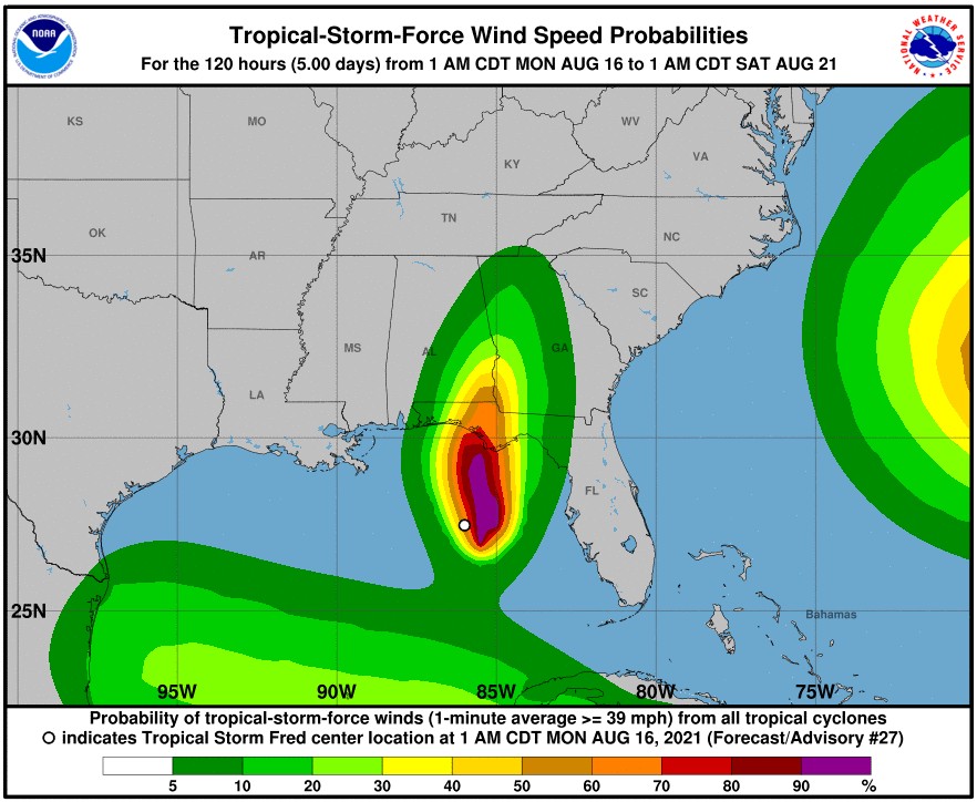
Swells generated by Fred are expected to reach the coasts of Mississippi, Alabama and the Florida Panhandle today, and could cause life-threatening surf and rip current conditions.
A tornado or two will be possible early this morning over the Florida west coast and Panhandle, and during the late morning and into the afternoon from the Florida Panhandle northward into southwest Georgia and southeast Alabama.
Featured image: Tropical Storm "Fred" at 10:20 UTC on August 16, 2021. Credit: NOAA/GOES-East, RAMMB/CIRA, TW
I would caution against using images from mainstream web sources. Those images are color enhanced to make the storm look worse than it is (top photo). Please don’t encourage them by reproducing this image as fact. The storm is much, much weaker than the picture you show above. Go look at the real-time weather map and you will see that it’s far less intense and dangerous. The images are created like the one above to create fear and sensationalism. They do it for every single storm. I live in Tampa and we’ve gotten less than an inch of rain, little wind and nothing else.