
Antarctic blast brings strong winds, snow, and flood-inducing rains to eastern Australia
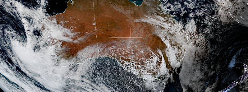
Image credit: JMA/Himawari-8, RAMMB/CIRA. Acquired at 05:30 UTC on June 8, 2021.
Cold weather is settling in across eastern Australia, focusing very much on snow, strong winds, and flood-inducing rains across multiple states, the Bureau of Meteorology (BOM) warned Tuesday, June 8, 2021. The wild weather is a result of an Antarctic cold pushed up from the Southern Ocean, prompting warnings across New South Wales, the Australian Capital Territory, Victoria, Tasmania, and Queensland.
In Victoria, wind gusts of around 80 km/h (50 mph) and freezing temperatures produced a snowstorm on Mt. Buller Monday, June 7, while temperatures around the state dropped below 10 °C (50 °F). East of Adelaide, heavy hail coated the streets on the Mount Lofty Ranges.
The powerful cold front, which originated in Antarctica, is expected to create a cut-off low-pressure system over NSW, which will gradually move east and produce rain, snow, and even hail across Victoria, NSW, and southern Queensland.
"Winter is well and truly here," said meteorologist Jonathon How on Tuesday.
"For today, South Australia, Victoria and Tasmania are going to see the wet, cold weather with plenty of hail and showers around."
"Wednesday and Thursday (June 9 and 10) will be the coldest for Sydney. Fourteen on Thursday and 12 through Western Sydney as well," he continued.
The cold front will bring powerful winds in South Australia, Tasmania, and Victoria, with gusts of up to 100 km/h (62 mph) possible in some areas.
The front's passage and the low-pressure system will also cause widespread rain across SA, NSW, the ACT, Victoria, Tasmania, and southern Queensland this week.
Heavy rain and thunderstorms are possible over Victoria and southeastern NSW on Wednesday as the system heads to the Tasman Sea.
"There's plenty of wet weather on the way, possible flooding across Gippsland later in the week so keep an eye on the warnings," added How.
Severe Weather Warnings have been issued for damaging winds and heavy rainfall across parts of #Victoria on Wednesday and Thursday as an East Coast Low develops off the east #Gippsland coast. Read the detailed warning information at https://t.co/eMiXnTn1V0 pic.twitter.com/sXWamZtc3Q
— Bureau of Meteorology, Victoria (@BOM_Vic) June 8, 2021
78km p/h winds whipping up a snow storm on Mt Buller. @9NewsMelb pic.twitter.com/UViYE6qd38
— Reid Butler (@reid_butler9) June 7, 2021
There’s been snow flurries all morning around Jamestown in the mid north.
Thanks to local Petrina for this video & keep warm! @9NewsAdel pic.twitter.com/NVjvfdcmIm
— Georgia Westgarth (@G_Westgarth) June 8, 2021
More showers for #Adelaide moving from the south with small hail possible. Take care on the roads and drive to the conditions. Keep up-to-date on the radar https://t.co/MOJ3wiGObz pic.twitter.com/0UmTOQ2KX9
— Bureau of Meteorology, South Australia (@BOM_SA) June 8, 2021
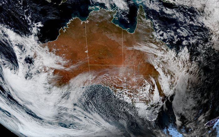
Image credit: JMA/Himawari-8, RAMMB/CIRA. Acquired at 05:30 UTC on June 8, 2021.
Up to 200 mm (8 inches) of rain is possible in just 12 hours overnight Wednesday into Thursday.
Many areas in the south and southeast are expected to shiver through below-freezing temperatures for at least two days this week, starting in South Australia and then spreading further north and east on Wednesday and Thursday.
Snow will also extend up ranges and tablelands in central and northern NSW, with some snow also possible in southern Queensland.
"We could see snow flurries across the Granite Belt tomorrow and into Thursday as well and frosty nights on the way for many Queenslanders."
"Damaging wind warnings are current across South Australia and western Victoria," BOM said.
"At the same time, a flood watch is active for northern Tasmania for minor flooding, and eastern Victoria in anticipation of minor to possibly major flooding."
"Further warnings will be issued as the situation evolves, particularly for eastern Victoria and southeast New South Wales, so be sure to have the latest information."
Not only Australia is getting snow in in June, Environment Canada is calling for cooler temperatures and rain this week but that rain is falling as snow at higher elevations in British Columbia. The majority of Canada is suffering an unusual June chill this week, as the Arctic rides anomalously-far south on the back of an unpredictable ‘meridional’ jet stream flow. It is unusual in Australia that temperatures are expected to tumble some 16C below the June average for central and eastern parts of New South Wales. While practically ALL of the Aussie continent should brace for an extreme chill by Wednesday. The Antarctic blast will also reach as far north as sub-tropical Queensland. Wrap up Australia, this will go down as your first Grand Solar Minimum winter (of the modern cooling epoch). The new reduction of the solar activity will lead to reduction of the solar irradiance by 3W/m2 according to Lean (1997). This results in significant cooling of Earth and very severe winters and cold summers. Several studies have shown that the Maunder Minimum coincided with the coldest phase of global cooling, which was called “the Little Ice Age”. Prepare for exceptional lows and snows, and flooding rains. Global warming is gone.