
Lava cuts off famous viewing hill of eruption near Fagradalsfjall in Geldingadalur, Iceland
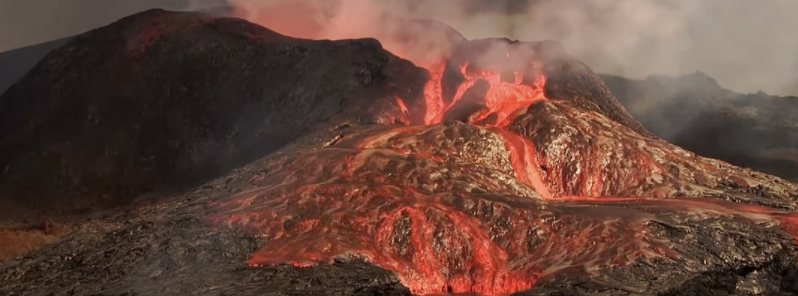
Image credit: mbl.is
The famous viewing hill providing a glimpse of the ongoing volcanic eruption site near Fagradalsfjall in Geldingadalur, Iceland, has been cut off as lava has made its way through the hiking trail on Monday, June 7, 2021. The spectacular sight of a volcano spewing lava at great heights has been attracting thousands of visitors to the area.
On Monday morning, responders were notified that lava has started flowing through the hiking trail that led up to the viewing hill where many tourists go to witness the erupting volcano in Geldingadalur.
The area was previously closed by authorities for safety purposes, due to the possibility of visitors being trapped on the hill if lava were to flow through the path.
Hjálmar Hallgrímsson, the site manager, told local media that lava had made its way over the trail very quickly. Fortunately, there were very few people at the eruption site.
Hikers will still be able to have a view of the volcano despite losing access to the viewing hill, renowned for its glimpse into the volcano's interior.
"There is no possibility of crossing this hill to see the eruption better," said Hjálmar. "This has become closed so it’s just a shorter route. But hiking trail A is still open, but for how long it is impossible to say. People can see the eruption from the hill next to it."
The historic volcanic eruption near Fagradalsfjall began on March 19, 2021, after more than 50 000 earthquakes registered since February 24. The last eruption in the area occurred in 1340 (VEI 1) – 681 years ago.
As the eruption continued, it produced a spectacular view of flowing lava, attracting many visitors to the site despite the hazard.
Powerful jets of lava have been observed, with some reaching unusual heights beyond 460 m (1 500 feet).
The volcanic eruption has also brought mesmerizing red skies over the area during cloudy days, leaving witnesses in awe, many of whom have taken to social media to share their photos and videos of the amazing scenery.
Drone captures its own demise while filming lava eruption at the mouth of Iceland's Fagradalsfjall volcano pic.twitter.com/f1HGlZkFlg
— Al Jazeera English (@AJEnglish) June 1, 2021
VIDEO: Aerial images of Iceland’s Fagradalsfjall volcano erupting and a partial crater rim collapsing into the lava pond pic.twitter.com/170gA0CNKb
— AFP News Agency (@AFP) June 2, 2021
Bucket list: stand next to an active volcano Fagradalsfgall, Iceland pic.twitter.com/vF0PQHvcM3
— Paula Watson MD (@watsonpl) June 6, 2021
Yesterday I got to witness one of our planet most spectacular feature. It was majestic, hypnotic and humbling. I am so lucky to be able to travel and sample with such a diverse group of people that give me access to these unique locations! #volcano #Iceland pic.twitter.com/7sMNVuiotM
— Donato Giovannelli (@d_giovannelli) June 1, 2021
Geldingadalir Volcano in Iceland is seriously getting wild now. Just look at the amount of lava it is gushing out. And that lava is flowing faster than you can run!
Anyone up for a dip? :p#Geldingadalir #Iceland #volcano pic.twitter.com/srmbAKD4pB
— Shark-Blade (@SharkBladeArts) June 8, 2021
Storm Chaser Captures Incredible Footage of Iceland’s Fagradalsfjall Volcano https://t.co/ik9Iik9a5T #iceland #volcano pic.twitter.com/ZYJR3SZBmY
— Terri Nakamura (@terrinakamura) June 7, 2021
#icelandvolcano #fagradalsfjall #icelanderuption #geldingadalir
Like translucent varnish – fresh lava in the morning sun. pic.twitter.com/icYR6XFPHM— FragenüberFragen (@FragenuberF) June 8, 2021
Geological summary
The Krýsuvík-Trölladyngja volcanic system is described by the Catalogue of Icelandic Volcanoes as an approximately 50 km (31 miles) long composite fissure swarm trending about N38°E, including a 30 km (18 miles) long swarm of fissures, with no central volcano.
It is one of the volcanic systems arranged en-echelon along the Reykjanes Peninsula west of Kleifarvatn lake.
The Fagradalsfjall and Krýsuvík fissure swarms are considered splits or secondary swarms of the Krýsuvík–Trölladyngja volcanic system.
Small shield volcanoes have produced a large portion of the erupted volume within the system.
Several eruptions have taken place since the settlement of Iceland, including the eruption of a large basaltic lava flow from the Ogmundargigar crater row around the 12th century.
The latest eruption, identified through tephrochronology, took place during the 14th century. (GVP)
Commenting rules and guidelines
We value the thoughts and opinions of our readers and welcome healthy discussions on our website. In order to maintain a respectful and positive community, we ask that all commenters follow these rules.