
Magma chamber continues to expand, more than 35 000 earthquakes hit Reykjanes Peninsula in two weeks, Iceland
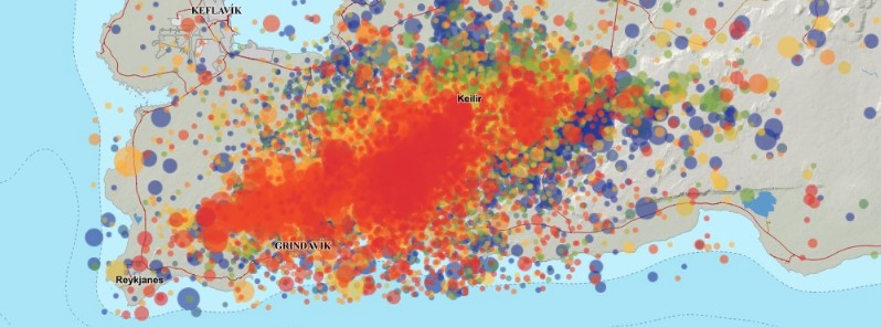
Image credit: IMO
The seismo-volcanic crisis on Reykjanes Peninsula, Iceland continues on March 11, 2021, with more than 35 000 earthquakes detected since February 24, 2021. The probability of an eruption is increasing and the most likely place where it might start is from Keilir to Fagradalsfjall.
The Scientific Council for Civil Protection met at a teleconference on March 10, concluding that as the current situation lasts longer, the probability of an eruption increases.
Processing of satellite images received on the morning of March 10 and the latest GPS measurements, confirm that magma is still restricted at the southern end of the magma channel that extends from Keilir to Fagradalsfjall.
This place is still considered to be the most likely place in the event of an eruption.
More earthquakes can be expected if the magma flow continues to expand and cause tension in the area.
Scientists said it is important to closely monitor the activity on the southern slopes of Fagradalsfjall to see if this activity is an indication that the magma channel is expanding to the south.
As the situation is assessed now, the magma is very shallow, at a depth of 1 – 1.5 km (0.6 – 0.9 miles).
It is important to realize that magma could break its way all the way to the surface without much seismic activity.
An example of this can be seen in the eruption that began at Fimmvörðuháls in 2010. At that time, there were no clear signs of the eruption on the Icelandic Met Office's measuring equipment and it was news from eyewitnesses that confirmed that magma had formed.
In this light, IMO has set up webcams that can be used to monitor if magma occurs.
More than 35 000 earthquakes were detected in the area since February 24, exceeding the number of earthquakes measured during the whole of 2020 — which was characterized by unusually high seismic activity.
In comparison, from 2014 to 2019, the number of earthquakes in the area was around 1 000 – 3 000 per year.
Geological summary
The Reykjanes volcanic system at the SW tip of the Reykjanes Peninsula, where the Mid-Atlantic Ridge rises above sea level, comprises a broad area of postglacial basaltic crater rows and small shield volcanoes.
The submarine Reykjaneshryggur volcanic system is contiguous with and is considered part of the Reykjanes volcanic system, which is the westernmost of a series of four closely-spaced en-echelon fissure systems that extend diagonally across the Reykjanes Peninsula.
Most of the subaerial part of the volcanic system (also known as the Reykjanes/Svartsengi volcanic system) is covered by Holocene lavas.
Subaerial eruptions have occurred in historical time during the 13th century at several locations on the NE-SW-trending fissure system, and numerous submarine eruptions at Reykjaneshryggur dating back to the 12th century have been observed during historical time, some of which have formed ephemeral islands.
Basaltic rocks of probable Holocene age have been recovered during dredging operations, and tephra deposits from earlier Holocene eruptions are preserved on the nearby Reykjanes Peninsula. (GVP)
I'm a dedicated researcher, journalist, and editor at The Watchers. With over 20 years of experience in the media industry, I specialize in hard science news, focusing on extreme weather, seismic and volcanic activity, space weather, and astronomy, including near-Earth objects and planetary defense strategies. You can reach me at teo /at/ watchers.news.
Commenting rules and guidelines
We value the thoughts and opinions of our readers and welcome healthy discussions on our website. In order to maintain a respectful and positive community, we ask that all commenters follow these rules.