
Tropical Storm “Nivar” expected to cross Tamil Nadu and Puducherry coasts on November 25, India
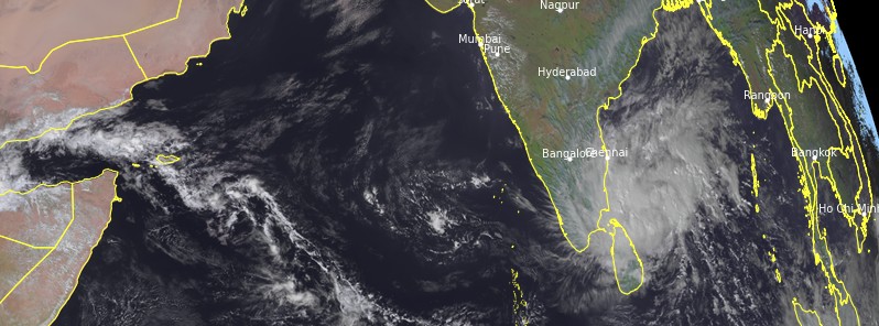
Featured image: Tropical Storm "Nivar" at 09:30 UTC on November 24, 2020. Credit: EUMETSAT/Meteosat-8, RAMMB/CIRA, TW
Tropical Storm "Nivar" formed in the Bay of Bengal on November 24, 2020, prompting the Indian Meteorological Department (IMD) to issue cyclone warnings for the coast of Tamil Nadu, Pondicherry, and Sri Lanka. Nivar is the fourth named storm of the below-average 2020 North Indian cyclone season. It formed just 2 days after the historic explosive intensification and landfall of Tropical Cyclone "Gati" in Somalia.
- Nivar is expected to cross the Tamil Nadu-Puducherry coasts between Karaikal and Mamallapuram as a very severe cyclonic storm on Wednesday, November 25.
- Fairly widespread to widespread rainfall/thunderstorm activity very likely over coastal and north interior Tamil Nadu, Puducherry, and Karaikal from November 24 to 26 and over south coastal Andhra Pradesh, Rayalaseema from November 25 to 26, and southeast Telangana on November 26, 2020.
- A tidal wave of about 1 – 1.5 m (3.3 – 4.9 feet) height above the astronomical tide is very likely to inundate the low lying areas of north coastal districts of Tamil Nadu and Puducherry near the place of landfall.
At 09:00 UTC on November 24, the center of Tropical Storm "Nivar" was located about 370 km (230 miles) ESE of Puducherry and 420 km (261 miles) SSE of Chennai, India. IMD expects the system to intensify into a severe cyclonic storm during the next 12 hours and into a very severe cyclonic storm during the subsequent 12 hours.
Over the next 12 hours, Nivar is very likely to move WNW and then turn NW.
IMD forecasters expect it to cross Tamil Nadu and Puducherry coasts between Karaikal and Mamallapuram around Puducherry late evening (LT) on November 25 as a very severe cyclonic storm with a wind speed of 120 – 130 km/h (75 – 80 mph) and gusts to 145 km/h (90 mph).

Tropical Storm "Nivar" at 09:30 UTC on November 24, 2020. Credit: EUMETSAT/Meteosat-8, RAMMB/CIRA, TW
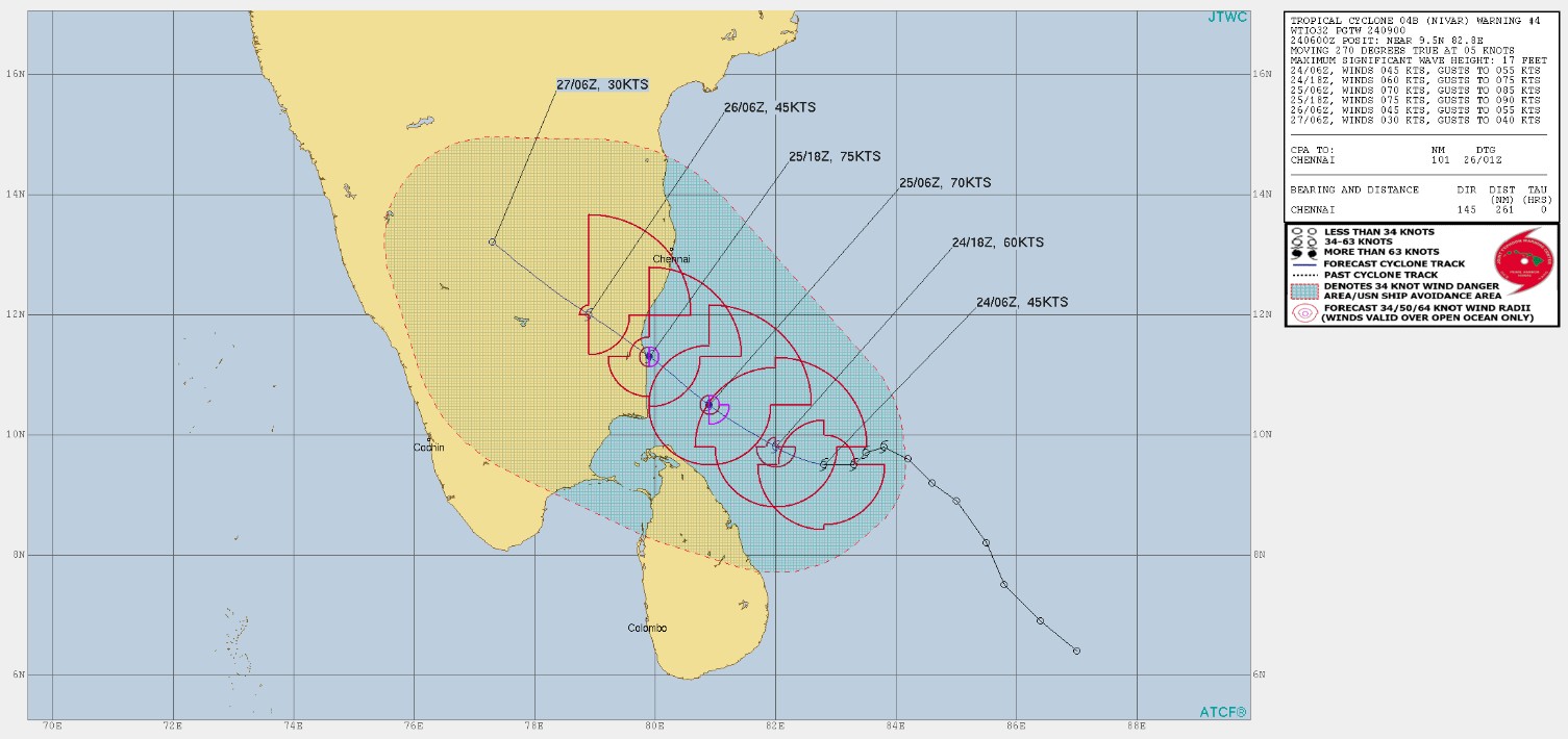
Image credit: JTWC
Fairly widespread to widespread rainfall/thunderstorm activity very likely over coastal and north interior Tamil Nadu, Puducherry, and Karaikal from November 24 to 26. Over south coastal Andhra Pradesh, Rayalaseema from November 25 to 26, and southeast Telangana on November 26, 2020.
Isolated extremely heavy rainfall activity also very likely over coastal and north interior Tamil Nadu and Puducherry (Pudukottai, Thanjavur, Tiruvarur, Karaikal, Nagapattinam, Cuddalore, Ariyalur and Perabalu districts on November 24 and Kadalur, Kallakurchi, Puducherry, Villupuram, Tiruvannamalai, Chengalpattu to Ariyalur, Perambalur and Karaikal districts) on the 25th; over Nellore and Chittoor districts of Andhra Pradesh on the 25th and over Rayalseema and southeast Telangana on November 26.
Gale wind speed reaching 75 – 85 km/h (45 – 53 mph) with gusts to 95 km/h (59 mph) is prevailing over Southwest Bay of Bengal. The winds are expected to further increase to 110 – 120 km/h (68 – 75 mph), gusts to 135 km/h (84 mph) over the southwest Bay of Bengal from the morning of November 25, and increasing to 120 – 130 km/h (75 – 80 mph) with gusts to 145 km/h (90 mph) from 12:00 LT to the night of November 25.
Sea condition is high over Southwest Bay of Bengal and rough to very rough along and off Tamil Nadu, Puducherry, south Andhra Pradesh coasts, and over Gulf of Mannar. It would gradually become very high over the southwest Bay of Bengal from the night of November 24 (LT) and phenomenal over the same area from noon to the night of November 25th.
A tidal wave of about 1 – 1.5 m (3.3 – 4.9 feet) height above the astronomical tide is very likely to inundate the low lying areas of north coastal districts of Tamil Nadu and Puducherry near the place of landfall.
Damage expected over Nagapattinam, Myladuthurai, Cuddalore, Villupuram, and Chengalpattu districts of Tamil Nadu and Karaikal, and Puducherry:
- Total destruction of thatched houses/ extensive damage to kutcha houses. Some damage to old pucca houses. The potential threat from flying objects.
- Bending/ uprooting of power and communication poles.
- Major damage to Kutcha and Pucca roads. Flooding of escape routes. Disruption of railways, overhead powerlines, and signaling systems.
- Widespread damage to standing crops, plantations, orchards, falling of green coconuts, and tearing of palm fronds. Blowing down of bushy trees like mango.
- Small boats, country crafts may get detached from moorings.
- Visibility severely affected.
Damage expected over Tiruvarur, Kanchipuram, Chennai, Tiruvallaur districts of Tamil Nadu, and adjoining Andhra Pradesh:
- Damage to thatched houses/ huts with the possibility of rooftops being blown off and unattached metal sheets may fly.
- Damage to power and communication lines.
- Damage to Kutcha and some damage to Pucca roads. Flooding of escape routes.
- Breaking of tree branches, uprooting of trees. Severe damage to banana and papaya trees, horticulture, and crops and orchards. Large dead limbs blown from trees.
- Major damage to coastal crops. Damage to embankments/salt pans.
Fishermen Warning and Action Suggested:
- Total suspension of fishing operations.
- Mobilize evacuation from coastal areas. Coastal hutment dwellers to be moved to safer places.
- People in affected areas to remain in safe places and indoors.
- Judicious regulation of rail, road, and air traffic.
- Movement in motorboats and small ships unsafe.
I'm a dedicated researcher, journalist, and editor at The Watchers. With over 20 years of experience in the media industry, I specialize in hard science news, focusing on extreme weather, seismic and volcanic activity, space weather, and astronomy, including near-Earth objects and planetary defense strategies. You can reach me at teo /at/ watchers.news.
Commenting rules and guidelines
We value the thoughts and opinions of our readers and welcome healthy discussions on our website. In order to maintain a respectful and positive community, we ask that all commenters follow these rules.