Severe Cyclonic Storm “Nisarga” makes historic landfall close to Mumbai, India
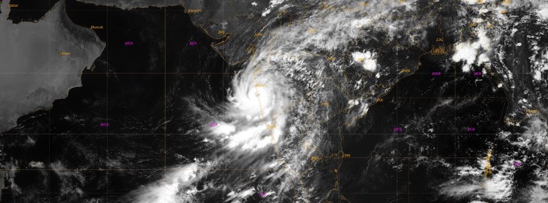
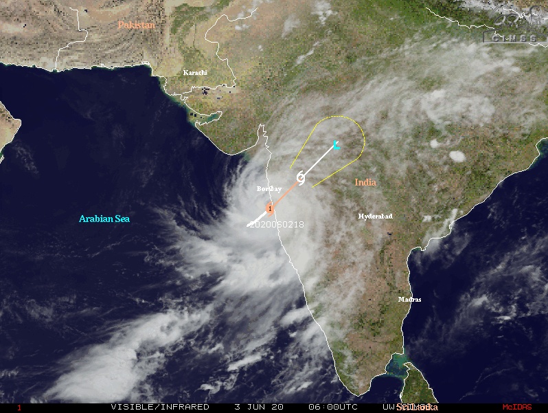
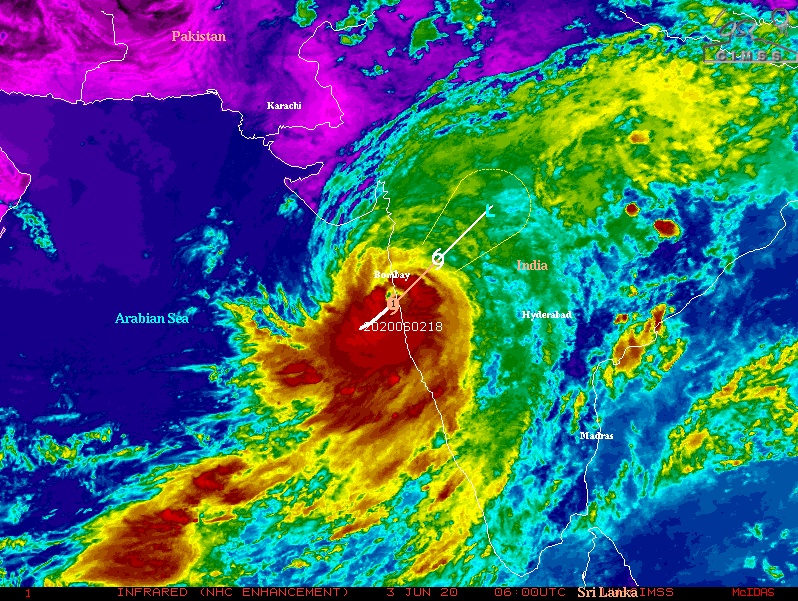
Severe Cyclonic Storm "Nisarga" made historic landfall over Maharashtra, India just south of Alibagh at 07:30 UTC on June 3, 2020, with maximum sustained wind speeds up to 110 km/h (70 mph) and gusts to 120 km/h (75 mph). The landfall process will be completed during the next three hours. After the landfall, Nisarga is very likely to maintain its Cyclonic Storm intensity for about 6 hours, while moving north-northeastwards across north Madhya Maharashtra.
Storm surge of about 1 – 2 m (3.3 – 6.6 feet) above astronomical tide is very likely to inundate low lying areas of Mumbai, Thane and Raigad districts and 0.5 – 1 m (1.6 – 3.3 feet) above the astronomical tide likely to inundate low lying areas of Ratnagiri district during the time of landfall.
Nisarga's center passed very close to Mumbai, a megacity and India's commercial center with a population of 18 million, rarely impacted by tropical cyclones. In addition, this is its first time in recorded history to be struck by a tropical cyclone during the month of June.
In total, just three tropical cyclones have made landfall over or near Mumbai since 1891 — all three in October and November. The latest was Tropical Cyclone "Phyan" on November 11, 2009, resulting in mass evacuations and massive damage to property in the districts of Ratnagiri, Raigad, Sindhudurg, Thane and Palghar.
Mumbai has banned all public movement until the storm threat is over. Rooftops were seen flying off in Alibagh as Nisarga made landfall, along with high waves and heavy rainfall.
SCS Nisarga Satellite animation pic.twitter.com/RoW6MPJofW
— India Met. Dept. (@Indiametdept) June 3, 2020
RAINFALL CONTINUING IN MAHARASHTRA COAST.
MUMBAI (COLABA) REPORTED 72 KMPH WIND SPEED AT 12:30 IST. pic.twitter.com/IqNiMTyktR— India Met. Dept. (@Indiametdept) June 3, 2020
#WATCH: #CycloneNisarga makes landfall along the Maharashtra coast, process will be completed during next 3 hours. Visuals from Alibaug. pic.twitter.com/n5kpRtpBdS
— ANI (@ANI) June 3, 2020
Officials are urging residents to pay attention to official instructions and not pay heed to rumors or circulate them.
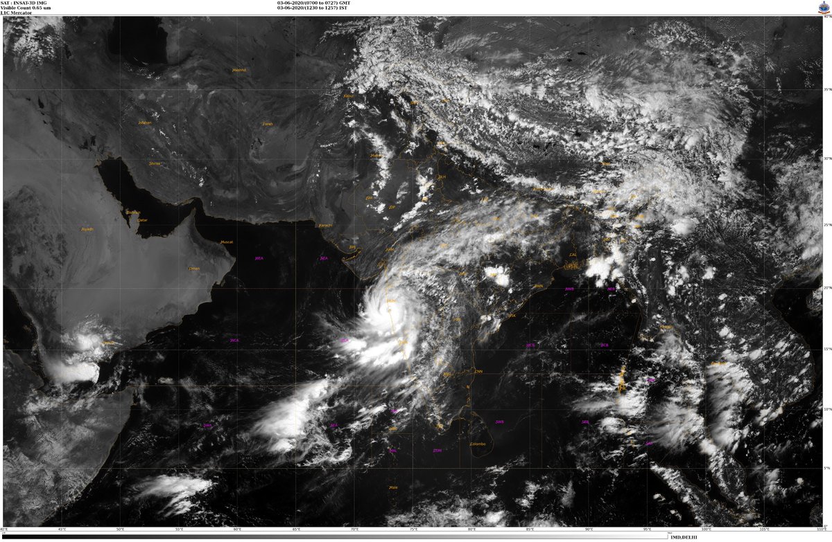
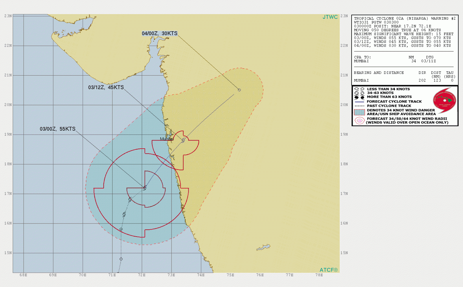
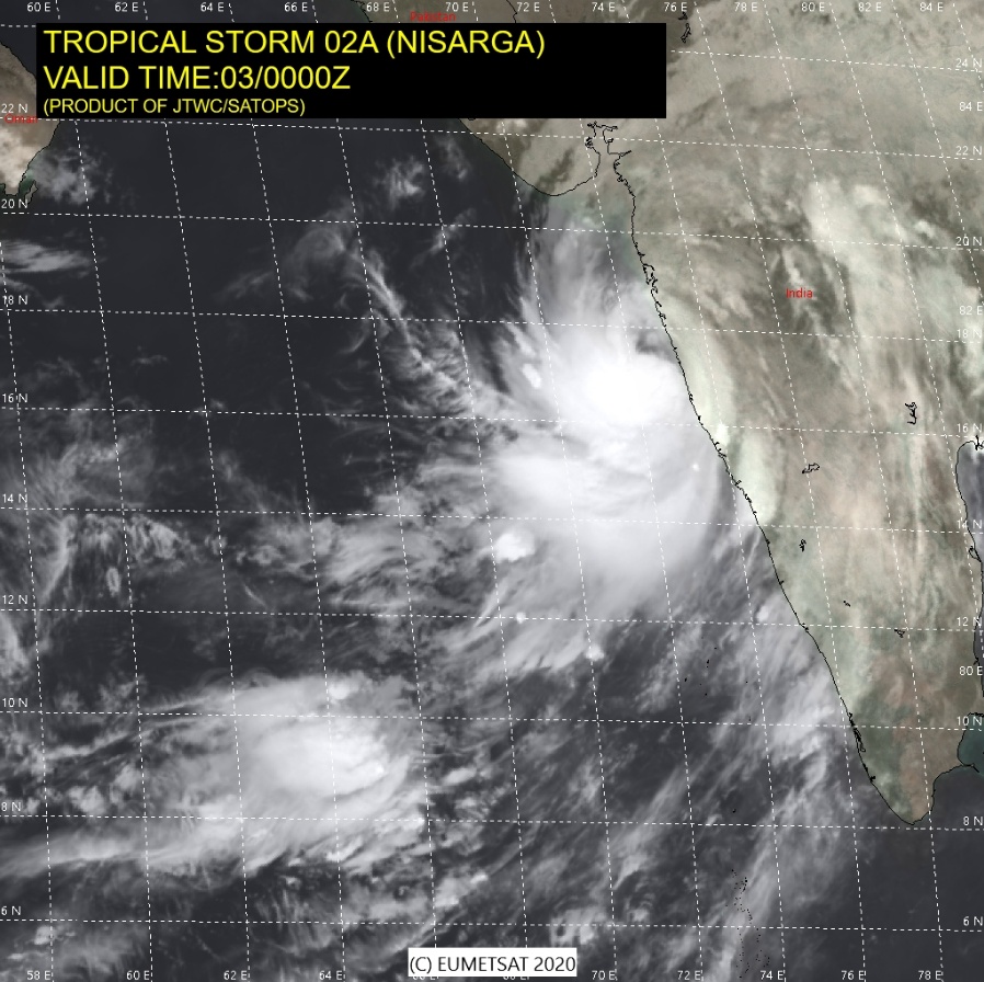
Over the past 6 hours, Nisarga moved northeastward over the East-central Arabian Sea at a speed of 13 km/h (8 mph) and was centered about 130 km (80 miles) SSW of Allibagh, 170 km (105 miles) SSW of Mumbai, Maharashtra and 400 km (250 miles) SSW of Surat, Gujarat at 03:00 UTC (08:30 IST) on June 3.
Tropical Cyclone "Nisarga" at 07:15 UTC on June 3, 2020. Credit: ISRO/RAPID
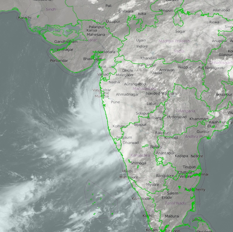
Light to moderate rainfall is forecast at most places with heavy to very heavy falls at a few places and extremely heavy falls ( ≥ 200 mm / 8 inches in 24 hours) at isolated places very likely over north Konkan (Mumbai, Palghar, Thane, Raigad districts) and north Madhya Maharashtra during next 24 hours.
Light to moderate rainfall is expected at most places with heavy to very heavy falls at isolated places over south Konkan (Ratnagiri and Sindhudurg districts), Goa and south Gujarat region (Valsad, Navsari, Dang, Daman, Dadra and Nagar Haveli and Surat districts) during next 24 hours.
Light to moderate rainfall at most places with heavy falls at isolated places is also expected over west Madhya Pradesh and Vidarbha during next 24 hours.
Gale wind, speed reaching 100 – 110 km/h (60 – 70 mph) gusting to 120 km/h (75 mph), is prevailing over Eastcentral Arabian Sea. From the noon (LT) on June 3, it will become Gale wind, speed reaching 100 – 110 km/h (70 mph) gusting to 120 km/h (75 mph) over eastcentral Arabian Sea along and off north Maharashtra coast (Raigad, Mumbai and adjoining Thane), 85 – 95 km/h (53 – 60 mph) gusting to 105 km/h (65 mph) along and off Ratnagiri, Sindhudurg, Palghar and remaining areas of Thane.
Gale wind, speed reaching 60 – 80 km/h (37 – 50 mph) gusting to 90 km/h (56 mph), likely along and off Valsad, Navsari districts of Gujarat, Daman, Dadra and Nagar Haveli and along and off northeast Arabian Sea and 60 -70 km/h (37 – 45 mph) gusting to 80 km/h (50 mph) along and off Surat and Bharuch districts of south Gujarat from noon (LT) today.
Squally wind, speed reaching 50 – 60 km/h (30 – 37 mph) gusting to 70 km/h (45 mph) is likely to prevail over northeast Arabian Sea along and off remaining districts of south Gujarat coast today.Squally wind, speed reaching 50 – 60 km/h (30 – 37 mph) gusting to 70 km/h (45 mph) is likely to prevail over the east-central Arabian Sea along and off Karnataka-Goa coasts during next 12 hours.
The Sea condition will be High to Very High over the east-central Arabian Sea and along and off Maharashtra and Goa coasts; and Very Rough to High over the northeast Arabian Sea along and off south Gujarat coast until evening hours of June 3 (LT).
Storm surge of about 1 – 2 m (3.3 – 6.6 feet) above astronomical tide is very likely to inundate low lying areas of Mumbai, Thane and Raigad districts and 0.5 – 1 m (1.6 – 3.3 feet) height above the astronomical tide likely to inundate low lying areas of Ratnagiri district during the time of landfall.
Fishermen are advised not to venture into East-central and Northeast Arabian Sea and along and off Karnataka-Goa-Maharashtra-south Gujarat coasts during the next 24 hours.
Damage expected:
- Major damage to thatched houses/ huts. Rooftops may blow off. Unattached metal sheets may fly.
- Damage to power and communication lines.
- Major damage to Kutcha and some damage to Pucca roads. Flooding of escape routes.
- Breaking of tree branches, uprooting of large avenue trees. Damage to banana and papaya trees. Large dead limbs blown from trees.
- Major damage to coastal crops.
- Damage to embankments/ salt pans.
Fishermen warning and action suggested: Total suspension of fishing operations. Mobilize evacuation from low lying areas. Judicious regulation of rail and road traffic. People in affected areas to remain indoors. Movement in motor boats and small ships unsafe.
After the landfall, the Severe Cyclonic Storm is very likely to maintain its Cyclonic Storm intensity for about 6 hours, while moving north-northeastwards across north Madhya Maharashtra.
Under its influence Gale wind reaching 60 – 70 km/h (37 – 45 mph) gusting to 80 km/h (50 mph) very likely to prevail over Pune, Ahmadnagar and 55 – 65 km/h (35 – 40 mph) gusting to 75 km/h (46 mph) adjoining Beed, Nashik and Aurangabad districts of Maharashtra. Light to moderate rainfall at most places with heavy to very heavy falls at isolated places are also very likely over these districts on June 3.
Interior districts of Maharashtra (Pune, Ahmadnagar, Nashik, Aurangabad and adjoining Beed) can expect minor damage to power and communication lines, damage to Kutcha, and some damage to Pucca roads, breaking of tree branches, uprooting of small trees, damage to banana and papaya trees. People in affected areas should remain indoors.
Nisarga is the second named storm of the 2020 North Indian Ocean cyclone season.
Featured image credit: IMD
Commenting rules and guidelines
We value the thoughts and opinions of our readers and welcome healthy discussions on our website. In order to maintain a respectful and positive community, we ask that all commenters follow these rules.