
Early winter blast, record rain hit much of the eastern seaboard of Australia, severe weather to continue into weekend
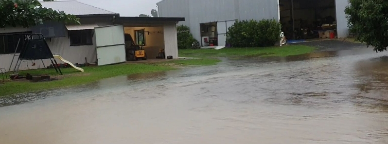
Image credit: Chris Bolton
Much of the eastern seaboard of Australia was hit by wet weather overnight into May 20, 2020, as a cold front generated rains across Victoria, New South Wales, and Queensland. The severe weather conditions are forecast to last until the weekend as the country experiences an early winter blast. Queensland, in particular, recorded 450 mm (1.5 feet) of rain in a 48-hour period to May 22– its highest two-day rainfall total in 29 years.
In Queensland, heavy rainfall lashed parts of the northern region, prompting flood warnings in some areas. Flooding was reported in parts of the North Tropical Coast.
The intense downpours were due to a deep layer of moisture-laden air over the north, interacting with a low trough near the North Tropical Coast.
Some areas received more than 500 mm (1.6 feet) of rain in a 48 hour period to Thursday morning, May 21. Around 520 m (1.7 feet) of rain was registered at Bulgan Creek near Tully.
Around 450 m (1.5 feet) of rain was recorded at Bingil Bay, making it the highest two-day total in 29 years and its highest during the month of May since record-keeping began in 1926.
The two-day downpour included 300 mm (1 foot) in a 24 hour period, which is also a new record for May.
As of 00:00 UTC (10:00 LT), flood warnings had been in place for the Mulgrave, Russell, and Tully Rivers. Rains are expected over the region into Sunday, May 24, but falls will not be as heavy as the previous ones.
This from fisherman Chris Bolton at Kurrimine Beach: who nearly could have launched his reef boat into Maria Creek from the back door this morning! Over 300mm of rain at nearby Bingil Bay recorded to 9am this morning, falls now slowing @FarOutQld pic.twitter.com/gJXssZr9d9
— Tom Major (@thomaslmajor) May 21, 2020
Queensland expecting more rain over coming days with 100-300mm already recorded until 9am btwn Cairns and Ingham. Highest total 338mm at Bulgan Creek. Temps also expected to be abt 6-10C below average for parts. View #QldWeather updates: https://t.co/8r66rjIJhr pic.twitter.com/ucW6XSLOvV
— Bureau of Meteorology, Queensland (@BOM_Qld) May 20, 2020
In New South Wales, heavy rain is forecast to settle in on Friday, May 22, with the Harbour City likely to see up to 60 mm (2.4 inches) of rain. Hazardous conditions are expected for coastal activities, including rock fishing, surfing, and swimming.
Wind warnings are in force along the Sydney and Illawarra coasts, while a gale warning is in effect for the coasts of Macquarie, Hunter, Batemans, and Eden.
There will be a slight chance of showers by Saturday, May 23, but heavy rainfall is likely to come back on Sunday, May 24, with winds forecast to intensify across much of the region.
It's a bit wet in #Sydney this afternoon, with rain at times and the chance of a storm.
Don't put that umbrella away tonight – a Tasman Low is forecast to make Friday, especially in the morning, wet and windy.
Sydney forecast: https://t.co/H4S9UgW1fw pic.twitter.com/ZekgLIDiZM— Bureau of Meteorology, New South Wales (@BOM_NSW) May 21, 2020
As a cold front reaches the Tasman Sea tonight, a low is expected to deepen off the southern or central #NSW coast.
Coastal areas, particularly central parts, may experience heavy rain, vigorous winds, and large surf.
Latest NSW warnings and forecast: https://t.co/4AJoS61Um5 pic.twitter.com/LZGL3jEMUo— Bureau of Meteorology, New South Wales (@BOM_NSW) May 21, 2020
In Victoria, up to 60 homes were severely damaged as storms hit the western portion overnight into May 20. Four of the houses were deemed uninhabitable, prompting relocation for the affected residents.
The worst-affected areas were Waurn Ponds and Mount Duneed, with the State Emergency Service (SES) accommodating 115 calls for help.
Conditions across the state have eased as of May 21, but showers are likely to return on Friday afternoon. Rains will also make a comeback on the weekend, with showers expected for much of Saturday.
Victoria has been hit by heavy rain, strong wind gusts, and lightning- and thunderstorms, as part of the cold front sweeping through Australia's south and south-east. @IzaStaskowski #9News pic.twitter.com/7mKtFVaTK3
— Nine News Queensland (@9NewsQueensland) May 19, 2020
For three hours on Tuesday night, residents in Victoria’s west copped a battering from extreme weather. The cold front packed a punch with lightning, rain and high winds. https://t.co/DTq2zeaIIw @GeorgiaComensol #7NEWS pic.twitter.com/WgX2GEysl9
— 7NEWS Central Queensland (@7NewsCQ) May 20, 2020
Commenting rules and guidelines
We value the thoughts and opinions of our readers and welcome healthy discussions on our website. In order to maintain a respectful and positive community, we ask that all commenters follow these rules.