Eruption at Kuchinoerabujima volcano, Japan
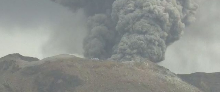
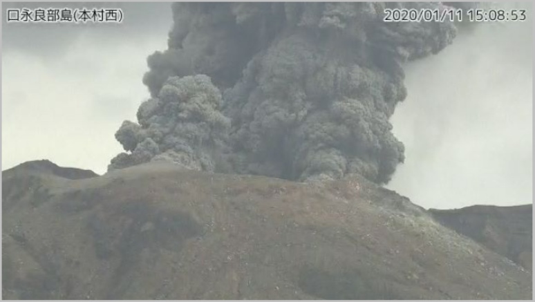
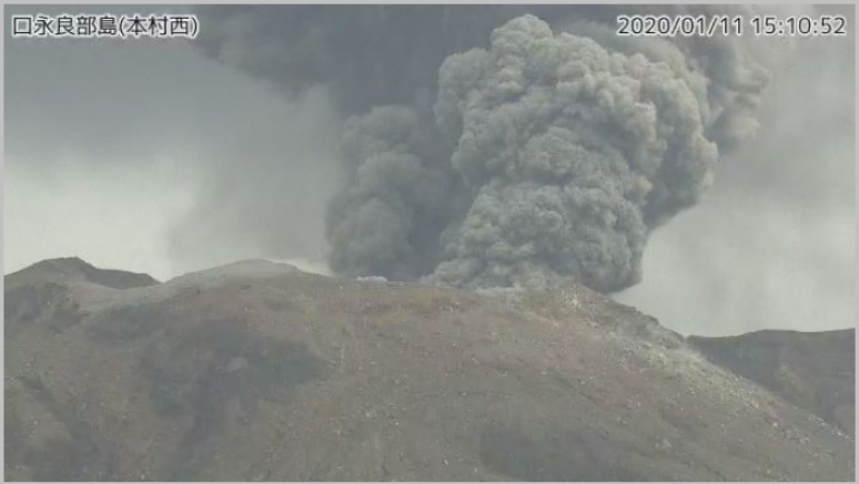
Japan's Kuchinoerabujima volcano erupted at 06:05 UTC on January 11, 2020, ejecting volcanic material up to 300 m (984 feet) from the crater of Mount Shindake. This is the first eruption at the volcano since February 2, 2019. Kuchinoerabujima is a volcano island in Satsunan Islands, Japan, about 120 km (75 miles) SSW of Kagoshima city and about 1 100 km (685 miles) WSW of Tokyo. A series of eruptions with pyroclastic flows were recorded in December 2018 and January 2019.
Volcanic ash cloud reached up to 2.7 km (9000 feet) above sea level.
There were no pyroclastic flows produced and no evacuation orders were issued, the Japan Meteorological Agency (JMA) said.
Images courtesy Japan Meteorological Agency
The Alert Level remains at 3 (on a scale of 5) since 15:15 UTC on October 27, 2019 (00:15 JST, October 28), after a large earthquake hit the island.
"There is a possibility that an eruption will occur of a magnitude similar to the one in January when pyroclastic flows reached a point 1.9 km (1.2 miles) from the crater," JMA said at the time.
In 2015, pyroclastic flows reached all the way to the coast, forcing all residents to evacuate.
Significant explosive eruption just now at the restless Kuchinoerabu #volcano in #Japan images via JMA webcam. H/t @wataruen pic.twitter.com/m1nr3bp3VT
— James Reynolds (@EarthUncutTV) January 17, 2019
Residents (currently about 100 of them) and tourists are warned not to approach the danger zone.
Geological summary
A group of young stratovolcanoes forms the eastern end of the irregularly shaped island of Kuchinoerabujima in the northern Ryukyu Islands, 15 km (9.3 miles) west of Yakushima. The Furudake, Shindake, and Noikeyama cones were erupted from south to north, respectively, forming a composite cone with multiple craters.
The youngest cone, centrally-located Shintake, formed after the NW side of Furutake was breached by an explosion. All historical eruptions have occurred from Shintake, although a lava flow from the S flank of Furutake that reached the coast has a very fresh morphology.
Frequent explosive eruptions have taken place from Shintake since 1840; the largest of these was in December 1933. Several villages on the 4 x 12 km (2.5 x 7.5 miles) island are located within a few kilometers of the active crater and have suffered damage from eruptions. (GVP)
Featured image credit: JMA
Commenting rules and guidelines
We value the thoughts and opinions of our readers and welcome healthy discussions on our website. In order to maintain a respectful and positive community, we ask that all commenters follow these rules.