
Powerful eruption at Taal volcano, volcanic ash to 16.7 km (55 000 feet) a.s.l., Philippines
Featured image: Taal volcano erupting on January 12, 2020. Credit: Angelo Mendoza Cabrera
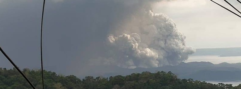
Taal volcano in the Philippines started erupting at 06:04 UTC on January 12, 2020, for the first time since 1977. The volcanic ash cloud is reaching up to 16.7 km (55 000 feet) above sea level, according to data provided by the Tokyo VAAC.
- PHIVOLCS said it strongly recommends Taal Volcano Island and high-risk barangays of Agoncillo and Laurel, Batangas be evacuated due to the possible hazards of pyroclastic density currents and volcanic tsunami.
- Taal has produced some of the Philippines' most powerful eruptions. Powerful pyroclastic flows and surges from historical eruptions have caused many fatalities. Its last eruption took place in 1977 (VEI2).
The eruption generated a plume up to 1 km (3 500 feet), accompanied by volcanic tremor and felt earthquakes in Volcano Island and barangays of Agoncillo, Batangas. Ashfall is currently being showered on the southwest sector of Taal, PHIVOLCS said in a bulletin released at 08:04 UTC.
At 09:00 UTC, the Tokyo VAAC reported it has updated volcanic ash height to 16.7 km (55 000 feet) a.s.l. based on satellite data (08:20 UTC) and numerical weather prediction.
Taal volcano erupts! I'm here at Puerto Galera with my workfriends rn. I am afraid. Let's all pray… pic.twitter.com/YaEH0nec4s
— 전 사라 ⁷ (@seokjanekook) January 12, 2020
¿Por qué se producen rayos en una erupción volcánica?
La expulsión y fricción entre partículas y gases genera estática y separación de cargas (+|-) resultado = descargas eléctricas “rayos”#TaalVolcanoEruption #Taal
Créditos fotos: ABS-CBN News pic.twitter.com/Da6HqbMeQs— Geól. Sergio Almazán (@chematierra) January 12, 2020
Taal volcano seismic network has manifested moderate to high level of seismic activity since March 28, 2019. Some of these earthquakes were felt with intensity ranging from Intensity I (Scarcely Perceptible) to Intensity III (Weak Shaking) in the barangays of Calauit, Balete, Sitio Tibag, Pira-Piraso, and Buco, Talisay, Alas-as and Pulangbato, San Nicolas, Batangas. Often, these felt earthquakes are accompanied by rumbling sounds.
Three felt earthquake were recorded over the past 12 hours – at 23:35 UTC on January 11, 02:43 and 06:00 UTC on January 12.
A seismic swarm has started at around 03:00 UTC (11:00 LT).
PHIVOLCS raised the Alert Level at 08:00 UTC to 3 – this means that there is a magmatic intrusion that is likely driving the current activity.
The Institute said it strongly recommends Taal Volcano Island and high-risk barangays of Agoncillo and Laurel, Batangas be evacuated due to the possible hazards of pyroclastic density currents and volcanic tsunami.
The public is reminded that the entire Volcano Island is a Permanent Danger Zone (PDZ), and entry into the island as well as high-risk barangays of Agoncillo and Laurel is prohibited.
In addition, communities around the Taal Lake shore are advised to take precautionary measures and be vigilant of possible lakewater disturbances related to the ongoing unrest.
Update:
PHIVOLCS raised the Alert Level from 3 (magmatic unrest) to 4 (hazardous eruption imminent) at 11:30 UTC. This means that hazardous explosive eruption is possible within hours to days.
DOST-PHIVOLCS strongly reiterates total evacuation of Taal Volcano Island and additional evacuation of areas at high risk to pyroclastic density currents and volcanic tsunami within a 14 km (8.7 miles) radius from Taal Main Crater.
Areas in the general north of Taal Volcano are advised to guard against the effects of heavy and prolonged ashfall. Civil aviation authorities must advise aircraft to avoid the airspace around Taal Volcano as airborne ash and ballistic fragments from the eruption column pose hazards to aircraft.
As of 09:30 UTC (17:30 LT), eruptive activity at Taal Volcano Main Crater intensified as continuous eruption generated a tall 10-15 km (33 000 – 49 000 feet) steam-laden tephra column with frequent volcanic lightning that rained wet ashfall on the general north as far as Quezon City, PHIVOLCS reported.
Volcanic tremor was recorded continuously since 03:00 UTC and two volcanic earthquakes of magnitudes M2.5 and M3.9 were felt at Intensity III in Tagaytay City and Alitagtag, Batangas were recorded at 10:15 and 10:22 UTC (18:15 and 18:22 PST), respectively.
Ashfall was reported in Metro Manilla (100 km / 62 miles) N of Taal.
All flights at Ninoy Aquino International Airport are on a delay, and passengers advised to coordinate with airlines for updates.
Evacuations are underway in the municipalities of San Nicolas, Balete and Talisay.
Classes within the provinces of Cavite, Batangas, Rizal and Laguna will be canceled on Monday, Januar 13. due to heavy ashfall.
Manila City Mayor Isko Moreno has also ordered the suspension of classes in all levels of public and private schools on Monday.
"Magma is intruding from below. If eventually this will continue to move up, then there can be a magmatic eruption which is more dangerous," PHIVOLCS head Renato Soldium said.
beautiful disaster #TaalVolcano #TaalEruption #Taal pic.twitter.com/ayQitGOxzr
— (@gummyeontan) January 12, 2020
#Update: And here is a time-lapse video of over a period of 4 hours taken from the ash spewing volcano of #Taal in the #Philippines. pic.twitter.com/DIQqk9QhEs
— Sotiri Dimpinoudis (@sotiridi) January 12, 2020
Pray for my beloved hometown Laurel Batangas, at sa mga kalapit bayan po. Sobrang nakakatakot po talaga may ilang miyembro ng pamilya kami na nagpaiwan. Nakakaiyak po. May mga stranded dahil sira na po ang mga dadaanan #PrayForBatangas #prayforlaurelbatangas #taal pic.twitter.com/kXf3477rqm
— Lineth B (@lin_bata) January 12, 2020
Geological summary
Taal is one of the most active volcanoes in the Philippines and has produced some of its most powerful historical eruptions. Though not topographically prominent, its prehistorical eruptions have greatly changed the topography of SW Luzon. The 15 x 20 km (9 x 12 feet) Talisay (Taal) caldera is largely filled by Lake Taal, whose 267 km2 (103 mi2) surface lies only 3 m (9.8 feet) above sea level.
The maximum depth of the lake is 160 m (525 feet), and several eruptive centers lie submerged beneath the lake. The 5-km-wide (3.1 miles) Volcano Island in north-central Lake Taal is the location of all historical eruptions. The island is composed of coalescing small stratovolcanoes, tuff rings, and scoria cones that have grown about 25% in the area during historical time. Powerful pyroclastic flows and surges from historical eruptions have caused many fatalities. (GVP)
I'm a dedicated researcher, journalist, and editor at The Watchers. With over 20 years of experience in the media industry, I specialize in hard science news, focusing on extreme weather, seismic and volcanic activity, space weather, and astronomy, including near-Earth objects and planetary defense strategies. You can reach me at teo /at/ watchers.news.
Why you did not publish my commentary before 10 hours ? What a shit administrator must it be to hide the facts about volcano?????!!!!!!
You have to be a registered user to have instant comments.
It seems, the Taal volcano had shown a mighty explosion, only current in flash from ash cloud
has intensity 248,2375 amper per meter. 1 km long flash has 248,2375 kiloamper. But main canal of energy consist in earthquake (or earthquake swarms) and in magma energy. 25 earthquakes 3.6 magnitudo in diameter generated energy 566170 Joules per second square meter, for example in circle 10 km in 3 minut lasting is total energy 32016159228292798,280767106477604 Joules = 3,201616 e17 Joules = 80,0404 Megatun of TNT. Magma produced thermal energy 5 billion Joule per m3 (cubic metre).
excellent twitter video find. All that lightning!
can add this to my list of volcanoes that have been dormant for awhile (up to hundreds of years I think) and woken up. 40+ year dormancy and now waking up…hmm…. I have at least 10 from just the last few years.
Have a plan to find the rest / others on the SI website. Just need to sit down and do it.
Imo, we are in a period of time where the probability for large eruptions is greatly increased. Not sure if there would be any way to prove how this works, but there is good correlation that eruptions are most likely during a Gleissberg cycle, or a solar grand minimum.
I would say that this is evidence that a Gleissberg cycle is now in place, and that a large eruption such as this one could induce the effects of a grand minimum. Maybe this is what a grand minimum is all about. It is a Gleissberg which is impacted by a large eruption at a sensitive location, at just the right time. Then instead of an approximately 15 years of cooling we get around 30 years of global cooling, and we call that a solar grand minimum.