Dangerous storm surge and tropical-storm-force winds expected along portions of Gulf Coast
Dangerous storm surge and tropical-storm-force winds expected along portions of the northern Gulf Coast later today, October 18 and tonight (CDT) as a dangerous weather system, currently designated Potential Tropical Cyclone Sixteen, heads toward northern Florida, Alabama, Georgia, and the Carolinas.
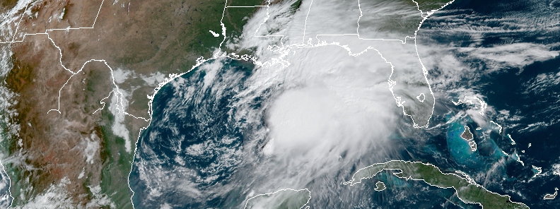
At 15:00 UTC (10:00 CDT) on October 18, 2019, its center was located 365 km (230 miles) SSW of the Mouth of Mississippi River and 635 km/h (395 miles) SW of Panama City, Florida.
Maximum sustained winds increased from 65 km/h at 12:00 UTC to 95 km/h (60 mph) at 15:00 UTC. The system had a minimum central pressure of 1 001 hPa and was heading NE at 35 km/h (22 mph).
A Tropical Storm Warning is in effect for:
- Mississippi/Alabama border to Yankeetown Florida
- Grand Isle Louisiana to the Mouth of the Pearl River
A Storm Surge Warning is in effect for:
- Indian Pass Florida to Clearwater Beach Florida

Potential Tropical Cyclone Sixteen at 15:00 UTC on October 18, 2019. Credit: NOAA/GOES-East
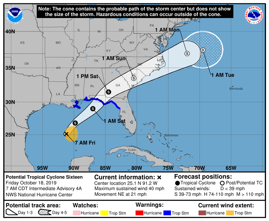
NE motion is expected to continue through Sunday, followed by a turn toward the ENE by early Monday. The system will approach the northern Gulf Coast later today and tonight and move inland across portions of the southeastern United States on Saturday and Sunday, October 19 and 20. It's forecast to move offshore of the coast of North Carolina by late Sunday (LT).
"The global models continue to indicate that the circulation will consolidate and the system will strengthen some during the next 12 hours or so, as the low-level circulation will be overtaken by an upper-level trough currently situated over southwest Louisiana.," NWS forecaster Brennan said.
"The system is still expected to become a tropical or subtropical storm later today, with the exact phase dependent on the timing of the circulation improving and the interaction with the upper trough. Once the system moves inland, it should become extratropical by 36 hours and slowly weaken once it moves offshore of the Carolinas by 72 – 96 hours before dissipating by day 5."
The combination of a dangerous storm surge and the tide will cause normally dry areas near the coast to be flooded by rising waters moving inland from the shoreline. The water could reach the following heights above ground somewhere in the indicated areas if the peak surge occurs at the time of high tide:
Indian Pass, FL to Chassahowitzka, FL: 90 – 150 cm (3 to 5 feet)
Chassahowitzka to Clearwater Beach, FL: 60 – 120 cm (2 to 4 feet)
Tampa Bay: 30 – 90 cm (1 to 3 feet)
Surge-related flooding depends on the relative timing of the surge and the tidal cycle, and can vary greatly over short distances.
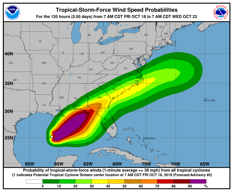
Tropical storm conditions are expected to reach the coast within the warning area by later today and this evening, making outside preparations difficult or dangerous.
Gale-force winds are likely along portions of the Atlantic coast of the southeastern United States by Saturday.
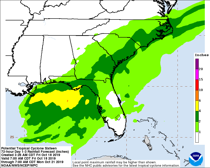
The disturbance is expected to produce total rainfall accumulations of 50 – 100 mm (2 to 4 inches) this weekend from the central Gulf Coast and northern and central Florida to the eastern Carolinas, with isolated maximum amounts of 150 mm (6 inches).
A tornado or two is possible tonight and early Saturday near the Florida Gulf Coast from the central panhandle to the western peninsula.
Featured image: Potential Tropical Cyclone Sixteen at 15:00 UTC on October 18, 2019. Credit: NOAA/GOES-East
Commenting rules and guidelines
We value the thoughts and opinions of our readers and welcome healthy discussions on our website. In order to maintain a respectful and positive community, we ask that all commenters follow these rules.