
Shallow M4.6 earthquake hits Seattle, Washington – the strongest since 2001
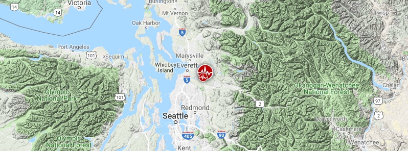
Image credit: USGS
A shallow earthquake registered by the USGS as M4.6 hit Three Lakes, Seattle, Washington at 09:51 UTC (03:51 LT) on July 12, 2019. The agency is reporting a depth of 22.3 km (13.8 miles).
This is the strongest earthquake to hit the region since M6.8 Nisqually on February 28, 2001; 18 years ago.
Date | Location | MMI | Mag. | Deaths | Injuries | Damage |
|---|---|---|---|---|---|---|
February 28, 2001 | Puget Sound | VIII | 6.8 Mw | 0–1 | 400 | $1–4 billion |
July 3, 1999 | Satsop | VII | 5.8 Mw |
| 7 | $8.1 million |
April 29, 1965 | Puget Sound | VIII | 6.7 Mw | 7 |
| $12.5 million |
November 6, 1962 | Clark County | VII | 5.2 Mw |
|
| Minor |
April 13, 1949 | Olympia | VIII | 6.7 Mw | 8 | At least 64 | $25 million |
June 23, 1946 | Strait of Georgia | VIII | 7.3 Mw | 2 |
| Limited |
April 29, 1945 | North Bend | VII | 5.5 Ms |
|
| Minor |
November 29, 1891 | Puget Sound | VI |
|
|
| Tsunami |
December 15, 1872 | North Cascades | VIII | 6.5–7.0 |
|
| scientific interest |
January 26, 1700 | Cascadia subduction zone |
| 8.7–9.2 Mw |
|
| Tsunami |
List of strong earthquakes in the state of Washington
The quake was followed by M3.5 at 09:53 UTC.
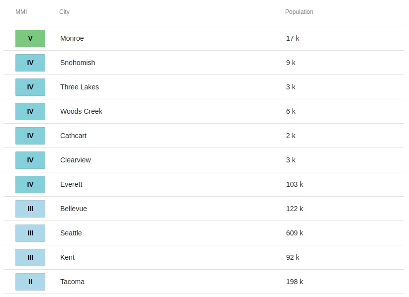
The epicenter was located 1.9 km (1.2 miles) SW of Monroe North (population 1 666), 3.3 km (2.1 miles) NW of Monroe (population 18 090), 10.9 km (6.7 miles) NE of Maltby (population 10 830) and 11.1 km (6.9 miles) E of Silver Firs (population 20 891), Washington, U.S.
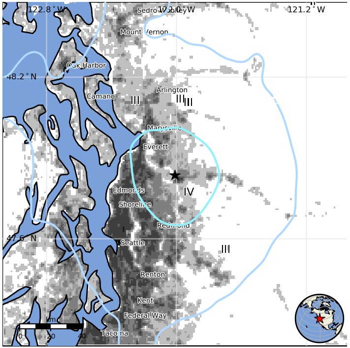
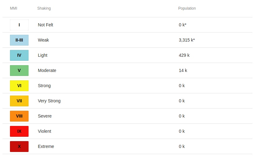
14 000 people are estimated to have felt moderate shaking 429 000 light and 3 315 000 weak.
More than 3 450 people reported feeling the quake over the next couple of hours.
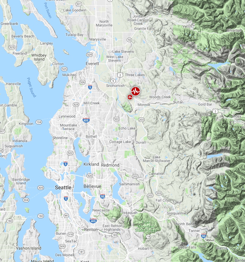
Image credit: Google, TW/SAM
There were no immediate reports of damage or casualties.
The USGS issued a green alert for shaking-related fatalities and economic losses.
Overall, the population in this region resides in structures that are resistant to earthquake shaking, though vulnerable structures exist. The predominant vulnerable building types are unreinforced brick masonry and reinforced masonry construction.
Recent earthquakes in this area have caused secondary hazards such as landslides and liquefaction that might have contributed to losses.
Estimated population exposure to earthquake shaking
Selected cities exposed
Regional seismicity
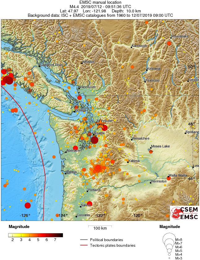
Earthquakes in the Pacific Northwest
Earthquakes in the Pacific Northwest (PacNW) states of Washington and Oregon result from slip on faults in a variety of geographic and geologic settings. Earthquakes in much of the region are a consequence of stresses associated with motion of the Juan de Fuca Oceanic Plate to the northeast with respect to the North America Continental Plate at a rate of several cm per year. This relative motion is largely made possible because the Juan de Fuca plate descends into the Earth's mantle below the North American continent along what is called the Cascadia Subduction Zone, which extends from northwestern California through western Oregon and western Washington to Vancouver Island, Canada. Relative plate motion that is not accommodated by subduction of the Juan de Fuca plate is accommodated by deformation of the overriding North America plate. Earthquakes are associated with both the subduction process and the deformation of the overriding North America plate.
Seismological terms that are commonly used to describe the different modes of earthquake occurrence in Washington, Oregon, and the offshore continental slope include the following:
- "Megathrust" earthquakes (also called "interplate" or "plate boundary" quakes in the context of subduction zone seismicity) result from rupture of the principal interface between the subducting Juan de Fuca plate and the overriding North America plate. The last great megathrust earthquake in the Cascadia subduction zone was in 1700, a 1000–km long rupture that is documented by studies of the resulting tsunami in Japan, by Native American oral traditions, and by geologic deposits from tsunami and offshore turbidity flows caused by the intense shaking and ground deformation associated with the earthquake. Most of the megathrust interface between the Juan de Fuca plate and the North American plate has not been seismically active in the decades during which it has been monitored by seismometers, except perhaps near Cape Mendocino (where a Gorda microplate is commonly demarcated within the broader Juan de Fuca plate) and at one location offshore from Astoria, Oregon. However, geodetic data show that compressive tectonic strain is currently accumulating across the Cascadia Megathrust as a result of the subduction process. Together with geologic evidence for the 1700 and earlier great earthquakes, the accumulation of compressive tectonic–strain implies that the recent quiescence of most of the Cascadia Subduction Zone Megathrust is temporary and that the ongoing subduction process will cause large and great earthquakes in the future.
- "Crustal" earthquakes originate from slip on faults within the crust of the North American Plate. Some of these earthquakes reflect stresses that are generated by the convergence of the Juan de Fuca and North America plates but most are related to stresses originating from the interaction of the North American plate and the Pacific plate in California and Nevada. This interaction results in north–south oriented compressive stresses in the crust throughout the western and northern region. These crustal earthquakes occur in the upper 25 km of the earth's crust on faults oriented roughly east–west and northwest–southeast. In southern Oregon, extensional (pull apart) stresses also cause faulting and crustal earthquakes. Many crustal fault zones have been mapped, including the Seattle Fault Zone, the South Whidbey Island Fault, the Devil's Mountain Fault, the Tacoma Fault in the Puget Sound lowlands, and the Spencer Canyon Fault in central Washington. However, not all of the active faults are mapped, and many crustal earthquakes occur on faults that don't reach the Earth's surface. The largest historically documented crustal earthquake was the 1872 M˜7 earthquake near Lake Chelan. Other crustal earthquakes have included the 1993 M5.6 Scott's Mills, Oregon, the 1993 M5.9 and M6.0 Klamath Falls, Oregon, and the 1996 M5.4 Duvall, Washington earthquakes.
- "Deep" earthquakes (also sometimes called "Benioff Zone" or "slab" earthquakes) result from faulting within the down–going Juan de Fuca Plate. These earthquakes are caused by stresses within the subducting plate beneath the plate interface and are due to the deformation of the plate during its slow descent into the earth's mantle beneath the North America plate. Because these earthquakes occur at depth within the descending slab, their causative faults are not visible, and the faults are not mapped or named. Examples of mantle earthquakes include the 2001 M6.8 Nisqually earthquake and very similar earthquakes in 1949 and 1965. These earthquakes occurred in the 45 km — 70 km depth range. These PacNW "deep" earthquakes are not that deep compared to those in a global context called "deep", a word often reserved for earthquakes occurring at depths greater than 300 km. Instrumentally recorded mantle earthquakes of the PacNW have had very few aftershocks.
- "Volcanic" earthquakes are located near volcanoes and are associated with volcanic processes. The category of volcanic earthquakes includes a variety of earthquake types. Seismograms of many volcanic earthquakes have characteristics that are very similar to those of non–volcanic crustal–earthquakes; these earthquakes are thought to result from the perturbation of the regional tectonic stress–field by the intrusion of magma and are denoted "volcano tectonic" earthquakes. Other volcanic earthquakes are characterized by signals that are much different than non–volcanic crustal–earthquakes and result from such processes as magmatic flow, bubbling and other processes within the liquid magma chamber, landslides caused by the shallow intrusion of lava, or the explosive violence of the eruption itself. During magmatic unrest at Mt. St. Helens in 1980 and 2004, hundreds of thousands of volcanic earthquakes took place.
- "Swarm" is a term used to describe the temporal distribution of events in a sequence of earthquakes, rather than a specific type or locale of earthquake. The term is used to denote a sequence of earthquakes in a small geographic area that are of similar size, in contrast to a "main–shock/aftershock sequence", in which a larger "main–shock", perhaps preceded by a few smaller foreshocks, is followed by a sequence of numerous smaller shocks that occur at a generally decreasing rate with time. The term "swarm" may be applied to sequences that last for hours to years, with the largest earthquake in the sequence commonly occurring after the sequence has begun. The term "swarm" may be used for sequences consisting of dozens of earthquakes as well as for sequences that consist of thousands of shocks. Volcanic unrest is typically associated with a swarm of volcanic earthquakes at or near a volcano.
I'm a dedicated researcher, journalist, and editor at The Watchers. With over 20 years of experience in the media industry, I specialize in hard science news, focusing on extreme weather, seismic and volcanic activity, space weather, and astronomy, including near-Earth objects and planetary defense strategies. You can reach me at teo /at/ watchers.news.
Commenting rules and guidelines
We value the thoughts and opinions of our readers and welcome healthy discussions on our website. In order to maintain a respectful and positive community, we ask that all commenters follow these rules.