
High-impact eruption at Anak Krakatau volcano, deadly tsunami produced, Indonesia
Powerful eruptions have been taking place at the Indonesian Krakatau volcano over the past 24 hours. The volcano is producing large lava flows and undersea landslides, believed to be the cause of at least one deadly tsunami.
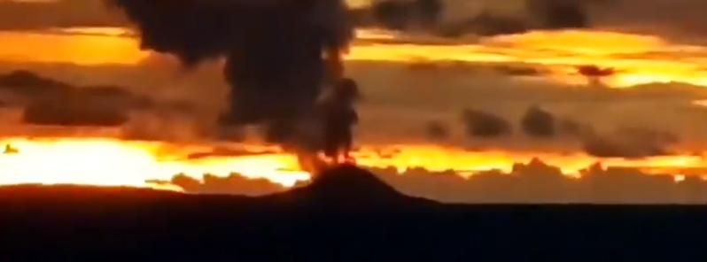
Featured image: Krakatau erupting on December 22, 2018. Credit: Sutopo Purwo Nugroho
According to the Darwin VAAC advisory issued 00:25 UTC, December 23, satellite imagery suggest a high-level eruption, with ash rising up to 16.7 km (55 000 feet) above sea level.
The Aviation Color Code was raised to Red.
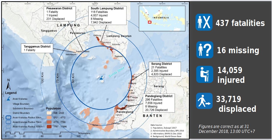
According to data provided by the country’s disaster management agency on December 31, at least 437 people have been killed, 14 059 were injured and 16 are still missing after a tsunami hit villages located around Sunda Strait. 33 719 people have been displaced.
At least 2 752 homes have been damaged, 69 hotels were severely damaged, 78 small commercial units and 510 boats and ships.
Officials said it is possible that the full moon may have contributed to the strength of the wave. According to locals, the tsunami hit around 21:30 LT, December 22 (14:30 UTC). One of the eyewitnesses told BBC that there had been heavy eruption sound prior to the tsunami.
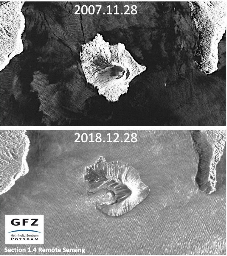
“The island of Anak Krakatau now has the shape of a 270 deg, almost closed crescent, with a water-filled crater in the center where once the 330 m (1,062 feet) tall summit cone stood,” volcanologist Tom Pfeiffer said on December 31.
“Processed satellite image acquired December 28 shows the change in morphology even clearer but includes a significant land gain after the collapse as well, which seems to have built most of the southern ‘arm’ of the crescent. Most of the new land is probably due to accumulated material (tephra) from the intense Surtseyan activity in the days after the landslide, building a new large tuff ring around the crater.”
Geological summary
The renowned volcano Krakatau (frequently misstated as Krakatoa) lies in the Sunda Strait between Java and Sumatra. The collapse of the ancestral Krakatau edifice, perhaps in 416 CE, formed a 7-km-wide (4.3 miles) caldera.
Remnants of this ancestral volcano are preserved in Verlaten and Lang Islands; subsequently Rakata, Danan and Perbuwatan volcanoes were formed, coalescing to create the pre-1883 Krakatau Island. Caldera collapse during the catastrophic 1883 eruption destroyed Danan and Perbuwatan volcanoes, and left only a remnant of Rakata volcano.
This eruption, the 2nd largest in Indonesia during historical time, caused more than 36 000 fatalities, most as a result of devastating tsunamis that swept the adjacent coastlines of Sumatra and Java. Pyroclastic surges traveled 40 km (25 miles) across the Sunda Strait and reached the Sumatra coast.
After a quiescence of less than a half century, the post-collapse cone of Anak Krakatau (Child of Krakatau) was constructed within the 1883 caldera at a point between the former cones of Danan and Perbuwatan. Anak Krakatau has been the site of frequent eruptions since 1927. (GVP)
I'm a dedicated researcher, journalist, and editor at The Watchers. With over 20 years of experience in the media industry, I specialize in hard science news, focusing on extreme weather, seismic and volcanic activity, space weather, and astronomy, including near-Earth objects and planetary defense strategies. You can reach me at teo /at/ watchers.news.
Great article as always. One comment really stood out. “Officials said it is possible that the full moon may have contributed to the strength of the wave” we all know the moon creates/helps our tidal movements. But never I have heard it as an excuse! the moon is closer! I took photos of the moon and I cannot remember in my 50 years a moon a( full one at that) so close? It looked odd especially with a red dawn in the Eastish? Direction (Well it does keep moving)keep looking to the skies guys
Quote: “The tsunami hit Indonesia.”
Today, when warming is destroying all countries – every country, or group of countries, must have a working environmentalist. A functioning environmentalist is able to prevent, or significantly mitigate, natural disasters that should strike the country.
I will not talk much about his work – I will say about the first stage. The first stage is cooling the territory of the country, its inland waters, and the surrounding seas to centuries-old norms. Term – 4 years.
Part of the chilled water will be fed into the forest – and protect them from fires by 95-97%. Saving forests, and planting the estimated number of tree seedlings, will allow the destruction of carbon dioxide and poisonous smog. Plus, other work.
Sincerely, environmental programs developer, Victor Rodin. Ukraine. Khmelnitsky NPP. Tel. Kiev Star: 961336344. Mail: [email protected], [email protected]
— — —
Цитата: «На Индонезию обрушилось цунами».
Сегодня, когда потепление разрушает все страны – каждая страна, или группа стран, должна иметь действующего эколога. Действующий эколог способен предотвращать, или значительно ослаблять стихийные бедствия, которые должны обрушиться на страну.
Я не буду много рассказывать о его работе – скажу о первом этапе. Первый этап – это охлаждение территорий страны, её внутренних вод, и окружающих морей до многовековых норм. Срок – 4 года.
Часть охлаждённой воды будут поданы в леса – и защитят их от пожаров на 95-97%. Сохранение лесов, и посадка расчётного количества саженцев деревьев, позволит уничтожить углекислый газ и ядовитый смог. Плюс, другие работы.
IT IS THE INCREASE OF COSMIC RAYS, MYTH MAKERS
The magnetic field of the Earth is under increasing stress, due to the increase of cosmic rays. This is the reason for the enormous increase in geological activity. And Cosmic rays will increase further in the time to come. Make no doubt about it. The Sun has not reached its highest position in the galaxy yet. As it moves higher in galaxy more and more galactic Cosmic rays will enter into the solar system. If one looks into solar activities in the last a few decades and the rate of Cosmic rays, one can see the picture very clearly.