
Significant earthquake swarm near the coast of Valparaiso, Chile
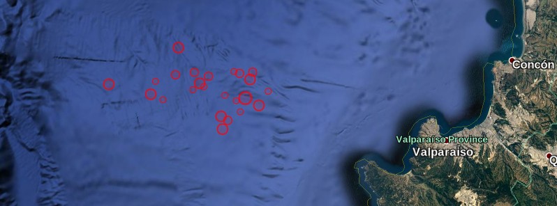
Image credit: USGS
A series of moderate to strong earthquakes were registered near the coast of Valparaiso, Chile on April 22 and 23, 2017. EMSC is reporting at least 25 earthquakes since 22:46 UTC on Saturday, April 22, 2017, with the strongest registered as M6.0 at a depth 20 km (12.4 miles). USGS is reporting this one as M5.9 at a depth of 9.8 km (5.6 miles).
The quakes are occurring some 30 km (18.6 miles) west of Valparaiso (population 283 000) and 130 km (80.7 miles) west of capital Santiago (population 4 838 00) at depths between 10 and 30 km (6.2 – 18.6 miles). There are about 1 337 405 people living within 100 km (62 miles).
.jpg)
ONEMI director, Ricardo Toro, said seven earthquakes were felt by population between the regions of Coquimbo and O'Higgins. The maximum perceived intensity was VI on Mercalli scale in the communes of Valparaíso, Puchuncaví, Casablanca, San Antonio and Villa Alemana, in the Valparaíso Region and in the commune of Tiltil, in the Metropolitan Region.
"According to information provided by the National Seismological Center, the strongest earthquake was 6.0 on the Richter scale, whose epicenter was 48 km (30 miles) west of Valparaiso," Toro said and added that tsunami from this one was not expected. "There were no reports of injuries or damage."
"We call on the population to remain calm, inform themselves through official channels and prioritize text messages or social networks to communicate, in addition to having their emergency kit ready in case of a major emergency," he said.
Ross Stein and Volkan Sevilgen of Temblor said the quakes are occurring on or near the megathrust surface 30 km (18 miles) offshore the major port city of Valparaiso.
"Sustained sequences of moderate shocks are rare; most instead begin with the largest shock, termed the ‘mainshock,’ followed by ‘aftershocks’ that become less frequent with time, and are only rarely larger than the mainshock. So, in both respects – magnitude and frequency – this sequence looks different. Staccato seismic swarms like this one probably accompany slow slip on either the megathrust, or a thrust fault that splays off the megathrust. The depth and location of the sequence, as well as the ‘focal mechanism’ of the largest shock, suggest that the sequence is occurring on, or more likely above, the megathrust surface, where the Nazca Plate is descending beneath the South American Plate," they explained.
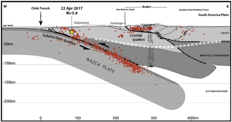
Subduction of the Nazca plate beneath the deformed and faulted South American plate, from Armijo et al. (2010). Santiago lies at the foot of the Andes. The red dots show the best-located M≥4.0 earthquakes during the period, 2000–2005, by Servicio Sismológico Nacional of Universidad de Chile. Credit: Temblor
"The world’s great quakes have all struck on megathrusts, and the largest quake ever recorded – a M9.5 event in 1960 – struck along the Chile Trench in 1960 about 800 km (500 miles) to the south of today’s events. Closer to home was the 2010 M8.8 Maule, Chile, earthquake, which we calculate brought the Valparaiso portion of the megathrust closer to failure. That earthquakes should occur in this location is consistent with the Coulomb stress transfer from the 2010 M8.8 Maule shock. One can see on the image below that the megathrust surface offshore Valparaiso was brought closer to failure (turns orange), whereas the stress dropped on the part of the megathrust that slipped in the 2010 shock (turns blue)."
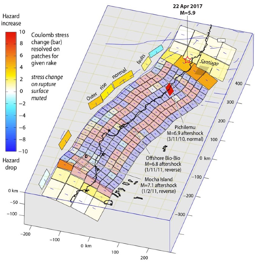
Coulomb stress imparted by the 2010 M=8.8 Maule, Chile, earthquake to the surrounding faults. We calculate the stress was increased at the site of today’s swarm. Credit: Temblor
Update:
A powerful M7.1 earthquake hit the region at 21:38 UTC on April 24. USGS is reporting a depth of 10 km (6.2 miles). CSN Chile is reporting a preliminary magnitude of M6.7, 25 km (15.5 miles) west of Valparaiso.
Seismotectonics of South America (Nazca plate region)
The South American arc extends over 7,000 km, from the Chilean margin triple junction offshore of southern Chile to its intersection with the Panama fracture zone, offshore of the southern coast of Panama in Central America. It marks the plate boundary between the subducting Nazca plate and the South America plate, where the oceanic crust and lithosphere of the Nazca plate begin their descent into the mantle beneath South America. The convergence associated with this subduction process is responsible for the uplift of the Andes Mountains, and for the active volcanic chain present along much of this deformation front. Relative to a fixed South America plate, the Nazca plate moves slightly north of eastwards at a rate varying from approximately 80 mm/yr in the south to approximately 65 mm/yr in the north. Although the rate of subduction varies little along the entire arc, there are complex changes in the geologic processes along the subduction zone that dramatically influence volcanic activity, crustal deformation, earthquake generation and occurrence all along the western edge of South America.
Most of the large earthquakes in South America are constrained to shallow depths of 0 to 70 km resulting from both crustal and interplate deformation. Crustal earthquakes result from deformation and mountain building in the overriding South America plate and generate earthquakes as deep as approximately 50 km. Interplate earthquakes occur due to slip along the dipping interface between the Nazca and the South American plates. Interplate earthquakes in this region are frequent and often large, and occur between the depths of approximately 10 and 60 km. Since 1900, numerous magnitude 8 or larger earthquakes have occurred on this subduction zone interface that were followed by devastating tsunamis, including the 1960 M9.5 earthquake in southern Chile, the largest instrumentally recorded earthquake in the world. Other notable shallow tsunami-generating earthquakes include the 1906 M8.5 earthquake near Esmeraldas, Ecuador, the 1922 M8.5 earthquake near Coquimbo, Chile, the 2001 M8.4 Arequipa, Peru earthquake, the 2007 M8.0 earthquake near Pisco, Peru, and the 2010 M8.8 Maule, Chile earthquake located just north of the 1960 event.
Large intermediate-depth earthquakes (those occurring between depths of approximately 70 and 300 km) are relatively limited in size and spatial extent in South America, and occur within the Nazca plate as a result of internal deformation within the subducting plate. These earthquakes generally cluster beneath northern Chile and southwestern Bolivia, and to a lesser extent beneath northern Peru and southern Ecuador, with depths between 110 and 130 km. Most of these earthquakes occur adjacent to the bend in the coastline between Peru and Chile. The most recent large intermediate-depth earthquake in this region was the 2005 M7.8 Tarapaca, Chile earthquake.
Earthquakes can also be generated to depths greater than 600 km as a result of continued internal deformation of the subducting Nazca plate. Deep-focus earthquakes in South America are not observed from a depth range of approximately 300 to 500 km. Instead, deep earthquakes in this region occur at depths of 500 to 650 km and are concentrated into two zones: one that runs beneath the Peru-Brazil border and another that extends from central Bolivia to central Argentina. These earthquakes generally do not exhibit large magnitudes. An exception to this was the 1994 Bolivian earthquake in northwestern Bolivia. This M8.2 earthquake occurred at a depth of 631 km, which was until recently the largest deep-focus earthquake instrumentally recorded (superseded in May 2013 by a M8.3 earthquake 610 km beneath the Sea of Okhotsk, Russia), and was felt widely throughout South and North America.
Subduction of the Nazca plate is geometrically complex and impacts the geology and seismicity of the western edge of South America. The intermediate-depth regions of the subducting Nazca plate can be segmented into five sections based on their angle of subduction beneath the South America plate. Three segments are characterized by steeply dipping subduction; the other two by near-horizontal subduction. The Nazca plate beneath northern Ecuador, southern Peru to northern Chile, and southern Chile descend into the mantle at angles of 25° to 30°. In contrast, the slab beneath southern Ecuador to central Peru, and under central Chile, is subducting at a shallow angle of approximately 10° or less. In these regions of “flat-slab” subduction, the Nazca plate moves horizontally for several hundred kilometers before continuing its descent into the mantle, and is shadowed by an extended zone of crustal seismicity in the overlying South America plate. Although the South America plate exhibits a chain of active volcanism resulting from the subduction and partial melting of the Nazca oceanic lithosphere along most of the arc, these regions of inferred shallow subduction correlate with an absence of volcanic activity. (USGS) More information on regional seismicity and tectonics
I'm a dedicated researcher, journalist, and editor at The Watchers. With over 20 years of experience in the media industry, I specialize in hard science news, focusing on extreme weather, seismic and volcanic activity, space weather, and astronomy, including near-Earth objects and planetary defense strategies. You can reach me at teo /at/ watchers.news.
Commenting rules and guidelines
We value the thoughts and opinions of our readers and welcome healthy discussions on our website. In order to maintain a respectful and positive community, we ask that all commenters follow these rules.