
Explosive eruption at Bogoslof volcano, Alaska
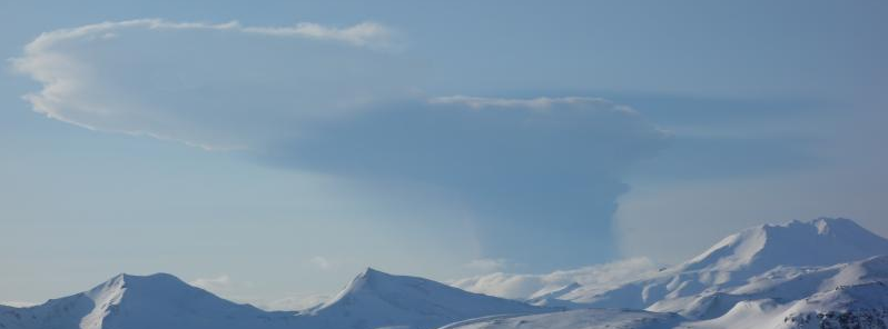
Featured image: Bogoslof eruption plume as seen from Unalaska Island, 85 km (53 miles) ESE of the crater. Photo taken from helicopter during fieldwork by AVO geologists at 04:22 UTC, approximately 14 minutes after the start of the eruption. Credit: Janet Schaefer, AVO/ADGGS
A significant explosive eruption began at Bogoslof stratovolcano at 02:08 UTC on February 20, 2017, and lasted about 37 minutes. Satellite images following the activity showed a volcanic plume extending about 160 km (100 miles) to the southeast over Unalaska Island and the Pacific Ocean.
Seismic and infrasound data show a series of short-lived explosive pulses through 02:45 UTC, but seismicity has been quiet since then.
Recent satellite images show a cloud as high as 7.6 km (25 000 feet) above sea level. Thus, AVO has raised the Aviation Color Code to RED and Alert level to WARNING.
Winds are carrying the cloud from Bogoslof to the southeast, towards Unalaska Island.
Satellite images following the activity showed a volcanic plume extending about 160 km (100 miles) to the southeast over Unalaska Island and the Pacific Ocean.
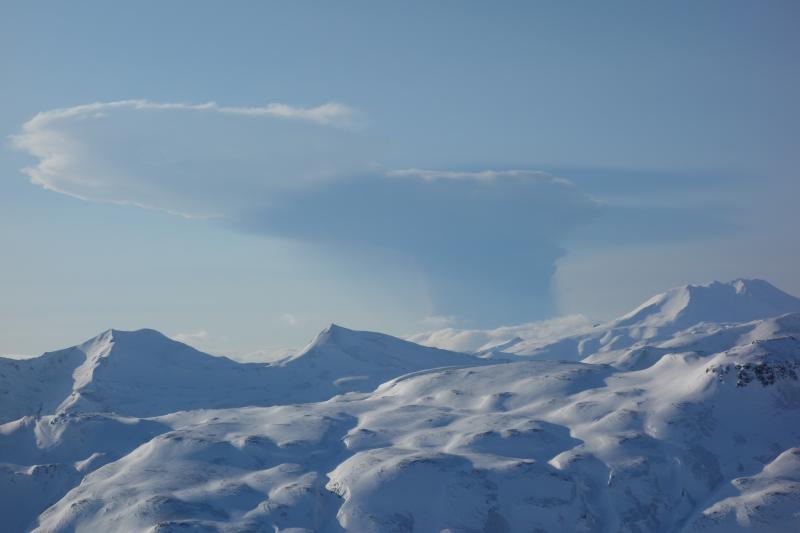
The plume was visible in images through 04:00 UTC. AVO geologists on Unalaska Island described the cloud as having a white upper portion and a slightly darker lower portion.
Bogoslof remains at a heightened state of unrest and in an unpredictable condition. Additional explosions producing high-altitude volcanic clouds could occur at any time.
Low-level explosive activity that is below AVO's ability to detect in data sources may be occurring. These low-level explosions could pose a hazard in the immediate vicinity of the volcano.
Bogoslof eruption plume as seen from Unalaska Island, 85 km (53 miles) ESE of the crater. Photo taken from helicopter during fieldwork by AVO geologists at 04:22 UTC, approximately 14 minutes after the start of the eruption. Credit: Janet Schaefer, AVO/ADGGS
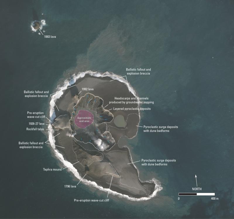
Features and deposits on Bogoslof Island after the eruptive events of January 30 – 31, 2017. Shallow groundwater flow through the new volcanic deposits from the sea toward the center depression has resulted in the formation of concentric headscarps and channels. This process, called sapping, is common in areas of concentrated groundwater discharge where it undermines slopes and leads to headward erosion and the formation of arcuate headscarps. Rubbly appearing rock debris scattered over parts of the island was likely generated by near surface explosions of a still submarine lava plug, showering the island with blocks and bombs of rock debris. Some of these rock fragments are up to 2.5 m (8.2 feet) in length. The mound of tephra on the southern part of the island is a tuff cone, and the level area making up the northern half of the island is a tuff ring. These are characteristic landforms of shallow submarine eruptions. The Bogoslof Island landscape is susceptible to rapid erosion, primarily by ocean waves, and erosion of the surficial volcanic deposits will be ongoing and changes in the configuration of the island are likely. ©2017 Digital Globe. Base image Worldview-3, January 31, 2017. Credit: Chris Waythomas, AVO/USGS
Geological summary
Bogoslof is the emergent summit of a submarine volcano that lies 40 km north of the main Aleutian arc. It rises 1500 m above the Bering Sea floor. Repeated construction and destruction of lava domes at different locations during historical time has greatly modified the appearance of this "Jack-in-the-Box" volcano and has introduced a confusing nomenclature applied during frequent visits of exploring expeditions.
The present triangular-shaped, 0.75 x 2 km island consists of remnants of lava domes emplaced from 1796 to 1992. Castle Rock (Old Bogoslof) is a steep-sided pinnacle that is a remnant of a spine from the 1796 eruption. Fire Island (New Bogoslof), a small island located about 600 m NW of Bogoslof Island, is a remnant of a lava dome that was formed in 1883. (GVP)
The Watchers team and our contributors bring the latest on extreme weather, earthquakes, volcanic eruptions, space weather, and all things science. We're all about making sense of the natural world and keeping you informed on what’s happening. Got a tip or a question? Hit us up using the form at newstips!
Commenting rules and guidelines
We value the thoughts and opinions of our readers and welcome healthy discussions on our website. In order to maintain a respectful and positive community, we ask that all commenters follow these rules.