
Nigeria on red flooding alert, more than 5 000 homes already destroyed in Kano
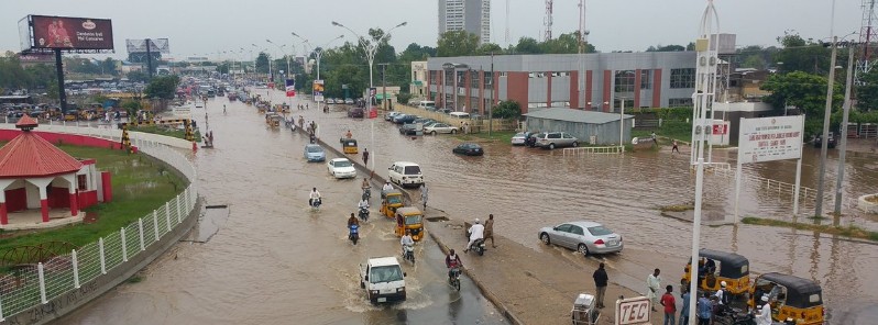
Featured image: Kano flooded on August 4, 2016. Credit: Sanusi Dantata
Nigerian authorities have warned residents of 11 states for imminent flooding after several rivers started overflowing on August 8, 2016. Although no specific dates were given, the warnings will remain in place through October and flooding is already very serious in several states. Authorities are urging residents to pay attention to warnings, reminding them of disastrous, widespread flooding in 2012 that killed 363 and displaced over 2.1 million people by November 5. The flooding in 2012 was termed as the worst in 40 years. It affected 36 Nigeria's states, an estimated total of seven million people.
According to Nigeria Meteorological Agency (NiMet), intense rainfall over the last two months has saturated the grounds, across parts of the country, including Akwa Ibom, Bauchi, Benue, Borno, Cross River, Delta, Kaduna, Nasarawa, Yobe, and Zamfara. The agency warned the soil is no longer capable of absorbing rainfall over the next few weeks, coinciding with the peak of the rain season.
The flood alert issued by the Nigerian Hydrological Service Agency (NHSA) is a timely warning that should not be ignored but heeded to avert disaster. All Africa reports:
"Although, NHSA did not give the actual dates of the floods, from experience, flooding in Nigeria occurs at the peak of the rainy season in June and in September. With the first peak over, the next peak is September after the August break during which the NHSA predicts an overflow of the Niger-Benue River basins and other sub-basins, with fears of flooding in the adjoining states.
States at risk include Niger, Benue, Sokoto, Anambra, Imo, Cross River, Yobe, Ogun, Kebbi, Osun, Zamfara, Katsina, Kwara, Adamawa, Bauchi, Borno, Gombe, Taraba, Kogi, Plateau and Nasarawa. Others are Rivers, Edo, Bayelsa, Delta, Enugu, Lagos, Ondo, Akwa Ibom, Ebonyi, Abia, Jigawa and Kano.
With 33 states listed, virtually, the entire country is, therefore, at risk."
The hydrological service said various banks of River Niger, River Benue, Kainji Dam and the Confluence of water bodies in Lokoja overflowed on Monday, August 8, 2016.
Heavy rains in Kano over the past couple of days have destroyed at least 5 300 houses across the districts of Bebeji, Dawakin Kudu, Kiru Shanono, Bagwai, and Garun Mallam. The full damage extent is still unknown, and damage assessments are being carried out at present.
So pissed by what I saw in #kano today! Flooding everywhere. Govt doesn't seem to care while the masses keep quite! pic.twitter.com/v7qaQ9sWP4
— Sanusi Dantata (@SasDantata) August 5, 2016
This is zungeru road, #Kano. Yday. pic.twitter.com/3rvGvtLGHI
— Architect Dr King (@mustysarina) August 6, 2016
Three people were reported dead in Bebeji, Kano last week, according to the News Agency of Nigeria (NAN).
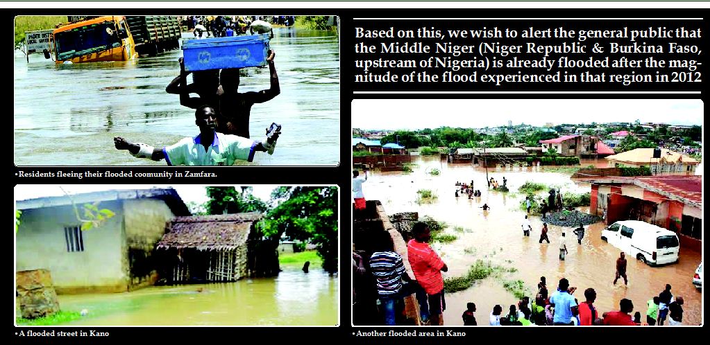
Image courtesy The Nation
The government, communities, and residents have been advised to take precaution measures, such as avoiding activities that block the free flow of flood waters, and cleaning water channels and drainages.
NEMA has advised those residing along the River Niger to move to safer grounds, as river levels are expected to rise: “Following intense rainfall and rises in water level, the National Emergency Management Agency has advised communities along the river Niger to evacuate immediately to safer ground over the likelihood of floods that may occur at any moment from now."
“Niger Basin Authority (NBA) notified Nigeria that rainy season, which started in the Middle Niger (Burkina Faso and the Niger Republic) in June 2016, has led to a gradual rise of the level of River Niger in Niamey, Niger Republic. This high level of water in the Niger Republic is already spreading to the Benin Republic, and invariably, to Nigeria," stated Muhammad Sani Sidi, the Director General of NEMA.
According to Mr. Sani Sidi, the level of water in all the hydrological monitoring stations across the state have exceeded the corresponding values by August 5, a situation that requires immediate action. The water levels can be compared to a disastrous widespread flooding event of 2012.
The most sensitive spots along the river Niger and its Benue belts have been identified, and the authorities have urged the state to utilize the flood vulnerability maps provided by NEMA to find safer grounds, capable of providing temporary shelters during evacuations.
Flash floods are expected to also occur in some urban centers like Lagos, Port Harcourt, Sokoto, Ibadan, Kaduna, Yola, Maiduguri, Makurdi and Hadejia due to poor drainage system. The predicted probable flood area this year would be higher than the previous year.
NHSA added that although there was presently no water releases from the Lagdo Dam in Cameroon, the heavy rainfall being witnessed within the catchment of River Benue had caused the water level to be on the increase. It stated that on August 8, 2016, its monitoring station at Makurdi recorded an alarming 9.20 m (30.2 feet) height in water level, as against 9.17 m (30.08 feet) recorded on August 8, 2012.
“At the Confluence in Lokoja, the water level on August 8 was at 7.74 m (25.39 feet), which has exceeded the 7.72 m (25.32 feet) recorded value on August 8, 2012. This value is sending a strong signal to dwellers within the flood plains to relocate immediately to safer and higher grounds.
Downstream of Lokoja at Onitsha, the water level has risen to an alarming height of 9.16 m (30.05 feet) and this value is expected to increase with time. Therefore, residents along the Habour Bridge Head and industrial activities within the Habour Industrial Layout, Onitsha, should be on the lookout.”
A combination of heavy downpour, ocean surge or the release of water from the Lagdo Dam in northern Cameroun floods Nigeria each year. The problem climaxed in 2012 when all the states bestriding the river Niger-Benue, down to the Niger Delta, were submerged with huge loss of lives and property.
Commenting rules and guidelines
We value the thoughts and opinions of our readers and welcome healthy discussions on our website. In order to maintain a respectful and positive community, we ask that all commenters follow these rules.