
Lake Mead reaches record low for the second year in a row, US
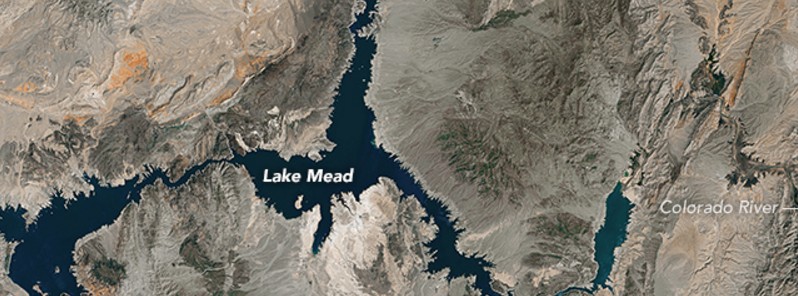
Image credit: USGS/NASA Landsat-8
The surface level of Lake Mead at the Hoover Dam stood at 327.36 m (1 074.03 feet) above sea level on May 25, 2016. The last time it was this low was in 1937, when water managers were still filling the reservoir and putting finishing touches on the Hoover Dam. The lake is now 37% full and it last approached full capacity in the summer of 1983.
According to data from the U.S. Bureau of Reclamation, the water level has now reached a record low for the second year in a row. The previous low of 327.68 m (1 075.08 feet) was set in late June 2015.
The lowest water levels each year are usually reached in late June or July, after water managers have released the yearly allotment of water for farmers and cities farther down the Colorado River watershed. That means water levels are likely to continue to fall in 2016 to roughly 326 m (1 070 feet), according to the Bureau of Reclamation.
Landsat images below show the lake near its highest and lowest points over the past 32 years. The top image was acquired on May 15, 1984, by the Thematic Mapper on the Landsat 5 satellite. The second image was acquired on May 23, 2016, by the Operational Land Imager (OLI) on Landsat 8. Notice the white-tan “bathtub ring” around the edges of the water; this is exposed sand and minerals that would normally be under water.
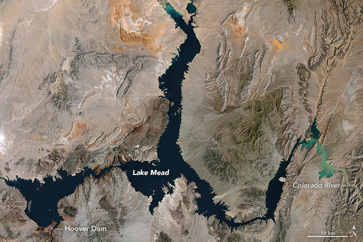
Landsat-5 image acquired May 15, 1984
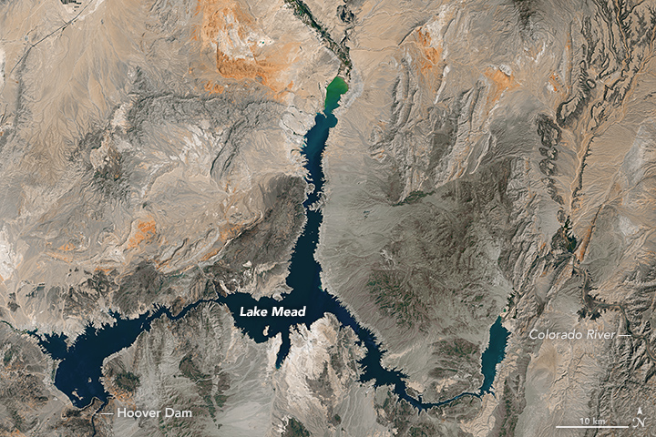
Landsat-8 image acquired May 23, 2016
At maximum capacity, the reservoir would hold 36 trillion liters (9.3 trillion gallons) of water, reaching an elevation 372 m (1 220 feet) near the dam. Most of the water in this great reservoir comes from snowmelt in the Rocky Mountain range and travels through Lake Powell, the Grand Canyon, and into Lake Mead. Farmers and some cities in Arizona, Nevada, California, and northern Mexico all rely on water from Lake Mead.
According to the Bureau of Reclamation, the lake will be refilled enough by the end of 2016 to avoid cuts in water deliveries in 2017. Despite the ongoing drought, Lake Mead National Recreation Area continues to operate water sports, sightseeing and hiking facilities in the area.
The Colorado Basin has endured roughly sixteen years of drought and declining water levels in Lake Mead and Lake Powell. At the same time, the population in this sun-drenched region continues to grow.
Source: EO
The Watchers team and our contributors bring the latest on extreme weather, earthquakes, volcanic eruptions, space weather, and all things science. We're all about making sense of the natural world and keeping you informed on what’s happening. Got a tip or a question? Hit us up using the form at newstips!
Commenting rules and guidelines
We value the thoughts and opinions of our readers and welcome healthy discussions on our website. In order to maintain a respectful and positive community, we ask that all commenters follow these rules.