
Intense thermal anomaly over Alaid volcano, Russia
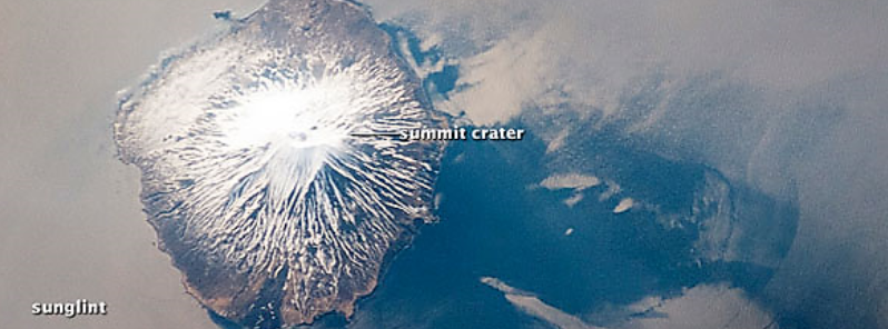
Featured image: Photograph of Alaid during clear viewing conditions taken by the International Space Station's Expedition 31 crew on May 18, 2012. The silver-gray appearance on the sea surface surrounding much of the volcano results from strongly reflected sunlight bounced off the sea surface (sunglint). The image was provided by the ISS Crew Earth Observations experiment and Image Science & Analysis Laboratory, Johnson Space Center (Photo ID, ISS031-E-41959). Image credit: The International Space Station, The Image Science & Analysis Laboratory at Johnson Space Center, and William L. Stefanov (Jacobs/ESCG at NASA-JSC)
An intense thermal anomaly was observed over Alaid volcano in Northern Kuriles, Russia on February 20 and 21, 2016, Kamchatka Volcanic Eruption Response Team (KVERT) reports.
A thermal anomaly was detected at 20:00 UTC on February 20 and at 00:56 UTC on February 21. According to satellite information, a weak ash emission extended about 50 km (31 miles) to the east of the volcano.

The weak eruptive activity of the Alaid volcano continues, according to KVERT. Ash explosions up to 6 km (19 700 feet) above the sea level, could occur at any time, and the ongoing activity could affect international and low-flying aircraft. The Aviation Color Code was raised to Yellow, accordingly.
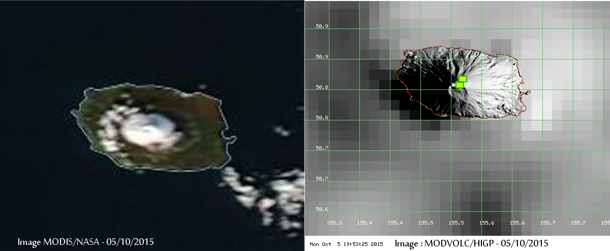
A new eruptive phase possibly started at the volcano during late September 2015. Tokyo VAAC reported elevated seismic activity and a possible plume that could rise to 6 km (18 000 feet) altitude (although not observed on satellite imagery) from the volcano on September 28. Satellite data showed thermal signals since October 1, suggesting a strong heat source in the summit crater, possibly caused by a Strombolian-type eruption.
According to GVP, moderate activity reported by KVERT, continued in the period between October 2 and 9. A thermal anomaly was detected daily over the volcano and the Aviation Color Code remained yellow throughout the period.
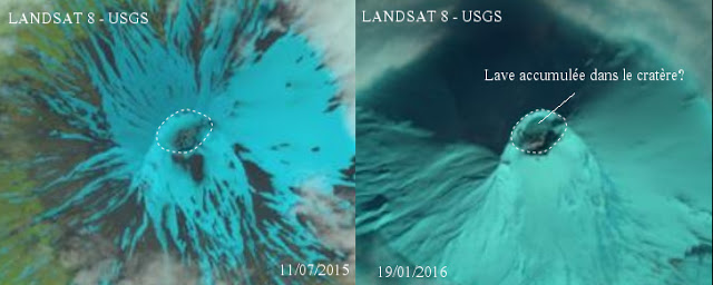
The eruption that began in October 2015 was over in January 2016. No more heat emission from the volcano has been observed until now, and visible satellite imagery showed that the crater has been partially filled with fresh lava from the eruption.
It cannot be determined yet if a new eruption is underway at the volcano, which is on of the most active ones in the area, although rarely visited.
Alaid’s most recent eruption which ended in January 2016 produced spectacular lava flows that flowed into the sea and enlarged the uninhabited island, Volcano Discovery reported.
Geological summary
The highest and northernmost volcano of the Kuril Islands, 2 285 m (7 496.7 feet) high Alaid is a symmetrical stratovolcano when viewed from the north, but has a 1.5 km (4 921.3 feet) wide summit crater that is breached widely to the south.
Alaid is the northernmost of a chain of volcanoes constructed west of the main Kuril archipelago and rises 3 000 m (9 842.5 feet) from the floor of the Sea of Okhotsk.
Numerous pyroclastic cones dot the lower flanks of basaltic to basaltic-andesite Alaid volcano, particularly on the NW and SE sides, including an offshore cone formed during the 1933-34 eruption. Strong explosive eruptions have occurred from the summit crater beginning in the 18th century.
Reports of eruptions in 1770, 1789, 1821, 1829, 1843, 1848, and 1858 were considered incorrect by Gorshkov (1970).
Explosive eruptions in 1790 and 1981 were among the largest in the Kuril Islands during historical time. (GVP)
It is interesting to observe: The sun rose in the west here this morning. Something I haven’t noticed to happen in decades. There is most definitely some anomaly going on.
please start writing to and influencing your politicians.
A vast expanse of permafrost in Siberia and Alaska has started to thaw for the first time since it formed 11,000 years ago, marked in dark blue on the map. It is caused by the recent 3+°C rise in local temperature over the past 40 years – more than four times the global average. Peat bogs cover an area of a million square miles (or almost a quarter of the earth’s land surface) to a depth of 25 meters. Those in Siberia are the world’s largest.
http://www.planetextinction.com/planet_extinction_permafrost.htm
https://www.researchgate.net/publication/226567411_Formation_of_a_third_volcanic_chain_in_Kamchatka_generation_of_unusual_subduction-related_magmas
https://www.google.co.uk/?gws_rd=ssl#q=siberia+permafrost+melt+massive+methane+release
Something I think many of you may be overlooking is the fact that the Suns position moves throughout the year. I’m not saying I disagree that the earths axis is shifting, only that movements of the Suns position noticed over a period of weeks or months is nothing more than earth rotating around it.
I noticed this morning 23/2/2016 the sun shone directly thru my bathroom window and wondered if the earth had moved off its axis so googled the question and was not surprised with what came up as over the years noticed changes very slowly but its been much faster in the past 4 weeks . Its all so interesting and in my opinion its already too late to change our ways. Greed is a big part of this problem.