
Odile crashes into Mexico as a powerful Category 3 hurricane
Featured image: Hurricane "Odile" on September 15 infrared/visible. Image credit: CIMSS
Hurricane "Odile" crashed into Mexico's Los Cabos resorts on Monday, September 15, 2014, forcing about 30 000 people to seek shelters. It is the strongest hurricane to make landfall this year anywhere and the strongest on record to hit Baja California.
Odile was a Category 3 hurricane on the five-level Saffir-Simpson Hurricane Wind scale packing winds of 205 km/h (125 mph) when it made landfall near Cabo San Lucas. Forecasters warn that heavy rains of up to 46 centimeters (18 inches) in some areas could produce life-threatening floods and mudslides.
National Civil Protection coordinator Luis Felipe Puente said the storm took down trees, power lines and roof tiles as it crashed.
Some 26 000 foreign tourists and another 4 000 Mexicans were staying in 18 hotels converted into temporary shelters. Power in Cabo San Lucas is cut off to prevent electrocutions.
Schools are closed on Monday and independence day festivities are called off.
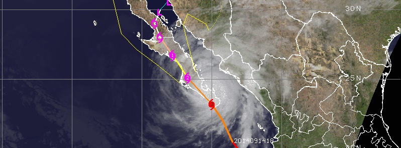
Odile is a large hurricane, hurricane-force winds extend outward up to 85 km (50 miles) from the center. Tropical-storm-force winds extend outward out to 295 km (185 miles).
It's center will move near or over the Baja California through Tuesday.
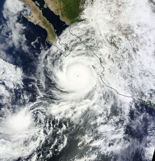
Hurricane "Odile" on September 14, 2014. Image credit: NASA Terra/MODIS
Turismo y población en Los Cabos sin la protección ofertada por @osoriochong y su presidente incompetente @EPN pic.twitter.com/YUvsbBL55f
— Fernando Alférez (@Alferez_Ags) September 15, 2014
Maximum alert in Mexico as Hurricane #Odile set to strike Baja California within hours pic.twitter.com/lS1jTxXSgh
— BBC News (World) (@BBCWorld) September 14, 2014
This is happening: We are waiting for #Odile to hit Los Cabos soon. It's going to be a looong night. pic.twitter.com/fKtOdL3q8s
— Alba Mora Roca (@albamoraroca) September 15, 2014
More #Odile damage photos coming out of the Cabo San Lucas area, via @Aldolr – pic.twitter.com/VJQLz4Q2sS
— Jacob Wycoff (@4cast4you) September 15, 2014
At 10:00 UTC today, Odile was located approximately 19 nautical miles (35 km/21 miles) north-northwest of Cabo San Lucas moving north-northwestward at 14 knots (16 mph/25 km/h). Maximum sustained winds were near 175 km/h (110 mph) making Odile a Category 2 hurricane. Estimated minimum central pressure was 945 mb.
Steady weakening is forecast during the next 48 hours.
According to NHC, hurricane conditions will continue to spread northward over Baja California Sur within the Baja California Sur from Punta Abreojos to Santa Rosalia through tonight. Tropical storm conditions will continue to spread northward across the Baja California peninsula in advance of the hurricane conditions. A dangerous storm surge is expected to produce significant coastal flooding in areas of onshore winds. Near the coast the surge will be accompanied by large and destructive waves.
Odile is expected to produce rainfall amounts of 15 – 30 cm (6 to 12 inches) with isolated maximum totals of around 45 cm (18 inches) across much of the Baja California peninsula through Friday. These rains are likely to result in life-threatening flash floods and mud slides. Rainfall amounts of 5 – 10 cm (2 to 4 inches) are possible along coastal portions of the Mexican states of Sinaloa and Sonora.
Swells from Odile will affect portions of the southwestern coast of Mexico during the next couple of days and are affecting southern portions of the Baja California peninsula and the southern Gulf of California. These swells will likely cause life-threatening surf and rip current conditions.
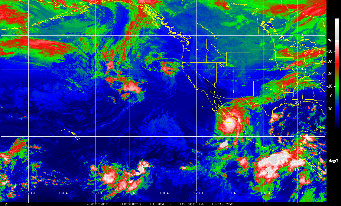
Hurricane "Odile" on September 15, 2014, at 11:45 UTC. Image credit: CIMSS
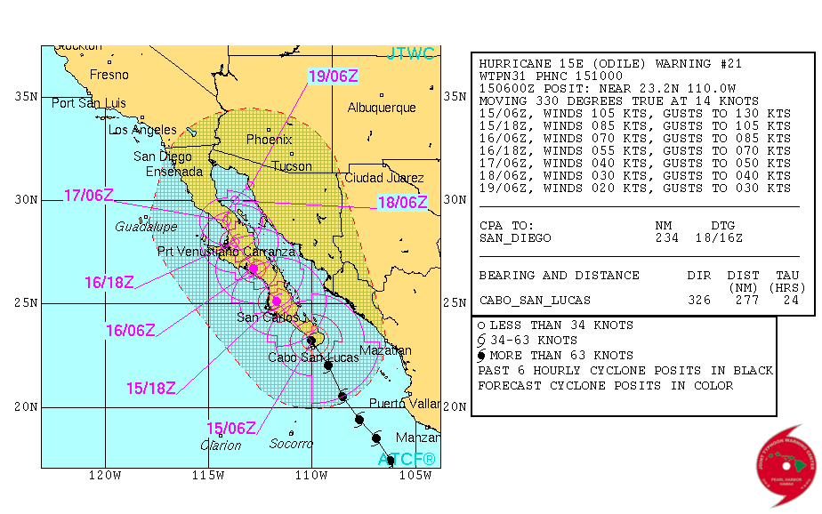
Hurricane "Odile" forecast track on September 15, 2014. Image credit: JTWC
Summary of watches and warnings in effect
A hurricane warning is in effect for:
* Baja California Sur from Punta Abreojos to Santa Rosalia
A hurricane watch is in effect for:
* the west coast of Baja California Sur from north of Punta Abreojos to Punta Eugenia.
A tropical storm warning is in effect for:
* the east coast of the Baja peninsula from north of Santa Rosalia to Bahia de los Angeles
* the west coast of the Baja peninsula from north of Punta Eugenia to San Jose de las Palomas
* mainland mexico from altata to bahia kinoA tropical storm watch is in effect for:
* the west coast of the Baja peninsula north of San Jose de las Palomas to Cabo San Quintin
* the east coast of the Baja peninsula from north of Bahia de los Angeles to San Felipe
* mainland Mexico from north of Bahia Kino to Puerto Libertad(NHC, Monday, September 15, 2014 @ 10:00 UTC)
Satellite animations:
- Storm-Centered Infrared (GOES 15; NOAA/SSD)
- Storm-Centered Infrared (Aviation Color Enhancement) (GOES 15; NOAA/SSD)
- Storm-Centered Water Vapor (GOES 15; NOAA/SSD)
- Storm-Centered Visible (GOES 15; NOAA/SSD)
- Storm-Centered Visible (Colorized) (GOES 15; NOAA/SSD)
- Storm-Centered Infrared (GOES 15; CIMSS)
- Storm-Centered Enhanced Infrared (GOES 15; CIMSS)
- Storm-Centered Water Vapor (GOES 15; CIMSS)
- Storm-Centered Visible (GOES 15; CIMSS)
- East Pacific Infrared (GOES 15; NOAA/SSD)
- East Pacific (Aviation Color Enhancement) (GOES 15; NOAA/SSD)
- East Pacific Water Vapor (GOES 15; NOAA/SSD)
- East Pacific Visible (GOES 15; NOAA/SSD)
- East Pacific Visible (Colorized) (GOES 15; NOAA/SSD)
I'm a dedicated researcher, journalist, and editor at The Watchers. With over 20 years of experience in the media industry, I specialize in hard science news, focusing on extreme weather, seismic and volcanic activity, space weather, and astronomy, including near-Earth objects and planetary defense strategies. You can reach me at teo /at/ watchers.news.
Commenting rules and guidelines
We value the thoughts and opinions of our readers and welcome healthy discussions on our website. In order to maintain a respectful and positive community, we ask that all commenters follow these rules.