
Active volcanoes in the world: July 10 – July 16, 2013
Image credit: TW
This week, 6 volcanoes had new activity, ongoing activity was reported for 12 volcanoes. This report covers active volcanoes in the world recorded from July 10 – July 16, 2013 based on Smithsonian/USGS criteria.
New activity/unrest: | Kelimutu, Lesser Sunda Islands | Popocatépetl, México | Shiveluch, Kamchatka Peninsula | Tungurahua, Ecuador | Ubinas, Perú | Ulawun, New Britain
Ongoing activity: | Batu Tara, Komba Island (Indonesia) | Chirinkotan, Kuril Islands | Chirpoi, Kuril Islands (Russia) | Kilauea, Hawaii (USA) | Kizimen, Eastern Kamchatka (Russia) | Manam, Northeast of New Guinea (SW Pacific) | Nevado del Ruiz, Colombia | Rabaul, New Britain | Reventador, Ecuador | Sakura-jima, Kyushu | Tolbachik, Central Kamchatka (Russia) | Veniaminof, Alaska Peninsula
The Weekly Volcanic Activity Report is a cooperative project between the Smithsonian's Global Volcanism Program and the US Geological Survey's Volcano Hazards Program. Updated by 2300 UTC every Wednesday, notices of volcanic activity posted on these pages are preliminary and subject to change as events are studied in more detail. This is not a comprehensive list of all of Earth's volcanoes erupting during the week, but rather a summary of activity at volcanoes that meet criteria discussed in detail in the "Criteria and Disclaimers" section. Carefully reviewed, detailed reports on various volcanoes are published monthly in the Bulletin of the Global Volcanism Network.
New activity/unrest
KELIMUTU, Lesser Sunda Islands
8.77°S, 121.82°E; summit elev. 1639 m
CVGHM reported that on 6, 10, and 12 June, and during 14 June-9 July, the color of the water in Kelimutu’s Crater II (Tiwu Nua Muri Kooh Tai Crater) was bluish white. Diffuse white plumes rose as high as 50 m above the lake’s surface and in some areas the water appeared or sounded like it was boiling. A sulfur odor was also reported. The water in Crater I (Tiwu Ata Polo) was light green and churned, and the water in Crater III (Tiwu Ata Mbupu) was mossy green. During 22-29 June sulfur dioxide concentrations from Crater II were occasionally detected at 2.8 ppm, when the wind blew the gas towards the sensor. CVGHM noted that plumes rising from the lakes became lower and barely visible during 3 June-9 July, and that the “rustling sound” of water from near the dividing wall of craters I and II gradually faded away. Based on visual observations, seismicity, and gas emissions, CVGHM lowered the Alert Level to 1 (on a scale of 1-4) on 12 July.
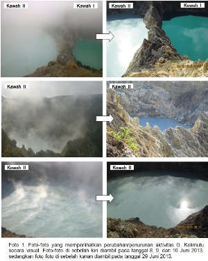
Comparison of the crater lakes at Kelimutu volcano, Indonesia in June (l) and July (r) (Credit: VSI)
Geologic summary: Kelimutu is a small, but well-known Indonesian volcano in central Flores Island with three summit crater lakes of varying colors. The western lake, Tiwi Ata Mbupu (Lake of Old People) is commonly blue. Tiwu Nua Muri Kooh Tai (Lake of Young Men and Maidens) and Tiwu Ata Polo (Bewitched, or Enchanted Lake), which share a common crater wall, are commonly green- and red-colored, respectively, although lake colors vary periodically. Active upwelling, probably fed by subaqueous fumaroles, occurs at the two eastern lakes. The scenic lakes are a popular tourist destination and have been the source of minor phreatic eruptions in historical time. The summit of the compound 1639-m-high Kelimutu volcano is elongated 2 km in a WNW-ESE direction; the older cones of Kelido and Kelibara are located respectively 3 km to the north and 2 km to the south.
POPOCATEPETL, México
19.023°N, 98.622°W; summit elev. 5426 m
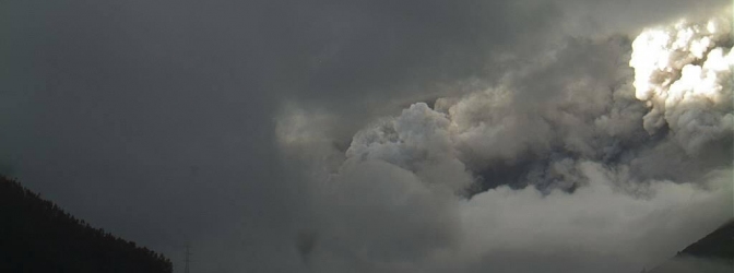
CENAPRED reported that scientists aboard an overflight of Popocatépetl on 10 July confirmed the presence of a new lava dome that was 250 m wide and 20 m thick. During 10-16 July seismicity indicated continuing gas-and-steam emissions that sometimes contained ash; cloud cover often prevented visual confirmation. Incandescence from the crater was observed at night during 9-11 July. Plumes with small amounts of ash were observed at 1556 and 1736 on 10 July, and an explosion was detected at 2259. Medium-sized explosions at 1949 on 11 July, and at 0137 and 0300 on 12 July, ejected incandescent tephra 2 km onto the E flank and 1 km onto the N flank. According to a news article, on 12 July a flight into and out of México City’s (65 km NW) international airport was canceled and operations at a small airport in Puebla (~50 km to the E) were suspended. Early on 13 July a gas-and-ash plume was observed drifting NE. During 13-14 July steam, gas, and ash emissions rose from the SE part of the crater, some incandescence from the crater was observed, and a dense steam-and-gas plume was noted. On 15 July a plume of steam, gas, and ash rose 1 km and drifted W. During an overflight later that day scientists observed a 200-m-wide and 20-to-30 m deep crater where the lava dome had been; explosions during the previous few days had destroyed the dome. At 0036 on 16 July a steam-and-gas plume containing minor amounts of ash rose from the crater. Incandescence emanating from the crater was also observed early that day. The Alert Level remained at to Yellow, Phase Three.

Popocatepetl volcano, Mexico on July 13, 2013 (Credit: CENAPRED)
Geologic summary: Popocatépetl, whose name is the Aztec word for smoking mountain, towers to 5,426 m 70 km SE of Mexico City and is North America's second-highest volcano. Frequent historical eruptions have been recorded since the beginning of the Spanish colonial era. A small eruption on 21 December 1994 ended five decades of quiescence. Since 1996 small lava domes have incrementally been constructed within the summit crater and destroyed by explosive eruptions. Intermittent small-to-moderate gas-and-ash eruptions have continued, occasionally producing ashfall in neighboring towns and villages.
SHIVELUCH, Central Kamchatka (Russia)
56.653°N, 161.360°E; summit elev. 3283 m
Based on visual observations and analyses of satellite data, KVERT reported that during 5-12 July a viscous lava flow effused on the N flank of Shiveluch's lava dome, accompanied by hot avalanches, incandescence, and fumarolic activity. Ash plumes as high as 4.5 km (14,800 ft) a.s.l. were observed during 5-6 July. Satellite images detected a daily thermal anomaly. The Aviation Color Code remained at Orange.
Geologic summary: The high, isolated massif of Shiveluch volcano (also spelled Sheveluch) rises above the lowlands NNE of the Kliuchevskaya volcano group and forms one of Kamchatka's largest and most active volcanoes. The currently active Molodoy Shiveluch lava-dome complex was constructed during the Holocene within a large breached caldera formed by collapse of the massive late-Pleistocene Strary Shiveluch volcano. At least 60 large eruptions of Shiveluch have occurred during the Holocene, making it the most vigorous andesitic volcano of the Kuril-Kamchatka arc. Frequent collapses of lava-dome complexes, most recently in 1964, have produced large debris avalanches whose deposits cover much of the floor of the breached caldera. Intermittent explosive eruptions began in the 1990s from a new lava dome that began growing in 1980. The largest historical eruptions from Shiveluch occurred in 1854 and 1964.
TUNGURAHUA, Ecuador
1.467°S, 78.442°W; summit elev. 5023 m
IG reported that seismic activity at Tungurahua was at low levels during 10-11 July, increased to moderate levels on 12 July, and increased again to moderate-to-high levels on 13 July; the number and type of events gradually and constantly increased. Cloud cover prevented visual observations of the crater. A total of 266 long-period events were recorded from 1500 on 13 July through the time of a large explosion at 0647 on 14 July, which was heard in areas as far as Guayaquil (about 180 km SW).
At 0651 an ash plume generated by the explosion rose 5.1 km above the crater and several significant pyroclastic flows descended the Achupashal ravine (NW). Continuous tremor was detected until 0840, and then seismicity dramatically decreased. At 0842 the plume rose to 8.3 km above the crater and drifted N, W, and S. At 0930 the plume drifted N and was observed drifting over the E parts of Quito (130 km N). Heavy amounts of ash and tephra fell in areas near the volcano including Bilbao (W, 4 cm diameter), Chacauco (NW, 5 cm diameter), Cotaló (8 km NW), Cahuají (8 km SW), Choglontus (SW), El Manzano (8 km SW), Puela (8 km SW), and Penipe (15 km SW); thinner deposits were reported in towns including Pelileo (8 km N), Ambato (31 km N), Cevallos (23 km NW), Colta (45 km SW), Guanujo (65 km WSW), and Guaranda (65 km WSW), and in the cantons of Guano (30 km SW), Valencia, Empalme, Buena Fé, and areas in the province of Manabi (180 km NW). According to news articles, over 200 people were evacuated from Cusua, Chacauco, and Juive. On 15 July steam plumes were observed rising from the crater during times of better visibility. Long-period earthquakes and tremor were detected during 15-16 July. Ashfall was reported in El Manzano on 16 July; cloud cover continued to prevent observations of the crater.
Ash emission column generated by the explosion at 11:47 UTC on July 14, 2013 at Tungurahua volcano, Ecuador (Credit: OVT – IGEPN)
Geologic summary: The steep-sided Tungurahua stratovolcano towers more than 3 km above its northern base. It sits ~140 km S of Quito, Ecuador's capital city, and is one of Ecuador's most active volcanoes. Historical eruptions have all originated from the summit crater. They have been accompanied by strong explosions and sometimes by pyroclastic flows and lava flows that reached populated areas at the volcano's base. The last major eruption took place from 1916 to 1918, although minor activity continued until 1925. The latest eruption began in October 1999 and prompted temporary evacuation of the town of Baños on the N side of the volcano.
UBINAS, Perú
16.355°S, 70.903°W; summit elev. 5672 m
The Buenos Aires VAAC reported that, although a pilot reported an ash plume from Ubinas rising to an altitude of 5.5 km (18,000 ft) a.s.l. and drifting W on 4 July, there was no ash detected in clear satellite
images.
Geologic summary: A small, 1.2-km-wide caldera that cuts the top of Ubinas, Peru's most active volcano, gives it a truncated appearance. Ubinas is the northernmost of three young volcanoes located along a regional structural lineament about 50 km behind the main volcanic front of Peru. The upper slopes of the stratovolcano, composed primarily of Pleistocene andesitic lava flows, steepen to nearly 45 degrees. The steep-walled, 150-m-deep summit caldera contains an ash cone with a 500-m-wide funnel-shaped vent that is 200 m deep. Debris-avalanche deposits from the collapse of the SE flank of Ubinas extend 10 km from the volcano. Widespread Plinian pumice-fall deposits from Ubinas include some of Holocene age. Holocene lava flows are visible on the volcano's flanks, but historical activity, documented since the 16th century, has consisted of intermittent minor explosive eruptions.
ULAWUN, New Britain
5.05°S, 151.33°E; summit elev. 2334 m
RVO reported that activity at Ulawun was low during 1-14 July. Emissions from the summit crater consisted of white vapor during 1-7 July, and then changed to occasionally sub-continuous, light gray ash clouds during 8 and 11-14 July. Ash clouds changed to gray-brown on 14 July.
Seismic activity was low from 1 July through the early part of 13 July. RSAM increased from about 0700 on 14 July onwards with the emergence of continuous volcanic tremors until it reached a peak of 700 just after 0300 on 15 July. RVO noted that the last significant volcanic tremors at Ulawun were recorded in May and June 2012.
Geologic summary: The symmetrical basaltic to andesitic Ulawn stratovolcano is the highest volcano of the Bismarck arc, and one of Papua New Guinea's most frequently active. Ulawun rises above the N coast of New Britain opposite Bamus volcano. The upper 1,000 m of the 2,334-m-high volcano is unvegetated. A steep-walled valley cuts the NW side of the volcano, and a flank lava-flow complex lies to the S of this valley. Historical eruptions date back to the beginning of the 18th century. Twentieth-century eruptions were mildly explosive until 1967, but after 1970 several larger eruptions produced lava flows and basaltic pyroclastic flows, greatly modifying the summit crater.
Ongoing activity
BATU TARA, Komba Island (Indonesia)
7.792°S, 123.579°E; summit elev. 748 m
Based on analyses of satellite imagery and wind data, the Darwin Volcanic Ash Advisory Centre (VAAC) reported that on 14 July an ash plume from Batu Tara rose to an altitude of 2.1 km (7,000 ft) a.s.l. and drifted about 40 km NW.
Geologic summary: The small isolated island of Batu Tara in the Flores Sea about 50 km north of Lembata (formerly Lomblen) Island contains a scarp on the eastern side similar to the Sciara del Fuoco of Italy's Stromboli volcano. Vegetation covers the flanks of Batu Tara to within 50 m of the 748-m-high summit. Batu Tara lies north of the main volcanic arc and is noted for its potassic leucite-bearing basanitic and tephritic rocks. The first historical eruption from Batu Tara, during 1847-52, produced explosions and a lava flow.
CHIRINKOTAN, Kuril Islands
48.980°N, 153.480°E; summit elev. 724 m
Based on analysis of satellite images, SVERT reported that weak steam-and-gas emissions from Chirinkotan were observed on 12 July and a thermal anomaly was detected during 12-13 July. The Aviation Color Code remained at Yellow.
Geologic summary: The small, mostly unvegetated 3-km-wide island of Chirinkotan occupies the far end of an E-W-trending volcanic chain that extends nearly 50 km west of the central part of the main Kuril Islands arc. Chirinkotan is the emergent summit of a volcano that rises 3000 m from the floor of the Kuril Basin. A small 1-km-wide caldera about 300-400 m deep is open to the SE. Lava flows from a cone within the breached crater reached the north shore of the island. Historical eruptions have been recorded at Chirinkotan since the 18th century. Fresh lava flows also descended the SE flank of Chirinkotan during an eruption in the 1880s that was observed by the English fur trader Captain Snow.
CHIRPOI, Kuril Islands (Russia)
46.525°N, 150.875°E; summit elev. 742 m
SVERT reported that a thermal anomaly over Snow, a volcano of Chirpoi, was detected in satellite images on 14 July. The Aviation Color Code remained at Yellow.
Geologic summary: Chirpoi, a small island lying between the larger islands of Simushir and Urup, contains a half dozen volcanic edifices constructed within an 8-9 km wide, partially submerged caldera. The southern rim of the caldera is exposed on nearby Brat Chirpoev Island. Two volcanoes on Chirpoi Island have been historically active. The symmetrical Cherny volcano, which forms the 691 m high point of the island, erupted twice during the 18th and 19th centuries. The youngest volcano, Snow, originated between 1770 and 1810. It is composed almost entirely of lava flows, many of which have reached the sea on the southern coast. No historical eruptions are known from 742-m-high Brat Chirpoev, but its youthful morphology suggests recent strombolian activity.
KILAUEA, Hawaii (USA)
19.421°N, 155.287°W; summit elev. 1222 m
During 10-16 July HVO reported that the circulating lava lake occasionally rose and fell in the deep pit within Kilauea's Halema'uma'u Crater. The plume from the vent continued to deposit variable amounts of ash, spatter, and Pele's hair onto nearby areas. At Pu'u 'O'o Crater, glow emanated from three spatter cones and a small lava pond on the E part of the crater floor. The Kahauale’a 2 lava flow branches, fed by the NE spatter cone, were active as far N as 2.6 km and as far NNW as 1.9 km, and burned forest in both areas. Peace Day activity, fed by lava tubes extending from Pu'u 'O'o, consisted of some breakout activity on the pali and coastal plain, and ocean entries at locations inside and outside the National Park boundary.
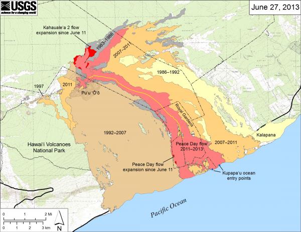
Current lava flows at Kilauea volcano, Hawaii on June 27, 2013 (Credit: HVO)
Geologic summary: Kilauea, one of five coalescing volcanoes that comprise the island of Hawaii, is one of the world's most active volcanoes. Eruptions at Kilauea originate primarily from the summit caldera or along one of the lengthy E and SW rift zones that extend from the caldera to the sea. About 90% of the surface of Kilauea is formed of lava flows less than about 1,100 years old; 70% of the volcano's surface is younger than 600 years. A long-term eruption from the East rift zone that began in 1983 has produced lava flows covering more than 100 sq km, destroying nearly 200 houses and adding new coastline to the island.
KIZIMEN, Eastern Kamchatka (Russia)
55.130°N, 160.32°E; summit elev. 2376 m
KVERT reported that during 5-12 July moderate seismic activity continued at Kizimen. Video and satellite data showed that lava continued to extrude from the summit, producing incandescence, strong gas-and-steam activity, and hot avalanches on the W and E flanks. A thermal anomaly was detected in satellite images on 5 and 9 July. The Aviation Color Code remained at Orange.
Geologic summary: Kizimen is an isolated, conical stratovolcano that is morphologically similar to Mount St. Helens prior to its 1980 eruption. The summit of Kizimen consists of overlapping lava domes, and blocky lava flows descend the flanks of the volcano, which is the westernmost of a volcanic chain north of Kronotsky volcano. The 2,376-m-high Kizimen was formed during four eruptive cycles beginning about 12,000 years ago and lasting 2,000-3,500 years. The largest eruptions took place about 10,000 and 8300-8400 years ago, and three periods of longterm lava-dome growth have occurred. The latest eruptive cycle began about 3,000 years ago with a large explosion and was followed by lava-dome growth lasting intermittently about 1,000 years. An explosive eruption about 1,100 years ago produced a lateral blast and created a 1.0 x 0.7 km wide crater breached to the NE, inside which a small lava dome (the fourth at Kizimen) has grown. A single explosive eruption, during 1927-28, has been recorded in historical time.
MANAM, Northeast of New Guinea (SW Pacific)
4.080°S, 145.037°E; summit elev. 1807 m
RVO reported that the increased activity at Manam noted during 17-18 June continued on 19 June, and then declined on 20 June. On 19 June diffuse dark gray ash plumes that rose 200 m above the summit crater were accompanied by deep, loud explosive and booming noises occurring at short intervals. Very loud explosions accompanied by shock waves were heard at much longer intervals. Observers noted ejected incandescent lava fragments at night.
Decreased activity that started on 20 June carried through 30 June, and was characterized by diffuse ash emissions at the beginning of the period changing to diffuse white vapor emissions towards the end. Diffuse gray emissions rose from Main Crater during 19-22 June; explosion and booming noises were reported during 19-20 June. Seismicity was low. Activity at Southern Crater and Main Crater was low during 1-14 July; both craters emitted white vapor.
Geologic summary: The 10-km-wide island of Manam, lying 13 km off the northern coast of mainland Papua New Guinea, is one of the country's most active volcanoes. Four large radial valleys extend from the unvegetated summit of the conical 1807-m-high basaltic-andesitic stratovolcano to its lower flanks. These "avalanche valleys," regularly spaced 90 degrees apart, channel lava flows and pyroclastic avalanches that have sometimes reached the coast. Two summit craters are present; both are active, although most historical eruptions have originated from the southern crater, concentrating eruptive products during much of the past century into the SE avalanche valley. Frequent historical eruptions, typically of mild-to-moderate scale, have been recorded at Manam since 1616. Occasional larger eruptions have produced pyroclastic flows and lava flows that reached flat-lying coastal areas and entered the sea, sometimes impacting populated areas.
NEVADO DEL RUIZ, Colombia
4.895°N, 75.322°W; summit elev. 5321 m
Servicio Geológico Colombiano’s (SGC) Observatorio Vulcanológico and Sismológico de Manizales reported that during 8-14 July gas-and-steam plumes rose 600 m above Nevado del Ruiz’s crater and drifted NW. Sulfur dioxide emissions were significant. Seismicity was dominated by volcano-tectonic signals. The earthquakes were located NE, S, and SW of Arenas Crater; the largest was a M (local) 2.1 located SW of Arenas Crater at a depth of 3.4 km. Shallow seismicity associated with fluid movement occurred S and SE of the crater. During 11-12 July continuous volcanic tremor associated with emissions was detected; ashfall was reported in Los Nevados Natural Park and in some parts of Manizales (30 km NW). The Alert Level remained at III (Yellow; "changes in the behavior of volcanic activity").
Geologic summary: Nevado del Ruiz is a broad, glacier-covered volcano in central Colombia that covers >200 sq km. Three major edifices, composed of andesitic and dacitic lavas and andesitic pyroclastics, have been constructed since the beginning of the Pleistocene. The modern cone consists of a broad cluster of lava domes built within the summit caldera of an older Ruiz volcano. The 1-km-wide, 240-m-deep Arenas crater occupies the summit. Steep headwalls of massive landslides cut the flanks of Nevado del Ruiz. Melting of its summit icecap during historical eruptions, which date back to the 16th century, has resulted in devastating lahars, including one in 1985 that was South America's deadliest eruption.
RABAUL, New Britain
4.271°S, 152.203°E; summit elev. 688 m
RVO reported that during 16 June-14 July white-to-light-gray plumes sometimes containing fine ash rose at most 2 km from Rabaul caldera's Tavurvur cone and drifted NW and SE. Roaring and rumbling noises also continued, and seismicity was low. Ashfall was reported in areas downwind including Rabaul town (3-5 km NW) during 16-30 June. The lava dome on the crater floor of Tavurvur continued to glow; on 26 June and 4 July observers near the dome noted brief incandescence at the vent associated with strong and rapid venting. Explosions during 10-14 July generated dense gray ash clouds that drifted NW, causing ashfall between Namanula Hill (3 km W) and Malaguna No.1 (NW), and Pilapila and Tavui Point.
Geologic summary: The low-lying Rabaul caldera on the tip of the Gazelle Peninsula at the NE end of New Britain forms a broad sheltered harbor. The outer flanks of the 688-m-high asymmetrical pyroclastic shield volcano are formed by thick pyroclastic-flow deposits. The 8 x 14 km caldera is widely breached on the E, where its floor is flooded by Blanche Bay. Two major Holocene caldera-forming eruptions at Rabaul took place as recently as 3,500 and 1,400 years ago. Three small stratovolcanoes lie outside the northern and NE caldera rims. Post-caldera eruptions built basaltic-to-dacitic pyroclastic cones on the caldera floor near the NE and western caldera walls. Several of these, including Vulcan cone, which was formed during a large eruption in 1878, have produced major explosive activity during historical time. A powerful explosive eruption in 1994 occurred simultaneously from Vulcan and Tavurvur volcanoes and forced the temporary
abandonment of Rabaul city.
REVENTADOR, Ecuador
0.077°S, 77.656°W; summit elev. 3562 m
IG reported that during 10-16 July seismic activity at Reventador was high; weather conditions mostly prevented visual observations of the crater. During partially clear views on 13 July, observers noted a new lava flow on the S flank. At 1500 on 15 July continuous tremor was detected, which intensified at 2000, and then decreased at midnight. Intense Strombolian activity during this time was characterized by variable-magnitude explosions and roaring. Explosions generated blocks that rolled down the flanks. Incandescence from the lava flow on the S flank was observed.
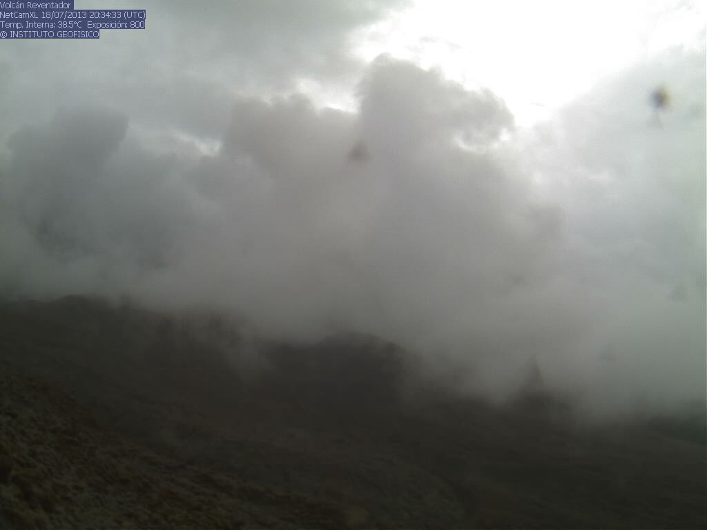
Recent activity at Reventador volcano, Ecuador (Credit: IGEPN)
Geologic summary: Reventador is the most frequently active of a chain of Ecuadorian volcanoes in the Cordillera Real, well E of the principal volcanic axis. It is a forested stratovolcano that rises above the remote jungles of the western Amazon basin. A 3-km-wide caldera breached to the E was formed by edifice collapse and is partially filled by a young, unvegetated stratovolcano that rises about 1,300 m above the caldera floor. Reventador has been the source of numerous lava flows as well as explosive eruptions that were visible from Quito in historical time. Frequent lahars in this region of heavy rainfall have constructed a debris plain on the eastern floor of the caldera.
SAKURA-JIMA, Kyushu
31.585°N, 130.657°E; summit elev. 1117 m
JMA reported that 17 explosions at Sakura-jima's Showa Crater were detected during 8-15 July; incandescence from the crater was occasionally observed at night. Explosions during 10-11 July generated ash plumes that rose 3-3.4 km above the crater. Based on information from JMA, the Tokyo VAAC reported that during 10-16 July explosions generated plumes that rose to altitudes of 1.5-4.6 km (5,000-15,000 ft) a.s.l. and drifted N, NE, ENE, and E. Ash was detected in satellite images. During 10 and 14-15 July pilots observed ash plumes that rose to altitudes of 1.5-4 km (5,000-13,000 ft) a.s.l. and drifted NE and E.
Geologic summary: Sakura-jima, one of Japan's most active volcanoes, is a post-caldera cone of the Aira caldera at the northern half of Kagoshima Bay. Eruption of the voluminous Ito pyroclastic flow was associated with the formation of the 17 x 23-km-wide Aira caldera about 22,000 years ago. The construction of Sakura-jima began about 13,000 years ago and built an island that was finally joined to the Osumi Peninsula during the major explosive and effusive eruption of 1914. Activity at the Kita-dake summit cone ended about 4,850 years ago, after which eruptions took place at Minami-dake. Frequent historical eruptions, recorded since the 8th century, have deposited ash on Kagoshima, one of Kyushu's largest cities, located across Kagoshima Bay only 8 km from the summit. The largest historical eruption took place during 1471-76.
TOLBACHIK, Central Kamchatka (Russia)
55.830°N, 160.330°E; summit elev. 3682 m
KVERT reported that the S fissure along the W side of Tolbachinsky Dol, a lava plateau on the SW side of Tolbachik, continued to produce very fluid lava flows during 5-12 July that traveled to the W, S, and E sides of the plateau. Cinder cones continued to grow along the S fissure and weak gas-and-steam plumes were observed. A large thermal anomaly on the N part of Tolbachinsky Dol was visible daily in satellite imagery. The Aviation Color Code remained at Orange.
Geologic summary: The massive Tolbachik basaltic volcano is located at the southern end of the dominantly andesitic Kliuchevskaya volcano group. The Tolbachik massif is composed of two overlapping, but morphologically dissimilar volcanoes. The flat-topped Plosky Tolbachik shield volcano with its nested Holocene Hawaiian-type calderas up to 3 km in diameter is located east of the older and higher sharp-topped Ostry Tolbachik stratovolcano. The summit caldera at Plosky Tolbachik was formed in association with major lava effusion about 6500 years ago and simultaneously with a major southward-directed sector collapse of Ostry Tolbachik volcano. Lengthy rift zones extending NE and SSW of the volcano have erupted voluminous basaltic lava flows during the Holocene, with activity during the past two thousand years being confined to the narrow axial zone of the rifts. The 1975-76 eruption originating from the SSW-flank fissure system and the summit was the largest historical basaltic eruption in Kamchatka.
VENIAMINOF, Alaska Peninsula
56.17°N, 159.38°W; summit elev. 2507 m
AVO reported that the ongoing low-level eruption of Veniaminof, characterized by lava effusion and emission of minor amounts of ash and steam, continued during 10-16 July, indicated by nearly continuous volcanic tremor and occasional small explosions detected by the seismic network. Satellite images showed elevated surface temperatures at the cinder cone inside the caldera consistent with lava effusion. Images also showed that most of the lava flows traveled S of the cone a short distance (hundreds of meters). The web camera in Perryville (32 km SSE) recorded very weak emissions of vapor, possibly containing minor amounts of ash, within the caldera during 9-10 July; incandescence from the cone was visible during 10-11 July. The Volcano Alert Level remained at Watch and the Aviation Color code remained at Orange.
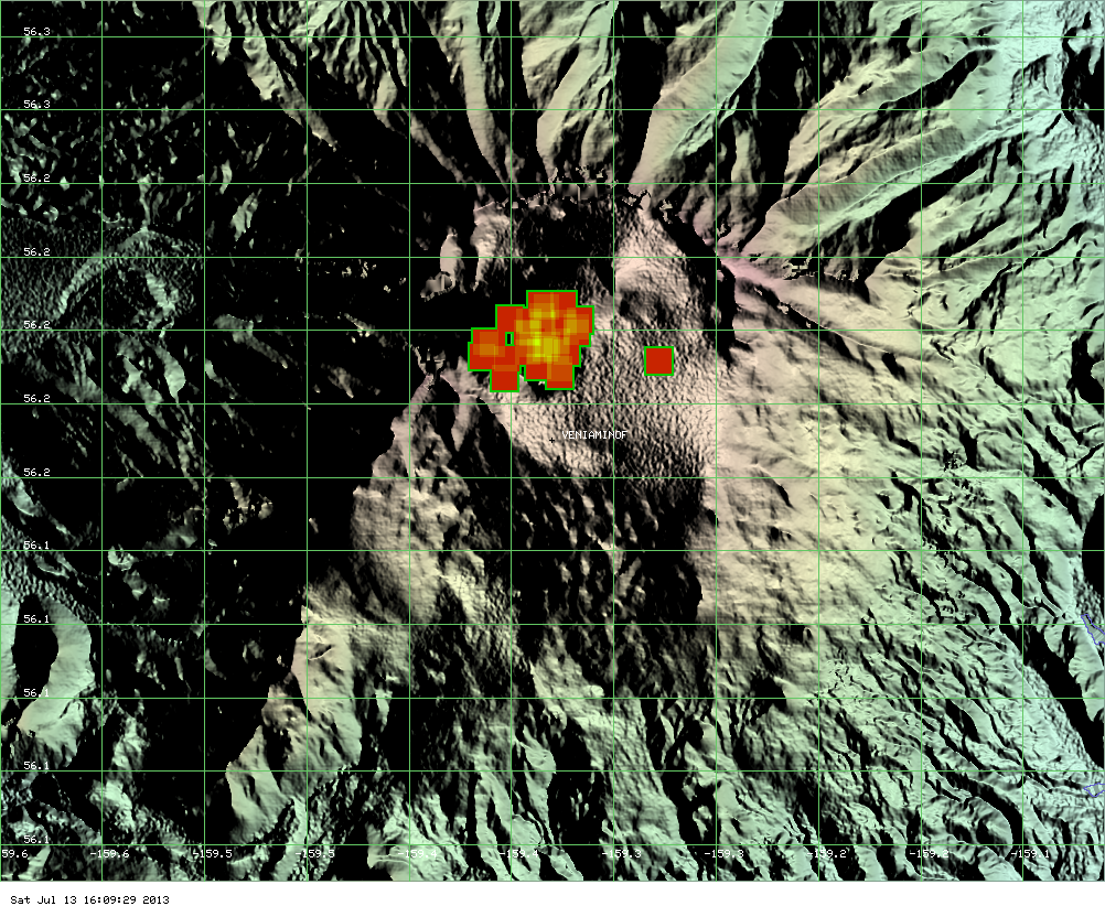
Hotspot at Veniaminof volcano, Alaska on July 13, 2013 (Credit: MODIS/MODVOLC)
Geologic summary: Massive Veniaminof volcano, one of the highest and largest volcanoes on the Alaska Peninsula, is truncated by a steep-walled, 8 x 11 km, glacier-filled caldera that formed around 3,700 years ago. The caldera rim is up to 520 m high on the N, is deeply notched on the W by Cone Glacier, and is covered by an ice sheet on the S. Post-caldera vents are located along a NW-SE zone bisecting the caldera that extends 55 km from near the Bering Sea coast, across the caldera, and down the Pacific flank. Historical eruptions probably all originated from the westernmost and most prominent of two intra-caldera cones, which reaches an elevation of 2,156 m and rises about 300 m above the surrounding icefield. The other cone is larger, and has a summit crater or caldera that may reach 2.5 km in diameter, but is more subdued and barely rises above the glacier surface.
Source: GVP
Commenting rules and guidelines
We value the thoughts and opinions of our readers and welcome healthy discussions on our website. In order to maintain a respectful and positive community, we ask that all commenters follow these rules.