
Tropical Storm “Choi-wan” forms near the Philippines
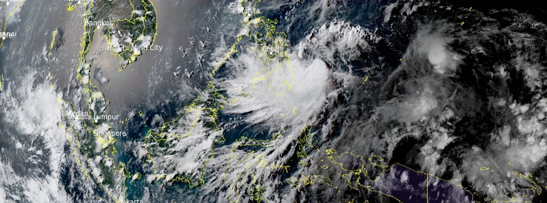
Featured image: Tropical Storm "Choi-wan" at 08:20 UTC on May 31, 2021. Credit: JMA/Himawari-8, RAMMB/CIRA, TW
Tropical Storm "Choi-wan" formed between Palau and the Philippines on May 30, 2021, as the third named storm of the 2021 Pacific typhoon season. On the current forecast track, Choi-wan will likely remain over the Philippine Sea over the next 5 days. Choi-wan is forecast to gradually intensify and may reach the severe tropical storm category by Wednesday, June 2 before starting to weaken.
At 06:00 UTC May 31, Tropical Storm Choi-wan (known as Dante in the Philippines) was located about 1 295 km (805 miles) southeast of Manila, Philippines.
Its maximum 10-minute sustained winds were 65 km/h (40 mph) with gusts up to 95 km/h (60 mph). Maximum 1-minute sustained winds were 85 km/h (50 mph).
The minimum central barometric pressure was 1 000 hPa, and the system was moving northwest at 20 km/h (10 mph).
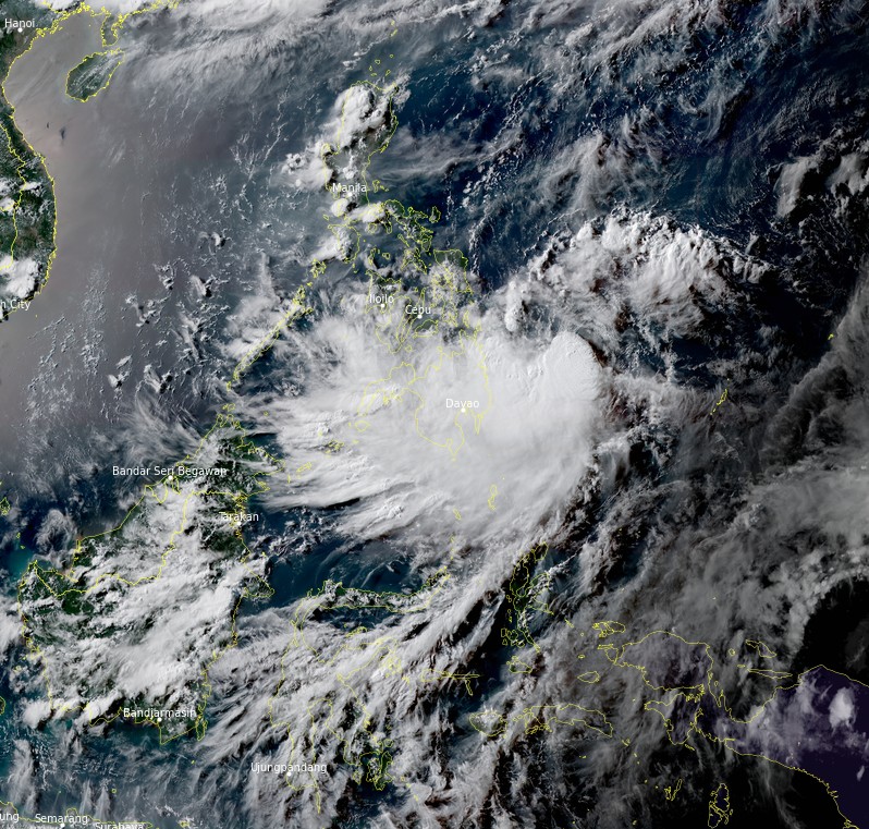
On the forecast track, Choi-wan will likely remain over the Philippine Sea over the next 5 days.
The tropical storm is forecast to continue moving northwestward in the next 36 hours. Afterward, the tropical cyclone will turn north-northwestward on Wednesday, June 2, and generally northeastward on Friday, June 4.
Choi-wan is forecast to gradually intensify and may reach the severe tropical storm category by Wednesday, June 2 before starting to weaken.

Image credit: JTWC
In the anticipation of the arrival of strong winds caused by this storm, the Philippine Atmospheric, Geophysical and Astronomical Services Administration (PAGASA) has issued Tropical Cyclone Wind Signal (TCWS) #1 for the eastern portion of Northern Samar (Mapanas, Gamay, Lapinig, Palapag, Laoang) and the northeastern portion of Eastern Samar (Arteche, San Policarpo).
Today until tomorrow afternoon (LT), light to moderate with at times heavy rains will be experienced over Caraga, Davao Region, Eastern Visayas, Bukidnon, and Misamis Oriental due to the outer rainbands of Choi-wan (Dante).
Under these conditions, isolated to scattered flooding (including flash floods) and rain-induced landslides are possible, especially in areas that are highly or very highly susceptible to these hazards as identified in hazard maps. Adjacent or nearby areas may also experience flooding in the absence of such rainfall occurrence due to surface runoff or swelling of river channels, PAGASA warns.
In the next 24 hours, moderate to rough seas (1.2 to 2.8 m / 3.9 to 9.2 feet) will be experienced over the eastern seaboards of Visayas and Mindanao.
Mariners of small seacrafts are advised to take precautionary measures when venturing out to sea. Inexperienced mariners should avoid navigating in these conditions.
Tropical Storm "Choi-wan" at 08:20 UTC on May 31, 2021. Credit: JMA/Himawari-8, RAMMB/CIRA, TW
"The public and disaster risk reduction and management offices concerned are advised to take all necessary measures to protect life and property," PAGASA said.
"Persons living in areas identified to be highly or very highly susceptible to these hazards are advised to follow evacuation and other instructions from local officials. For heavy rainfall warnings, thunderstorm/rainfall advisories, and other severe weather information specific to your area, please monitor products issued by your local PAGASA Regional Services Division."
I'm a dedicated researcher, journalist, and editor at The Watchers. With over 20 years of experience in the media industry, I specialize in hard science news, focusing on extreme weather, seismic and volcanic activity, space weather, and astronomy, including near-Earth objects and planetary defense strategies. You can reach me at teo /at/ watchers.news.
Commenting rules and guidelines
We value the thoughts and opinions of our readers and welcome healthy discussions on our website. In order to maintain a respectful and positive community, we ask that all commenters follow these rules.