
Cold air invading southern United States, ‘killing frost’ expected
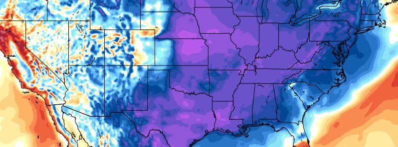
Featured image: 2m temperature anomaly GFS model for November 10 (model run 12:00 UTC, November 8). Credit: GFS, Tropical Tidbits, TW
Accumulating snow will continue to impact the Central Plains, from Kansas and Nebraska toward the Midwest today into tonight with several inches expected, NWS said today. Anomalously cold air, way below average for this time of year, will advance south into New Mexico, Oklahoma and Texas and continue into Wisconsin, the Upper Peninsula of Michigan and Lower Michigan. Frost and freeze alerts have been issued by the National Weather Service across at least nine states.
A preview of winter-like temperatures is already in place for the central and northern Plains with today's highs ranging from the teens to 30s (-8 to -1 °C) down to the Kansas/Oklahoma border, NWS forecaster Otto noted Thursday, November 8, 2018. Several inches of snow have also been reported across Nebraska and Kansas during afternoon hours.
The cold temperatures will continue to advance south into New Mexico, Oklahoma and Texas for Friday with forecast maximum temperatures of 15 to 25 °F (8 to 14 °C) below early November averages.
The combination of the anomalously cold air and an upper level disturbance will spread snow into northern Wisconsin, the U.P. of Michigan along with Lower Michigan by early Friday morning as a surface cyclone begins to organize over the Ohio Valley.
By Friday night and Saturday morning, sections of the Mid South will experience a killing frost. Sub-freezing temperatures will dip as far south as northern Mississippi, Meteorologist Joe Astolfi of the Weather Nation said.
Cities such as Wichita and Oklahoma City will experience temperatures at or below the freezing mark while some parts of Missouri will fall into the 10s. Kansas City runs the risk of setting a new record cold low temperature Saturday morning.
Areas along and immediately north of a quasi-stationary front currently in place across the Gulf Coast will experience unsettled weather with showers and thunderstorms into the day on Friday.
As a powerful upper-level system advances eastward from the upper Midwest to the lower Great Lakes region through Saturday morning, low pressure at the surface will begin to take shape along the Mid-Atlantic Coast.
The surface low will deepen and track rather quickly across coastal New England but will be accompanied by locally heavy rain and thunderstorms.
Winds will also begin to increase Friday night across the Northeast for coastal locations and the mountains in the wake of the departing storms system.
Northwesterly winds wrapping around the low center will usher in a much colder airmass with lake effect snow showers developing downwind of Lakes Erie and Ontario early Saturday.
I'm a dedicated researcher, journalist, and editor at The Watchers. With over 20 years of experience in the media industry, I specialize in hard science news, focusing on extreme weather, seismic and volcanic activity, space weather, and astronomy, including near-Earth objects and planetary defense strategies. You can reach me at teo /at/ watchers.news.
Snow be here on monday, SW Oklahoma, too early and many frozen mornings to come, too early. Nibiru here soon, more and more bigger events to come in with it.