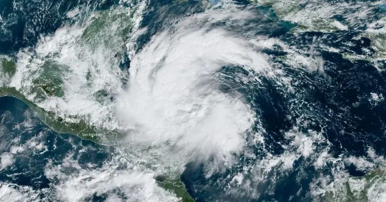
• Life-threatening and potentially catastrophic flash flooding and mudslides forecast for Honduras’ northern coast

    The northern coast of Honduras is bracing for life-threatening and potentially catastrophic flash flooding and mudslides as Tropical Depression Nineteen (TD19) moves westward, with up to 760 mm (30 inches) of rainfall anticipated, before the storm shifts toward Belize and the Yucatán Peninsula early next week. The depresion is forecast to strengthen into Tropical Storm “Sara” and meander near the northern coast of Honduras late Friday and through the weekend.

  • Super Typhoon “Usagi” makes landfall over Cagayan, Philippines

    Super Typhoon “Usagi” – known in the Philippines as Ofel, made landfall near Baggao in the Cagayan region of the Philippines at 13:30 local time (LT) on November 14, 2024, weakening to a typhoon upon landfall. The system is expected to bring strong winds and heavy rains across the Philippines, with authorities raising Wind Signal numbers 3 and 4 in  regions where significant damage is anticipated.

  • Severe flooding in Catania, Sicily, Italy

    Continuous rainfall led to flooding and infrastructural damage in Catania and nearby areas in Sicily, Italy, on Wednesday, November 13, 2024. No dead or missing persons have been reported. In Acireale, firefighters responded to a collapsed perimeter wall, and no injuries or fatalities were reported.

  • Second DANA storm impacting eastern Spain after historic October flooding

    The Spanish Meteorological Agency (AEMET) issued a severe weather advisory on November 12, 2024, warning of heavy rainfall and potential flooding in the Mediterranean and Andalusian coastal regions through November 15. Rainfall is expected to reach 150 mm (5.9 inches) in 24 hours in some areas, only two weeks after previous severe flooding in eastern Spain.

  • Significant rain and snow event expected for Northern California and Pacific Northwest

    A strong Atmospheric River is set to bring significant low-elevation rain and high-elevation snow to the Pacific Northwest and Northern California beginning Tuesday evening, November 12, 2024. The system will continue moving eastward, impacting a wide swath of the western and central United States with varied precipitation, including rain, snow, and thunderstorms.

  • Edisto River crest breaks 1928 record, causing dam failures and damaging roads and bridges in Orangeburg, South Carolina

    A plume of moisture from Hurricane “Rafael” moved northward into the Southeastern United States and collided with a stationary front over South Carolina, causing intense rainfall in Orangeburg County on November 6 and 7, 2024. The extreme rainfall, totaling 180 – 380 mm (7 – 15 inches) in 24 hours, overwhelmed local ponds and dams, leading to failures that sent water downstream, damaging bridges and roads near Norway, South Carolina.

  • Pacific Northwest and Northern California brace for incoming atmospheric rivers

    Two atmospheric rivers are set to bring heavy rainfall and flood risks to the Pacific Northwest and Northern California from November 10 to November 14. The storms are expected to bring significant precipitation, with the heaviest rainfall forecast for the Olympic Peninsula and Cascade Mountains. The peak rainfall is predicted to occur between November 10 and November 13.

  • Impossible travel, near blizzard conditions, and historic snowfall totals expected in parts of New Mexico and Colorado

    A severe winter storm impacting parts of Colorado and New Mexico is expected to bring additional heavy snowfall on Friday, November 8, 2024. Parts of the area had already accumulated 25 – 50 cm (10 – 20 inches) of snow by Thursday night, November 7, prompting the Colorado governor to declare a disaster emergency for what could be Denver’s most severe snowstorm in 30 years. Snowfall rates of 2.5 – 5 cm per hour (1 – 2 inches per hour) are anticipated to continue across the region, with total snow accumulations forecast to reach 30 – 120 cm (1 – 4 feet) in some areas.