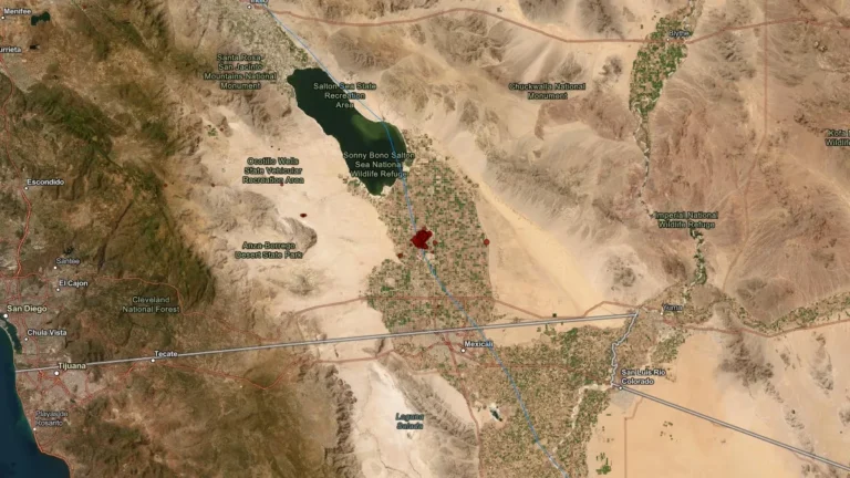
• Rare Moderate Risk (4/5) issued for Mid-Atlantic as severe thunderstorms raise threat of damaging winds and tornadoes

    A Moderate Risk (Level 4 of 5) for severe thunderstorms has been issued across parts of the Mid-Atlantic United States for Monday, March 16, 2026, as a powerful multi-hazard storm threatens over 100 million people across the U.S. Fast-moving storms capable of producing damaging winds and a few strong tornadoes are forecast to develop from the Carolinas into Virginia and Maryland during the afternoon and evening hours. A Moderate Risk is an unusually high severe weather category for the Mid-Atlantic and is not issued often for this region. The National Weather Service office serving the Washington, D.C. area described the setup as a “quite rare Day 2 Moderate Risk area” ahead of the event.

  • Snowstorm causes spinouts and closure of I-90 at Snoqualmie Pass, Washington

    Heavy snowfall caused multiple vehicle spinouts and crashes on I-90 at Snoqualmie Pass in Washington, forcing authorities to close the highway in both directions on March 13 and keep it closed overnight into March 14, 2026. Snoqualmie Pass received about 56 cm (22 inches) of new snow overnight, while the Summit at Snoqualmie reported about 107 cm (42 inches) over 48 hours during the storm.

  • Major winter storm brings blizzard conditions to Northern Plains and Great Lakes

    A major winter storm is affecting the Northern Plains and the western Great Lakes in the United States on March 15–16, bringing heavy snowfall, strong winds, and widespread blizzard conditions. Snowfall rates of up to 7.5 cm (3 inches) per hour and wind gusts of up to 95 km/h (60 mph) are forecast across parts of eastern South Dakota, Wisconsin, and Michigan as a strengthening low-pressure system moves toward southeastern Canada. Travel conditions are expected to become extremely dangerous across the affected region.

  • Red Flag Warnings issued for parts of Texas, New Mexico, Oklahoma and Colorado as critical fire weather spreads on March 15

    Strong winds and very dry air behind a powerful storm system are creating critical fire weather across parts of Texas, New Mexico, Oklahoma, and Colorado on March 15, 2026, prompting Red Flag Warnings across multiple forecast areas. Wind gusts may reach 105 km/h (65 mph), while relative humidity is forecast to fall as low as 6 to 15 percent in some areas, supporting rapid fire growth and spread.

  • Freeze Warnings and Watches issued across parts of Texas, Oklahoma, Arkansas, Louisiana, Mississippi, Alabama, Missouri, and Tennessee

    Freeze Warnings and Watches have been issued for parts of eight southern U.S. states as sub-freezing temperatures are forecast from March 16 into March 17, 2026. Temperatures could fall as low as −12°C (10°F) in the coldest parts of Arkansas, while many other areas are expected to bottom out in the −7°C to −2°C (19 to 28°F) range. Frost, freeze conditions, and gusty post-frontal winds may damage sensitive vegetation and, in the coldest areas, affect exposed outdoor plumbing.

  • Over 130 000 customers lose power across Hawaii as Kona low brings damaging winds and flash flooding

    Over 130 000 electricity customers across Hawaii lost power on March 13, 2026, as a powerful Kona low brought heavy rainfall, damaging winds, and thunderstorms to the islands. Wind gusts up to 126 km/h (78 mph) were recorded on Oʻahu while forecasters warned rainfall totals of 250–500 mm (10–20 inches) could raise the risk of flash flooding.

  • Extreme Heat Watches issued for California and Arizona as anomalous heat intensifies across parts of the Southwest

    Extreme Heat Watches have been issued for parts of California and Arizona as an anomalous and unusually prolonged heat event intensifies across the Southwest United States. Watches begin Monday, March 16, 2026, in parts of Southern California, then expand into parts of Arizona and southeast California later in the week, with some desert areas forecast to reach up to 43°C (109°F) and temperatures in some locations rising 11–17°C (20–30°F) above normal for mid-March.

  • Evacuation warning issued after possible Wahiawā Dam failure alert on Oʻahu, Hawaiʻi

    A potential failure of Wahiawā Dam on Oʻahu, Hawaiʻi, triggered an evacuation warning at 18:55 LT on March 13, 2026, for downstream communities, including Haleʻiwa and Waialua. Authorities said conditions existed that could lead to dam failure capable of causing catastrophic flooding, prompting residents to prepare for possible evacuation.

  • Blizzard Warnings issued for parts of South Dakota and Minnesota as heavy snow and strong winds threaten whiteout conditions

    Blizzard Warnings are in effect for parts of South Dakota and southwest Minnesota beginning late Saturday, March 14, 2026, as a major winter storm is forecast to bring heavy snow, blowing snow, ice in some areas, and wind gusts up to 80 to 90 km/h (50 to 55 mph). Forecasters warn that whiteout conditions could make travel extremely dangerous or impossible from Saturday night into Sunday, with some warning areas remaining under blizzard conditions into early Monday.

  • Kona low prompts statewide closures as severe weather threat intensifies across Hawaii

    A powerful Kona low on Friday, March 13, 2026, bringing widespread severe weather across the islands. The National Weather Service issued a Winter Storm Warning for the Big Island summits, where heavy snow and ice are forecast above 3 350 m (11 000 feet). Forecasters warned that persistent rainfall bands and severe thunderstorms could trigger flash flooding while damaging wind gusts affect multiple islands.