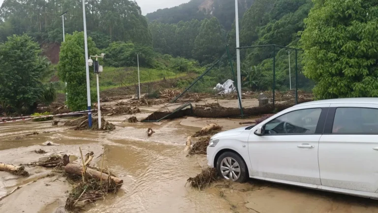
• Tropical Cyclone Narelle crosses Gascoyne coast with destructive winds and flooding, Western Australia

    Severe Tropical Cyclone Narelle made landfall just south of Coral Bay, Western Australia, at approximately 09:30 AWST (01:30 UTC) on March 27, 2026, as a Category 3 system. It brought wind gusts up to 195 km/h (121 mph), intense rainfall, and a dangerous storm tide along the Gascoyne coast. Severe weather conditions are continuing inland through the day and are forecast to persist into March 28.

  • Record March heat accelerates peak of wildflower bloom in Death Valley National Park

    A record-breaking March heat wave across the southwestern United States accelerated the wildflower bloom cycle in Death Valley National Park, causing peak conditions to occur earlier than typical seasonal patterns. The National Park Service (NPS) reported that lower elevation flowers have already begun setting seed following intense heat and high winds, while the National Weather Service (NWS) reported that hundreds of daily temperature records were set or tied across parts of the region.

  • Critical fire weather conditions forecast across central New Mexico into the southern High Plains

    Critical fire weather conditions are forecast across central New Mexico into the southern High Plains from Thursday morning, March 26, through early Friday, March 27, 2026, as sustained west-southwesterly winds of 30–40 km/h (20–25 mph), relative humidity as low as 5–15%, and record to near-record heat support rapid fire spread and drying of fine fuels.

  • Severe Tropical Cyclone Narelle to pass close to the North West Cape, bringing destructive winds to Western Australia

    Severe Tropical Cyclone Narelle strengthened to Category 4 off the coast of Western Australia on March 26, 2026, and was forecast to pass close to the North West Cape before tracking south along the Gascoyne coast on March 27. The Bureau of Meteorology warned the system could bring very destructive wind gusts up to 275 km/h (171 mph), dangerous storm surge, and heavy rainfall capable of producing flash flooding across parts of the Pilbara and Gascoyne.

  • Tropical Cyclone Narelle strengthens off Western Australia, Category 4 intensity forecast near the coast

    Severe Tropical Cyclone Narelle re-intensified, reaching Category 3 strength off the coast of Western Australia on March 25, 2026, and is forecast to strengthen further while tracking parallel to the Pilbara coast. The system reached Category 3 intensity with sustained winds of 130 km/h (81 mph), with forecasts indicating strengthening to Category 4 as it approaches the North West Cape late March 26.

  • Red Flag Warnings issued for parts of Wyoming, Nebraska, and South Dakota

    Red Flag Warnings were in effect across parts of Wyoming, Nebraska, and South Dakota on March 25, 2026, as strong winds, very low humidity, and unseasonably warm temperatures created conditions favorable for rapid wildfire spread. Additional fire weather warnings were also issued in parts of nearby states, while some warnings in Nebraska and Wyoming extended into March 26.

  • Subtropical low triggers Red Heavy Rain Warning in Northland, New Zealand

    A deep subtropical low prompted a Red Heavy Rain Warning for parts of Northland, New Zealand, on March 25, 2026, with 230–280 mm (9–11 inches) of rain forecast for areas east of Kaikohe from Doubtless Bay to Whangārei through early March 27. MetService and local authorities warned of dangerous river conditions, significant flooding and slips, with some communities at risk of isolation.