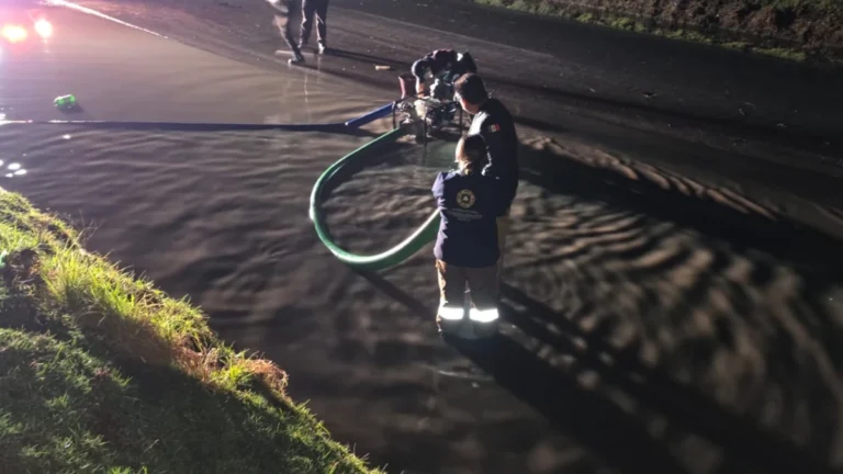
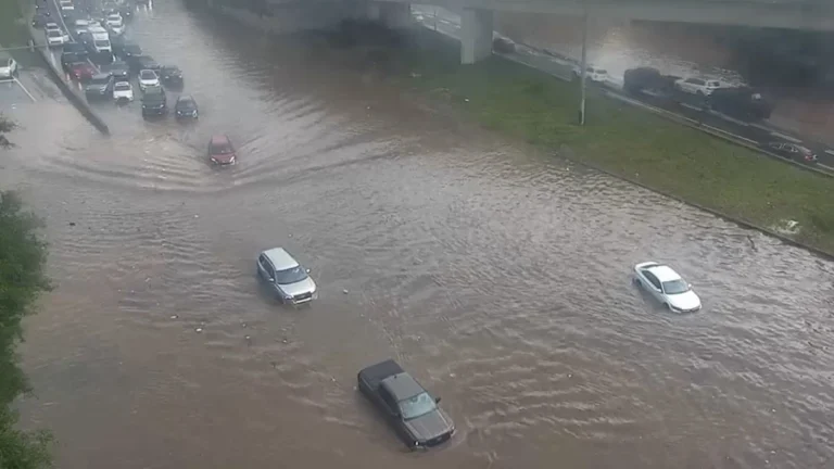
• Rare severe weather outbreak brings tornado risk to Gulf states

    A rare severe convective setup is forecast to develop across the Gulf region, including the United Arab Emirates, Qatar, and eastern Saudi Arabia, on March 26–27, 2026, as a deep low-pressure system and strong upper-level trough interact with high instability and wind shear. The environment may support organized thunderstorms capable of producing tornadoes, alongside heavy rainfall, hail, and damaging winds.

  • March flooding leaves 37 dead and nearly 138 000 affected across Mozambique

    Severe flooding across Mozambique between March 1 and 21, 2026, left at least 37 people dead and affected 137 983 people as heavy rainfall and elevated river levels impacted several provinces. The flooding caused displacement, infrastructure damage, and access constraints, while continued rainfall maintained flood risk in multiple river basins.

  • Record seasonal snowfall measured at Juneau International Airport, Alaska

    Juneau International Airport in Alaska recorded 511 cm (201.2 inches) of snowfall for the 2025/26 season through March 23, setting a new seasonal record for the airport. The total exceeds the previous airport record of 502.7 cm (197.9 inches) from 2006/07, while daily snowfall records were also set on March 22 and 23, and the March monthly total reached a record 175.8 cm (69.2 inches).

  • Strong earthquake swarm on the Reykjanes Ridge, Iceland

    An earthquake swarm with over 300 events over 48 hours is in progress on the Reykjanes Ridge southwest of Eldey, Iceland, since March 23, 2026, with the largest earthquake thus far registered as M4.4. The Icelandic Meteorological Office said there are no indications linking the activity to volcanic processes on the Reykjanes Peninsula.

  • Major multi-day rainfall event forecast across Middle East from March 25-31

    A large-scale storm system is forecast to bring heavy to extremely heavy rainfall across parts of the Middle East, including Iraq, Iran, and the Gulf states, between March 25 and 31, 2026, raising flood risk in urban and desert regions. Authorities in the United Arab Emirates have issued warnings for unstable conditions with rain, strong winds, and reduced visibility, while flooding has already caused fatalities in Oman. Parts of the region might see a year’s worth of rain or more through the course of the event.

  • Eruption at White Island raises Alert Level to 3 after brief ash plume, New Zealand

    A new volcanic eruption occurred at Whakaari/White Island, New Zealand, at 17:35 LT on March 24, 2026, producing a dark grey ash plume rising to about 1 300 m (4 265 feet) above the vent. Authorities raised the Volcanic Alert Level to 3 and the Aviation Color Code to Orange following the event. Activity has since ceased, but further explosive events remain possible with little or no warning.

  • Major M7.5 earthquake hits Tonga region

    A major earthquake registered by the USGS as M7.5 struck Tonga at 04:37 UTC on March 24, 2026. The agency is reporting a depth of 237.5 km (147.6 miles). EMSC is reporting M7.6 at a depth of 218 km (135.5 miles). According to available data, there is no tsunami threat from this event.

  • Record heat spreads east as over 200 record highs are forecast across the U.S.

    Record heat is forecast to persist across parts of the western and central United States through March 25, 2026, with the National Weather Service warning that more than 200 daily record highs could be set as above-normal temperatures spread from the West back into the central and southern Plains. A brief cooldown over parts of the central and eastern U.S. on March 23 is expected to be short-lived. The Storm Prediction Center has issued a severe thunderstorm outlook for Thursday, March 26, covering areas from northeast Missouri to western and northern Ohio.

  • Widespread snow, freezing rain, and strong winds forecast as cross-country storm impacts Canada

    A cross-country storm is forecast to affect multiple regions of Canada from March 23 through midweek, bringing snow to western and central areas before spreading mixed precipitation and stronger impacts into parts of Ontario, Quebec, and Atlantic Canada. The highest-confidence snowfall totals, reaching 20 to 40 cm (8 to 16 inches) in parts of Newfoundland and elsewhere in Atlantic Canada, are expected to create hazardous travel conditions, reduced visibility, and local transport disruptions.

  • Heavy rainfall and flooding impact Northern Territory as ex-Tropical Cyclone Narelle moves west

    Heavy rainfall from ex-Tropical Cyclone Narelle triggered flooding across parts of the Northern Territory, Australia, between March 21 and 23, 2026, inundating properties, disrupting infrastructure, and prompting evacuations. As of March 23, the system was moving west across the Kimberley and had a high chance of redeveloping into a tropical cyclone over waters off Western Australia by March 25, with further strengthening forecast. Severe weather was expected to continue across northern Kimberley through March 24.