
How did one flash of lightning, lasting about seven seconds, stretch 829 km across five US states, beat the previous record by 61 km, and only be recognized as the longest ever measured nearly eight years later?
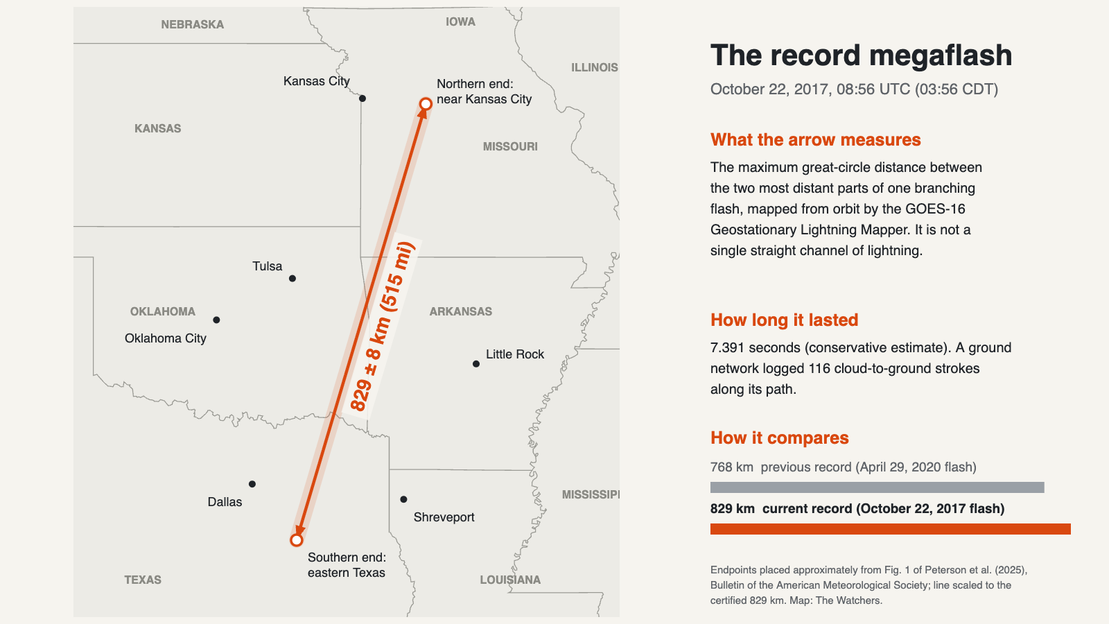
At 08:56 UTC on October 22, 2017, a single lightning flash spread through the clouds of a storm system over the southern Great Plains, reaching from eastern Texas to near Kansas City, Missouri, in a little over seven seconds. A weather satellite recorded it. Nearly eight years passed before the WMO certified it as the longest lightning flash ever measured.
On July 31, 2025, the World Meteorological Organization (WMO) certified the flash as the new world record for distance, at 829 ± 8 km (515 ± 5 mi). That is 61 km longer than the previous record of 768 km, set by a flash over the southern United States on April 29, 2020. The analysis behind the certification was published in the Bulletin of the American Meteorological Society.
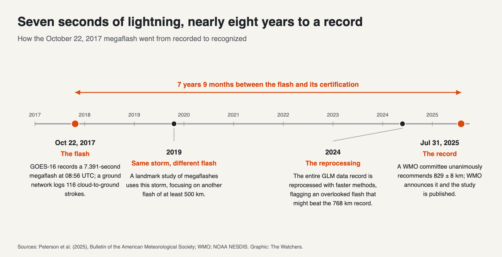
The flash was not hiding in some obscure dataset. According to NOAA, it was captured by the GOES-16 satellite but was not identified in the original 2017 analysis of the storm, and only emerged when scientists went back through the data. How a discharge that enormous goes unrecognized for years is the real story behind the record.
What 829 km actually measures
The record does not describe a single straight bolt stretching from Texas to Missouri. It belongs to a megaflash, which the study defines as a single continuous flash more than 100 km long, typically lasting 5 seconds or more. Megaflashes spread horizontally through the clouds as a branching network of discharges, sometimes setting off up to hundreds of cloud-to-ground strokes along their paths.
The flash was mapped from space by the Geostationary Lightning Mapper (GLM) on GOES-16, an optical instrument that watches for the brief flicker of lightning lighting up the cloud tops below. The WMO measures a flash’s length as the maximum great-circle distance across it. In practice, that means the straight-line distance over the curved Earth between the two most distant parts of the flash detected by GLM, measured between the energy-weighted centers of those detections. The arrow on the map above shows that span, not the path of any individual channel.
On the ground, the Earth Networks Total Lightning Network detected 116 cloud-to-ground strokes along the flash’s path, 83 of them negative and 33 positive, according to the study.
The researchers also compared the flash with weather radar. It spread from the storm’s leading line of thunderstorms to fill nearly the entire region of moderate rainfall behind it, an area outlined by 25 dBZ radar reflectivity. Because that rain region tracks the ice and water particles that may carry electric charge, the team concluded the flash came close to the maximum extent this storm could have produced.
A storm scientists had already studied
The flash came from a long line of thunderstorms that crossed the central United States on October 21 and 22, 2017, ahead of a sharp cold front stretching from Minnesota into northern Texas. After 00:00 UTC on October 22, as the line approached Oklahoma City, it developed a large region of lighter, steadier rain behind the main storms, a structure meteorologists call a trailing stratiform region. That region reached its greatest size and intensity between 04:00 and 09:00 UTC, then slowly decayed over Missouri and Arkansas around dawn.
This was not an overlooked storm. The same system was the focus of a landmark 2019 study led by Walter A. Lyons, the seminal paper that introduced the concept of megaflashes using GLM data. That paper concentrated on one of the storm’s many megaflashes, a discharge at least 500 km long.
The record-breaking flash began later in the storm’s life. The new study describes it as coming from a storm “previously analyzed for its large flashes but in a later, more mature state.” The record was sitting in a dataset scientists had already examined, a few hours after the part they had focused on.
How it surfaced
The turning point came in 2024, when the entire GLM data record was reprocessed with new computational methods. According to the study, their improved efficiency allowed difficult portions of the data record to be examined. That reprocessing flagged a “hitherto-overlooked discharge” in the early hours of October 22, 2017, that was potentially longer than the 768 km record.
A preliminary analysis put the flash at 829 km, and the WMO formed an evaluation committee to judge the candidate. The study was led by Michael J. Peterson of the Georgia Tech Research Institute’s Severe Storms Research Center, with WMO rapporteur Randall S. Cerveny of Arizona State University as corresponding author. Its acknowledgments credit Patrick Gatlin for contributing to the initial evaluation.
The paper does not set out step by step why the 2017 analysis missed this particular flash beyond the improvements in processing. It does place the record within a broader pattern, stating that “flashes at this extreme scale have always existed and are now becoming identifiable” as detection and processing improve. This has happened before. By 2020, Peterson, then at Los Alamos National Laboratory, had developed software to repair flashes that GLM’s standard processing had artificially split, and an improved version helped reveal the earlier 709 km distance and 16.73-second duration records.
Proving it was one flash
Finding a long trail of light in satellite data is not the same as proving it was a single flash. The committee examined two weaknesses of GLM in particular.
The first is cloud blocking. GLM sees lightning through the cloud tops, so light from flashes low in thick cloud can be scattered and dimmed before it reaches the satellite, leaving gaps in time or holes in space. The second is overclustering. GLM assigns light to the same flash when detections fall within 330 milliseconds and 16.5 km of each other, so separate flashes occurring close together can be merged into one, which would exaggerate a flash’s length.
The committee noted that the choice of clustering method matters most in intense storms with very high flash rates, and much less in the low-flash-rate stratiform clouds where this flash spread. It also tested a different method, which groups detections by the center points of larger clusters, as used with the Lightning Imager on EUMETSAT’s Meteosat Third Generation satellites. That method broke parts of this flash apart, but the committee found the breaks were an artifact: when a fast-moving branch lit up a long strip of cloud within a single imaging frame, it was reduced to one center point that jumped beyond the distance limit, even though the light itself was continuous.
Committee members also questioned whether electric fields in the storm could have been strong enough to drive a discharge that far. They pointed to the storm’s structure. Megaflashes like this tend to start near the top of the leading line of storms and travel rearward and downward into the charge-rich stratiform region behind it. As a check, the committee examined a storm from October 31, 2024, with a similarly long leading line of about 1 100 km. Its megaflashes reached only about 300 km, and its stratiform region was weaker and less organized, which suggests the structure behind the leading line is what makes the extreme lengths possible.
The committee also took a conservative approach to timing. Excluding any components that might not belong to the flash, it put the duration at 7.391 seconds. That is far short of the separate world record for duration, 17.102 seconds, set over Uruguay and northern Argentina in June 2020. The study notes that larger flashes can be shorter, depending on how fast their leaders travel and how their channels branch.
After reviewing the imagery and data files, the committee unanimously recommended that the 829 ± 8 km extent be recognized as the new world record. In its words, “This case is prototypical on many accounts.”
Recorded is not the same as recognized
The most striking part of this record is that nothing new had to be observed. GOES-16 captured the flash in 2017. What changed was the ability to process years of satellite data efficiently enough to find it, and the scrutiny needed to confirm that it was real.
That gap is likely to produce more surprises. Lightning mappers have now flown on the GOES-16 through GOES-19 satellites, and similar instruments operate on Europe’s Meteosat Third Generation and China’s FY-4 satellites, so the record of observations keeps growing. “It is likely that even greater extremes still exist,” Cerveny said in the WMO announcement.
Why it matters on the ground
Megaflashes are not just a record-book curiosity. Because they spread through the stratiform region behind the main storms, they can send strokes to the ground far from where lightning seems to be active. The study notes that such flashes often occur in areas well away from the centers of lightning activity, and sometimes much later than 30 minutes after the last local thunder was heard. Committee member Walt Lyons calls this a “bolt from the gray.”
The WMO’s safety advice reflects that. The only places reliably safe from lightning are substantial buildings with wiring and plumbing, or fully enclosed metal-topped vehicles. Beaches, bus stops, dune buggies and motorcycles are not.
References:
1. Peterson, M. J., et al. (2025). A New WMO-Certified Single Megaflash Lightning Record Distance: 829 km (515 mi) Occurring on 22 October 2017. Bulletin of the American Meteorological Society, 106(9), 627–631.
2. WMO. (2025, July 31). WMO certifies megaflash lightning record in USA.
3. NOAA NESDIS. (2025, August 4). NOAA satellites help certify world’s longest lightning flash.
4. Lyons, W. A., et al. (2019). Megaflashes: Just how long can a lightning discharge get? Bulletin of the American Meteorological Society, 101, E73–E86.
5. Peterson, M. J., et al. (2020). New World Meteorological Organization certified megaflash lightning extremes for flash distance (709 km) and duration (16.73 s) recorded from space. Geophysical Research Letters, 47, e2020GL088888.

The Watchers Staff covers earthquakes, volcanoes, severe weather, space weather and other natural events. Published since 2011, The Watchers reports on a changing planet and the science behind it.
