
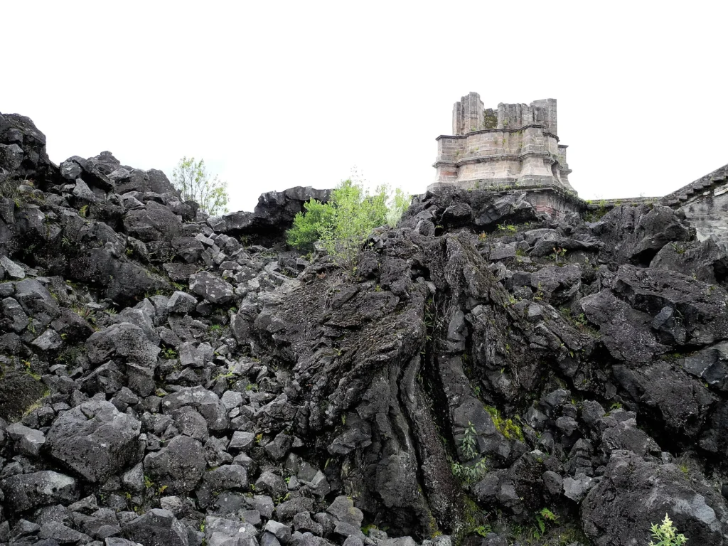
In February 1943, a farmer named Dionisio Pulido watched a crack in his cornfield in Michoacán, Mexico, begin to hiss and smoke. Within a year it had grown into a volcano 336 meters tall, and the bell tower of a church in a town its lava buried still rises out of the rock.
Parícutin erupted from a fissure in farmland near the village of Parícutin in Michoacán, Mexico, on February 20, 1943. Its scoria cone reached 336 m (1 100 feet) during its first year, while lava and ash forced residents of Parícutin and San Juan Parangaricutiro to abandon their settlements during the eruption, which continued until 1952.
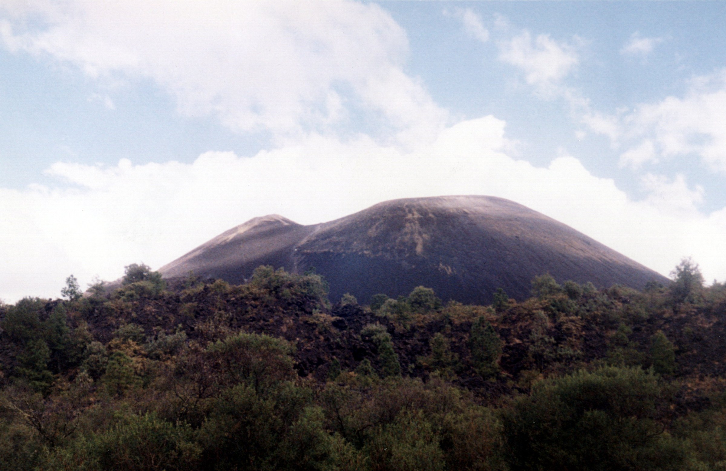
Parícutin volcano in Michoacán, Mexico. Credit: Karla Yannín Alcázar Quintero, CC BY 2.0, via Wikimedia Commons.
The eruption gave scientists an opportunity to observe the development of a volcano from its first activity through the end of a single eruptive episode. Field observations, photographs and eyewitness accounts documented the growth of the cone, the opening of new vents and the advance of lava across surrounding farmland. Much of this evidence was assembled by William F. Foshag and Jenaro González Reyna in their 1956 U.S. Geological Survey (USGS) investigation, Birth and development of Parícutin volcano, Mexico.
A fissure in a cornfield
Approximately two weeks of local earthquakes and subterranean noises preceded the eruption. Testimony collected by Foshag and González Reyna describes tremors increasing in frequency and intensity during February 1943. Felipe Cuara Amezcua, a municipal official, recalled experiencing more than 200 tremors in one day, a figure based on eyewitness recollection rather than instrumental measurements.
At approximately 16:30 LT on February 20, witnesses observed an explosion at a newly formed fissure in the Cuiyútsuru fields, about 2 km (1.2 miles) southeast of Parícutin village. Dust and hot stones rose from the opening as its walls collapsed and the vent widened. Within approximately eight hours, the volcano was ejecting incandescent volcanic bombs in increasingly powerful explosions.
Dionisio Pulido owned the farmland where the eruption began. The USGS investigators also interviewed his wife, Paula Cervantes Rangel de Pulido, his brother Dolores Pulido and other residents. Farmworker Demetrio Toral had been plowing near the opening shortly before the outbreak. Their accounts, together with records maintained by officials in San Juan Parangaricutiro, formed the basis of the investigators’ reconstruction of the eruption’s first hours.
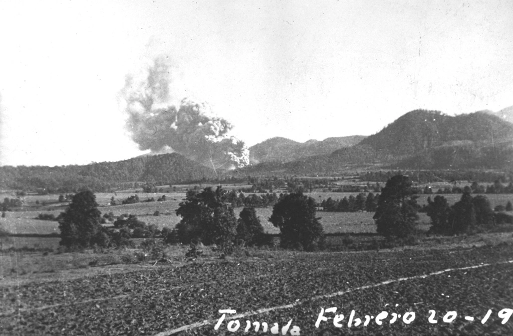
Explosions deposited scoria, volcanic bombs and ash around the vent, rapidly constructing a steep-sided cone. Early measurements published in separate USGS studies were not consistent: Foshag and González Reyna cited Ramiro Robles’s measurement of 167 m (548 feet) on February 26, 1943, while Kenneth Segerstrom reproduced a height of 106 m (348 feet) for February 27, based on figures from Flores and Foshag. Lava also emerged during the opening days and spread outward from the growing cone.
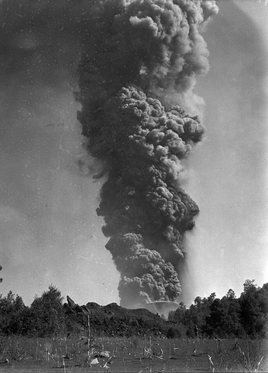
Explosive activity remained strong during March 1943. A photograph taken by Foshag on March 24 shows an ash plume rising approximately 6 km (3.7 miles) above Parícutin, with the advancing Mesa del Corral lava flow visible beyond the cone. Measurements reproduced in Segerstrom’s USGS study place the cone at 336 m (1 100 feet) above its original base on February 20, 1944. Most of its explosive cone-building growth occurred during that first year.
Lava and ash reach two settlements
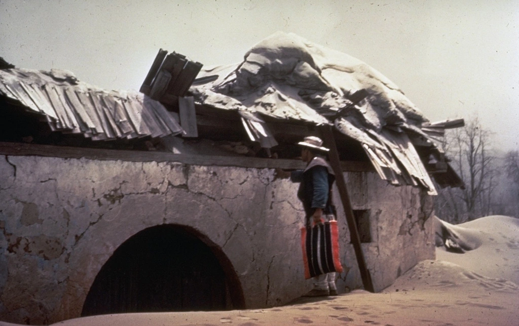
Heavy ashfall damaged farmland, vegetation and buildings around Parícutin village, approximately 3 km (1.9 miles) northwest of the new cone. The Smithsonian Global Volcanism Program documents particularly intense ashfall during the second through fifth months of the eruption. A photograph taken by Frederick Pough in 1943 shows a resident examining the roof of a house destroyed by heavy ashfall.
Residents abandoned Parícutin during 1943 as ash and advancing lava made the village increasingly difficult to occupy. Segerstrom’s USGS investigation records approximately 1 000 residents leaving in April, after more than 1 m (3.3 feet) of ash had accumulated and lava reached the outskirts. A Smithsonian photographic record instead gives 733 residents and places the evacuation about four months after the eruption began. Both sources document resettlement at Caltzontzín, southeast of the former village.
San Juan Parangaricutiro, the larger municipal center, faced a separate threat from advancing lava. USGS historical investigations place its pre-eruption population at approximately 3 000–4 000. By April 24, 1944, the Taquí lava flow had reached the road linking San Juan Parangaricutiro with Uruapan and threatened the town’s waterline. The flow front was then approximately 600 m (1 970 feet) from the outskirts.
Lava entered San Juan Parangaricutiro on June 17, 1944, following the Arroyo Principal along the town’s eastern edge before spreading into adjoining streets. The USGS measured lateral advance of approximately 1–2 m (3.3–6.6 feet) per hour in parts of the flow, while movement down the arroyo was faster. Successive lobes of molten rock covered streets and properties as residents removed belongings and evacuated.
By July 6, 1944, the lava had advanced to within approximately 25 m (82 feet) of the town’s church, according to the USGS field record. Residents dismantled much of the interior as the flow approached. Mexico’s National Institute of Anthropology and History (INAH) documents the removal of structural fittings, the pulpit, benches, bells and religious images, which were transferred to the new settlement of San Juan Nuevo Parangaricutiro.
By the middle of July, lava had covered most of the town, leaving only some outlying areas beyond the flow. The USGS described the church’s towers and apse projecting above the lava, even as surrounding buildings and streets disappeared beneath the advancing rock. Portions of the church’s stone structure remain visible above the solidified lava that covers the former settlement.
Ashfall also destroyed vegetation and disrupted agriculture and livestock grazing beyond the areas directly covered by lava. Segerstrom’s USGS study estimated that approximately 4 500 cattle and 550 horses died, attributing the losses to inhalation of volcanic ash. Mexico’s National Center for Disaster Prevention (CENAPRED) gives the same figures but attributes the deaths principally to food shortages.
Historical accounts also differ over human fatalities. Oregon State University’s Volcano World reports no deaths directly caused by lava or ash, but records three deaths from lightning associated with the eruption. CENAPRED’s February 19, 2025 historical account reports no human deaths, while the Smithsonian eruption database records fatalities in 1943 without specifying a total.
Nine years of eruption
Parícutin continued erupting after its initial period of rapid cone growth. Explosions produced ash, lapilli and volcanic bombs, while lava escaped through vents around the cone. Most explosive cone-building activity occurred during the first year, although explosive eruptions continued during later periods of sustained lava emission.
Foshag and González Reyna divided the first two and a half years into three major eruptive periods: Quitzocho, Sapichu and Taquí. During Quitzocho, the main cone grew and lava spread across fields north of the vent. Activity subsequently shifted to the Sapichu vents at the northeastern base of the cone. The Taquí period included lava emission from vents associated with the southwestern flank and flows that advanced toward San Juan Parangaricutiro.
The Smithsonian Global Volcanism Program records the eruption from February 20, 1943, to February 25, 1952, classifying it as an explosive and effusive event with a Volcanic Explosivity Index (VEI) of 4. In his 1954 USGS petrological investigation, Ray E. Wilcox distinguished the end of lava emission on February 25 from the cessation of explosive activity on March 4, 1952. The cone eventually reached approximately 424 m (1 391 feet) above its original base, while lava covered approximately 24.8 km² (9.6 square miles).
Why a field can become a volcano
Parícutin formed within the Michoacán-Guanajuato volcanic field, part of the Trans-Mexican Volcanic Belt. The Smithsonian Global Volcanism Program identifies more than 1 400 vents distributed across a region approximately 200 km (124 miles) by 250 km (155 miles) in Michoacán and Guanajuato. Scoria cones predominate, although the field also contains small shield volcanoes, lava domes, maars, tuff rings and lava flows.
Parícutin is a monogenetic volcano, meaning that it developed during a single eruptive episode rather than repeated eruptions separated by long periods of inactivity. Such an episode can continue for years and involve several vents. At Parícutin, explosive ejection of fragmented volcanic material built the cone, while lava escaping from vents near its base spread across surrounding terrain and into the nearby settlements.
Jorullo, another monogenetic volcano in the Michoacán-Guanajuato field, erupted from 1759 to 1774. Like Parícutin, it formed a new volcanic cone during a prolonged eruptive episode, although the two volcanoes developed at separate locations within the field.
References:
1 Birth and development of Paricutin volcano, Mexico – U.S. Geological Survey – 1956
2 Erosion studies at Paricutin, State of Michoacan, Mexico – U.S. Geological Survey – 1950
3 Michoacán-Guanajuato – Smithsonian Global Volcanism Program – Database record, accessed November 4, 2026
Featured image: Parícutin volcano in Michoacán, Mexico. Credit: Karla Yannín Alcázar Quintero, CC BY 2.0, via Wikimedia Commons.

I’m a science journalist and researcher at The Watchers, contributing to the Epicenter edition, where I cover peer-reviewed scientific research and emerging discoveries across Earth and space sciences. With a background in astronomy and a passion for environmental science, I’ve worked in shark and coral conservation in Fiji, conducting reef and shark-behavior research, contributing to mangrove restoration, and earning PADI Open Water and Coral Reef Certifications. I bring a blend of scientific rigor and storytelling to illuminate the discoveries shaping our planet and beyond.
