
Hurricane Polo and remnants of Odalys bring heavy rain and flash flood risk across the Four Corners region, U.S.
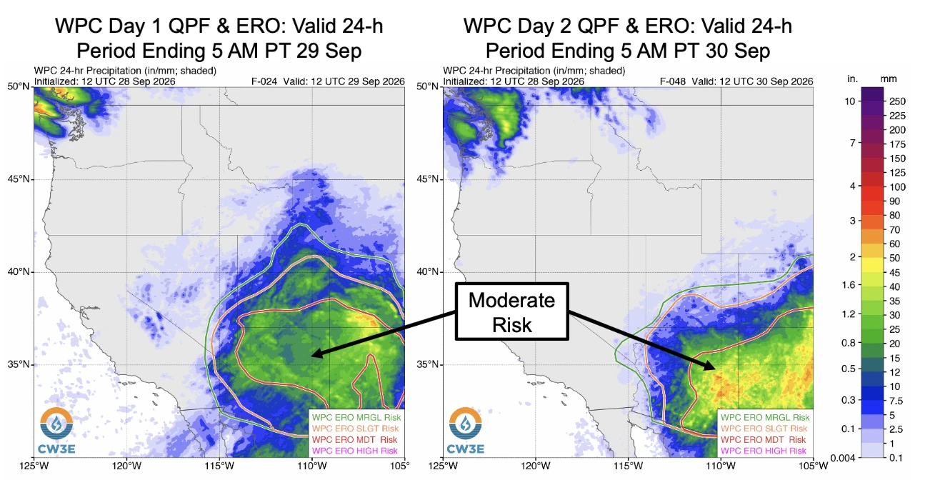
Heavy rain is forecast across the Four Corners region through 05:00 PT (12:00 UTC) on September 30, 2036, with 50–100 mm (2–4 inches) expected across much of eastern Arizona, western New Mexico, and the San Juan Mountains of southwestern Colorado. Moderate Risk excessive-rainfall outlooks, level 3 of 4, cover much of Arizona and New Mexico and parts of southern Utah and southern Colorado, corresponding to a ≥40% probability of flash flooding.
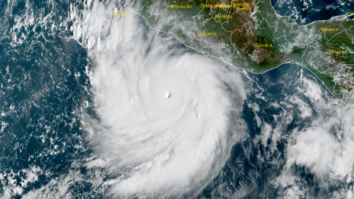
Satellite image of Category 5 hurricane polo at 15:10 UTC on September 22, 2026. Credit: NOAA/GOES-18, RAMMB/CIRA, The Watchers
Tropical moisture associated with Hurricane Polo and the remnants of Odalys is forecast to spread into the interior southwestern United States.
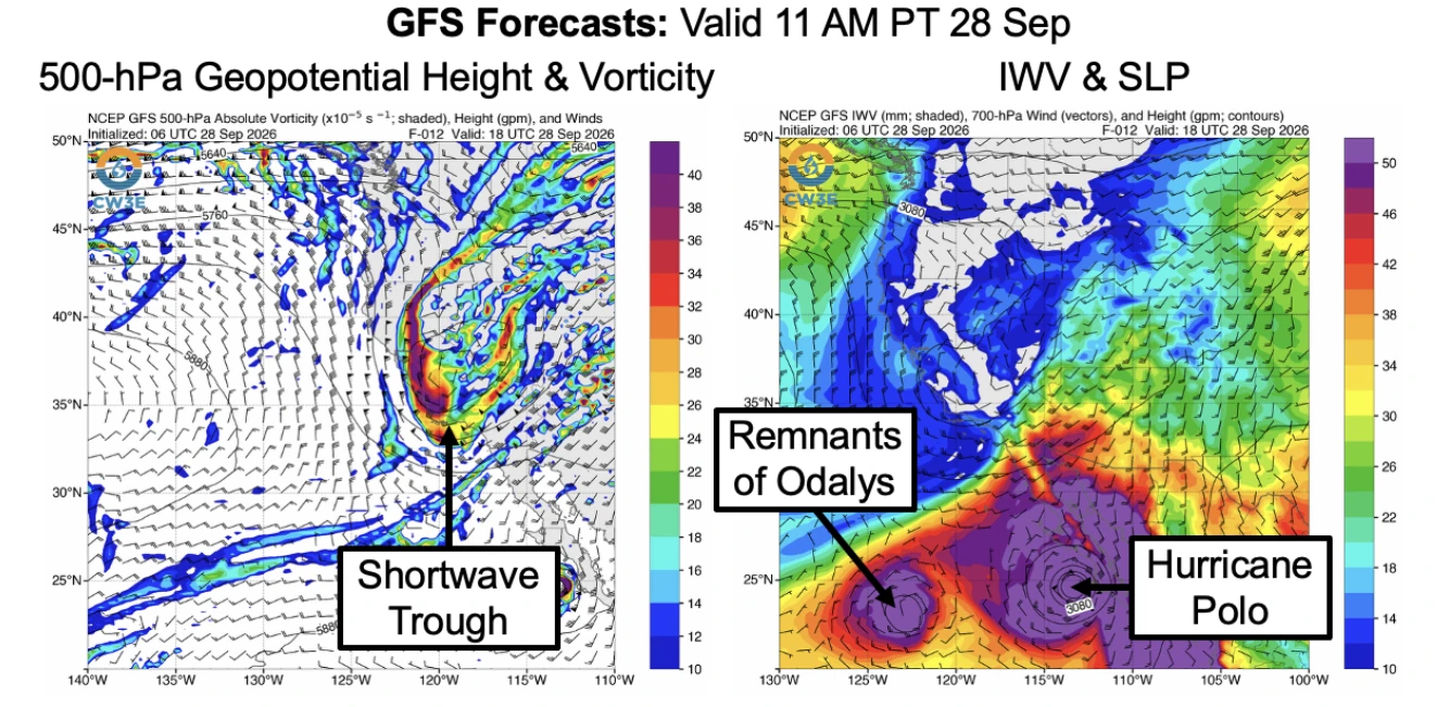
A mid-level shortwave trough over California was forecast to slowly propagate eastward during the following few days, with tropical moisture and dynamical forcing for ascent downstream of the trough supporting moderate-to-heavy rainfall across the Four Corners region, especially Arizona and New Mexico.
The National Weather Service Weather Prediction Center forecast at least 50–100 mm (2–4 inches) of total precipitation across much of eastern Arizona, western New Mexico, and the San Juan Mountains of southwestern Colorado through 05:00 PT (12:00 UTC) on September 30.
Moderate Risk excessive-rainfall outlooks, level 3 of 4 and corresponding in the Quick Look to a ≥40% probability of flash flooding, were issued for much of Arizona and New Mexico and parts of southern Utah and southern Colorado.
The Little Colorado River is forecast to exceed flood stage at Winslow and Holbrook, Arizona, later in the week, while six other stream gauges are forecast to exceed action stage.
At Holbrook, the river was at 1.99 m (6.53 feet) at 12:30 MDT (18:30 UTC) on September 28. Flood stage is 4.72 m (15.5 feet), while the forecast hydrograph showed a rise to approximately 5.43 m (17.82 feet) around September 30. The higher value was forecast rather than observed at the time represented in the Quick Look.
Integrated water vapor was forecast to exceed 40 mm over southern Arizona and approach 30 mm across portions of the Upper Colorado River Basin. CW3E linked the moisture from Polo and the remnants of Odalys with the eastward-moving shortwave trough as the setup supporting the regional rainfall.
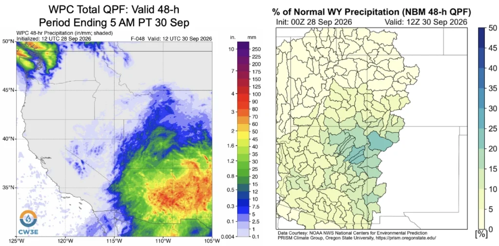
Deterministic and ensemble model guidance showed the potential for some watersheds in northeastern Arizona and northwestern New Mexico to receive more than 20% of normal total water-year precipitation from the event.
Forecast precipitation amounts remained uncertain. The ECMWF ensemble generally favored higher totals across much of Arizona and southwestern Colorado than the Global Ensemble Forecast System (GEFS). In the Middle Little Colorado watershed, more than 50% of ECMWF ensemble members forecast more than 20% of annual precipitation, while approximately 50% of GEFS members forecast more than 10%.
For the Middle Little Colorado watershed, the comparison showed a GEFS ensemble mean of approximately 37.3 mm (1.47 inches) and an ECMWF ensemble mean of 63.5 mm (2.50 inches), a difference of approximately 26.2 mm (1.03 inches).
As of 08:00 PT (15:00 UTC) on September 28, Hurricane Polo was less than about 160 km (100 miles) west of the Baja Peninsula, with maximum sustained winds of approximately 185 km/h (115 mph).
Polo was forecast to move northeastward during the following 36 hours, bringing storm surge, dangerous winds, extreme rainfall, and flash flooding to portions of Baja California Sur and western mainland Mexico. Moisture associated with Polo and the remnants of Odalys was forecast to spread into the interior southwestern United States.
CW3E said rainfall from the event would likely provide some drought relief to parts of the southwestern United States, especially areas experiencing severe-to-exceptional drought in New Mexico and southern Colorado. CW3E advised readers to monitor official NWS forecasts, watches, and warnings and follow guidance from local emergency management officials.
References:
1 Quick Look at Potential for Heavy Rain and Flooding in the Four Corners Region – CW3E – September 28, 2026

Rishav Kothari is Editor-in-Chief of The Watchers, where he runs the newsroom and covers earthquakes, volcanoes, severe weather and space weather.
Published in the last 24 hours
- NASA built the Opportunity rover to last 90 days on Mars, and Martian winds helped keep it alive for nearly 15 years by blowing dust off its solar panels, until a planet-wide dust storm in 2018 blocked sunlight and silenced the rover Epicenter
- In the winter of 1811–12, earthquakes near New Madrid, Missouri, shook so hard that witnesses saw the Mississippi River flow backward, and the shaking left a brand-new lake in Tennessee Epicenter
- On 28 August 1859 a solar storm shocked telegraph operators and threw sparks on other lines, and on 2 September Boston to Portland clerks unhooked their batteries and kept sending for more than two hours on the aurora's current alone. Epicenter
- In 2019, the Ronald Reagan Presidential Library hired hundreds of goats to eat 13 acres of brush around it; months later the Easy Fire surrounded the library, and the fire break the goats left behind slowed the flames before they reached the building Epicenter
