
Hurricane Polo forecast to make two landfalls in Baja California Sur and Sonora, Mexico
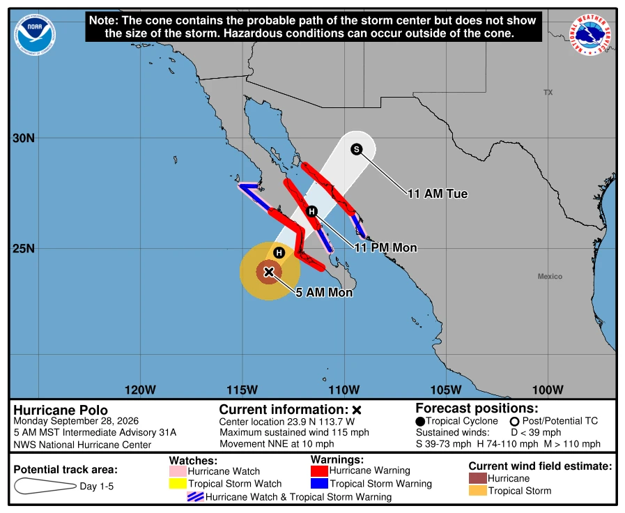
Category 3 Hurricane Polo was approaching Baja California Sur on September 28, 2026, as Hurricane Warnings covered sections of both coasts of the peninsula and mainland Sonora. At 05:00 MST (12:00 UTC), the National Hurricane Center placed Polo 175 km (110 miles) southwest of Cabo San Lázaro with maximum sustained winds of 185 km/h (115 mph), and forecast landfall in Baja California Sur late that afternoon or early evening before the cyclone reached southern Sonora as a hurricane late that night or early September 29.
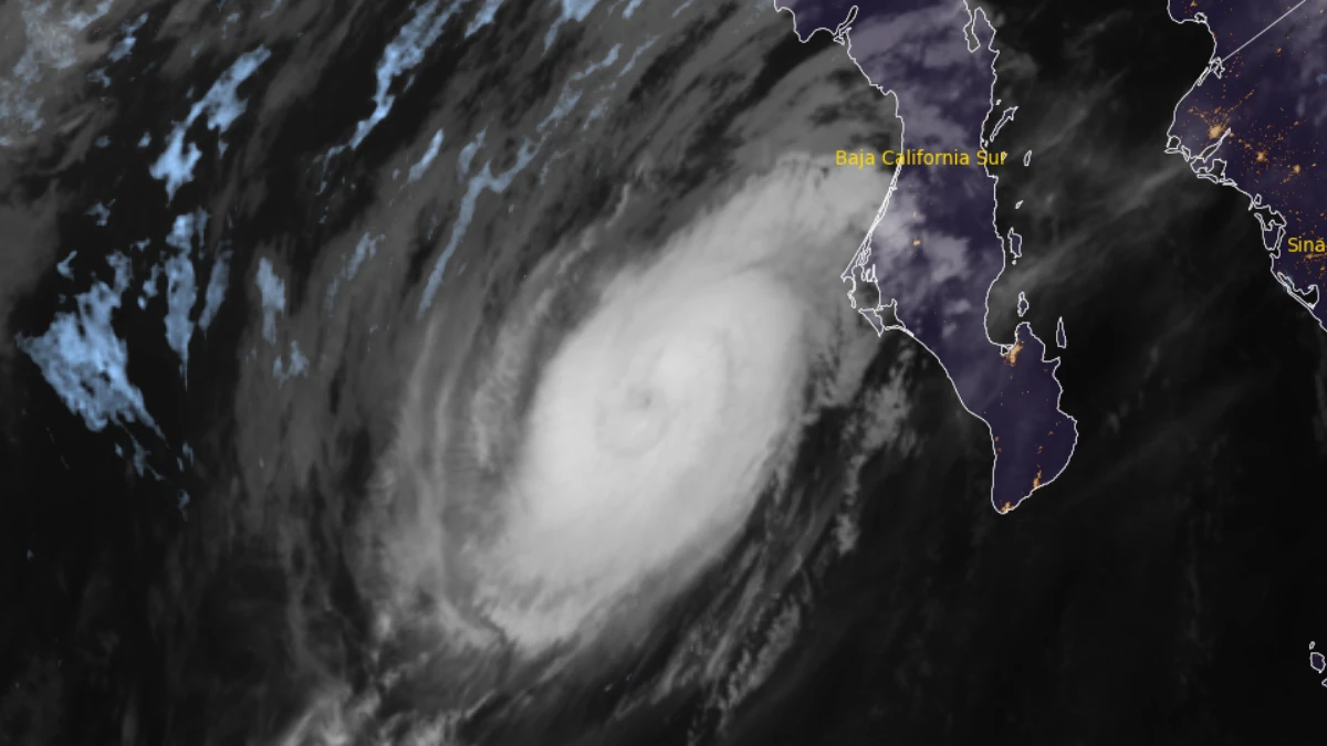
Satellite image of Hurricane Polo at 11:50 UTC on September 28, 2026. Credit: NOAA/GOES-19, RAMMB/CIRA, The Watchers
At 12:00 UTC, Polo was centered approximately 175 km (110 miles) southwest of Cabo San Lázaro and 405 km (250 miles) south-southwest of Santa Rosalía.
The hurricane was moving north-northeast at 17 km/h (10 mph), with one-minute sustained winds of 185 km/h (115 mph), and an estimated minimum central pressure of 958 hPa.
Hurricane-force winds extended up to 65 km (40 miles) from the center, while tropical-storm-force winds extended up to 165 km (105 miles).
Hurricane Warnings covered the west coast of Baja California Sur from Punta Abreojos to Santa Fe, the east coast from Loreto to Bahía San Juan Bautista, and mainland Mexico from Bahía Kino to Huatabampito.
Hurricane Watches and Tropical Storm Warnings were in effect on the west coast north of Punta Abreojos to Punta Eugenia, on the east coast south of Loreto to San Evaristo, and on the mainland south of Huatabampito to Topolobampo.
Tropical-storm conditions were expected to begin in the southern part of the warning area during the morning of September 28, followed by hurricane conditions along the warned west coast by late afternoon. The conditions were forecast to spread northward and eastward across the peninsula through the night and reach the mainland warning area late September 28 or early September 29.
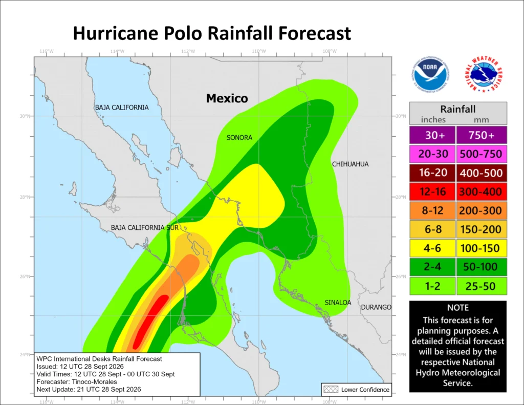
Rainfall totals of 150–305 mm (6–12 inches) were forecast across parts of Baja California Sur. Southern and central Sonora were forecast to receive 100–150 mm (4–6 inches), with maximum totals near 200 mm (8 inches). The rainfall could produce life-threatening flooding and mudslides, particularly in steep terrain.
Polo is expected to turn northeast as a mid-level ridge over northern Mexico, and an amplifying trough over California steered the cyclone toward the peninsula. The center was forecast to move inland along Baja California Sur late on September 28, briefly cross the Gulf of California, and make a second landfall in southern Sonora late that night or early September 29.
Increasing vertical wind shear was expected to cause some weakening, but the most likely scenario kept Polo near major-hurricane strength at the Baja California Sur landfall and at hurricane strength when it reached mainland Mexico.
Rapid weakening was forecast after the second landfall as the circulation moved across the rugged terrain of northern Mexico.
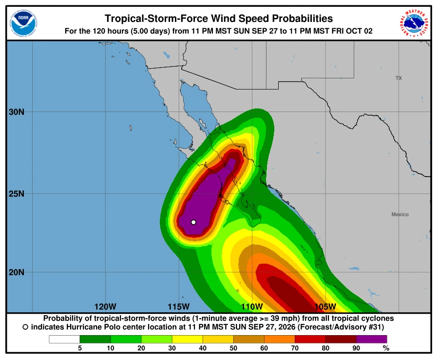
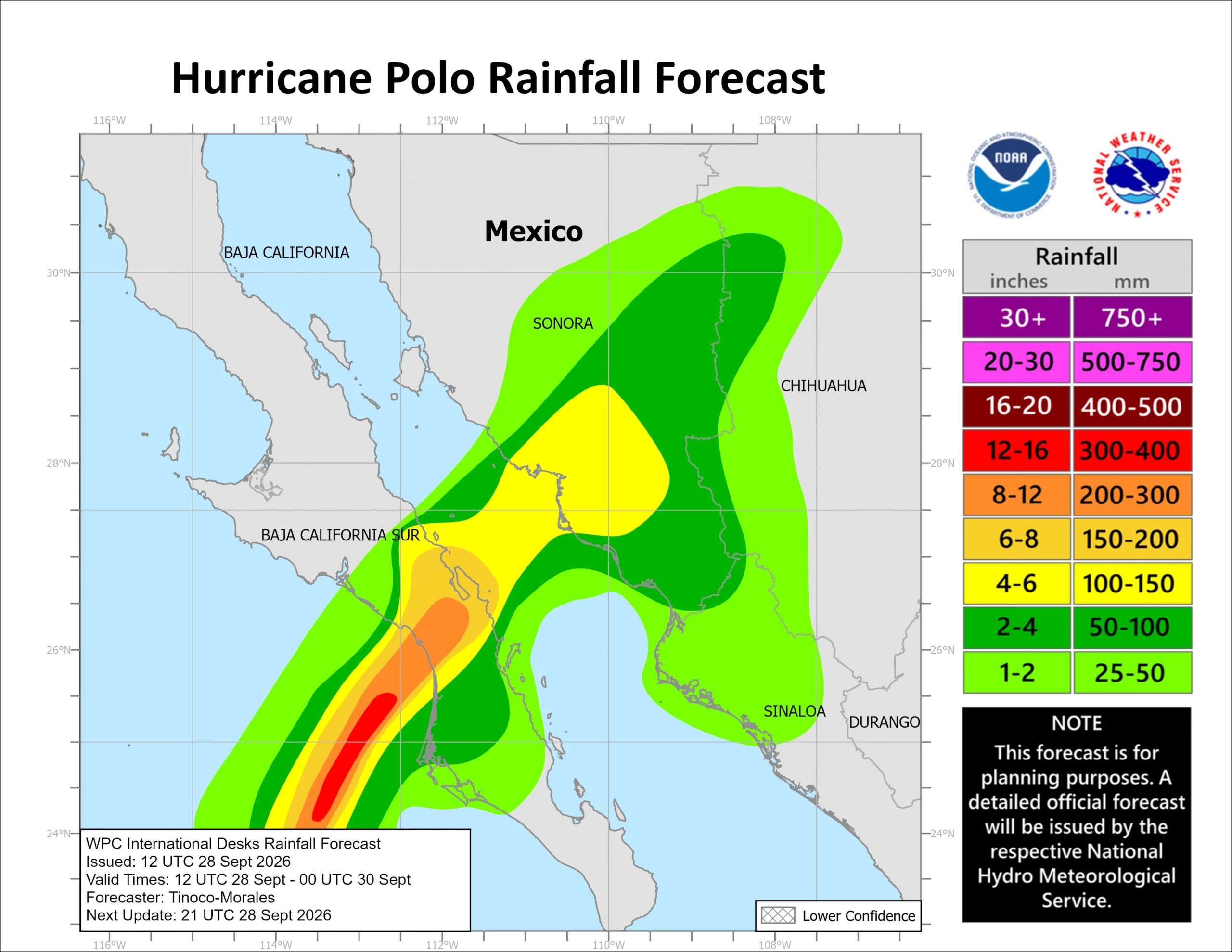
NHC said storm surge could produce significant coastal flooding in areas of onshore winds, accompanied by large and destructive waves. Swells affecting west-central Mexico and the Baja California Peninsula were expected to generate life-threatening surf, rip currents, and coastal flooding during the following two days.
Baja California Sur suspended school activities through September 29 in all five municipalities and halted routine state, municipal and federal government work in the state on September 28 and 29. Maritime activities were also suspended, and the State Civil Protection Council established a command post in Comondú to coordinate preparedness and response.
The state listed 169 potential temporary shelters with total capacity for 33 192 people. The inventory comprised 111 Plan A shelters and 58 Plan B facilities to be activated if conditions required.
State officials identified Comondú, Loreto and Mulegé as the principal areas of concern and said ports remained closed to navigation. They urged residents to follow Civil Protection instructions and use temporary shelters when directed.
References:
1 Hurricane Polo Intermediate Advisory Number 31A – NOAA/NHC – September 28, 2026
2 Hurricane Polo Forecast Discussion Number 31 – NOAA/NHC – September 28, 2026

Rishav Kothari is Editor-in-Chief of The Watchers, where he runs the newsroom and covers earthquakes, volcanoes, severe weather and space weather.
Published in the last 24 hours
- A tangled sunspot cluster about 93 million miles away doubled in size in a single weekend earlier this month and fired 20 solar flares in one day, and forecasters gave it a small chance of producing an X-class flare, the most powerful kind the Sun is known to unleash
- A ring of wind spinning about 19 miles above the Arctic, far higher than any passenger jet flies, has started breaking apart weeks earlier than ever recorded, and forecasters say the cold it was holding in place could spill into the US and Europe within weeks
- US flights resume after FAA lifts nationwide ground stop that lasted more than four hours
- Second nationwide US flight halt since 9/11: how the November 13 FAA ground stop compares with September 2001 and January 2023 Epicenter
